FROM
END TO END FROM
END TO END
An Overview:
Phoenix to Albuquerque on Foot Segments
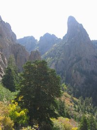
1 & 2 :: Superstition Mountains
Phoenix to Superior
 |
| | The
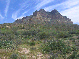
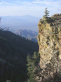
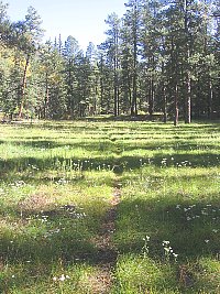
Grand Enchantment Trail begins 45 miles east of downtown Phoenix, AZ at the First
Water Trailhead in the Superstition Mountains (Tonto National Forest).
It follows foot trail east into this rugged volcanic desert range, winding through
lush canyon bottoms and over viewful passes, past saguaro cacti, teddy bear cholla,
jojoba, and other highly-adapted plants of the lower Sonoran desert. Weaver's
Needle, a dramatic rock fang, is often in view, marking the location of the
mythical Lost Dutchman's Gold while adding to the real-world grandeur of
this landscape. East of sheer-walled Upper La Barge Box, the route climbs toward
scenic Horse Ridge and Tortilla Pass, now in the upper Sonoran desert life zone,
before descending to follow the rockbound drainage of Rogers Creek and passing
near a 700 year old Salado cliff dwelling. Here the GET joins the Arizona
Trail, not far from the gravesite and former ranch of Elisha Reavis, the "hermit
of the Superstitions." Following the AZ Trail south, the route climbs chaparral-cloaked
Montana Mountain with sweeping views, then drops steeply to follow the drainages
of Reavis and Whitford canyons, finally leaving the Superstitions and reaching
US Hwy 60 four miles west of the town of Superior nearby the renowned Boyce
Thompson Southwestern Arboretum.
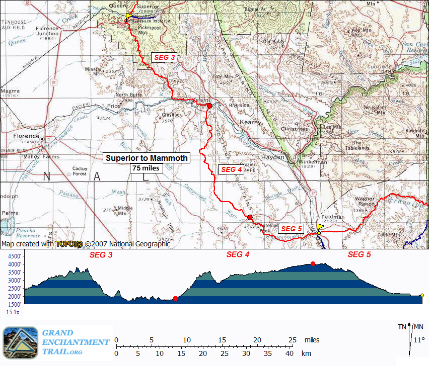
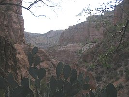
Segments 3 - 5 :: White Canyon Wilderness & Tortilla Mountains
Superior
to Mammoth
 |
| | Continuing
southbound along the route of the Arizona Trail (and sometimes apart from it),
the GET follows a combination of maintained singletrack and primitive foot trail
into the little-known White Canyon Wilderness (BLM), a small but superlative
landscape of remnant volcanic peaks and colorful ash-flow sedimentary cliffs.
The Sonoran desert here is in fine form, with dense stands of saguaro cacti among
a panoply of unique desert flora on display. After a challenging hike along rugged
drainages and old mining roads south of the wilderness area, the route rejoins
the Arizona Trail alongside the tree-lined banks of the Gila River where
it seeks out a bridged crossing upstream. Beyond, the terrain gradually mellows
and long-range views highlight the distant Sky Island range of the Santa Catalina
Mountains near Tucson. Here the route continues to follow an adventurous web
of singletrack trail and connecting dirt roads as it seeks out lone Antelope Peak,
a low volcanic outlier of the Tortilla Mountains. Eventually the GET and AZT part
ways for good, as our route turns east along the wide sandy course of Putnam Wash
in the company of dark basalt cliffs, then along the gentle San Pedro River
in a rare desert riparian oasis, to reach AZ Hwy 77 ten miles north of the small
village of Mammoth AZ.
Segments 6 - 11 :: Aravaipa Canyon, Santa Teresa & Pinaleño
sky islands
Mammoth (and Klondyke) to Safford
 |
| | East
of AZ Hwy 77 the Grand Enchantment Trail heads into Sonoran desert foothills of
the sky-island Galiuro Mountains, wherein lies the entrance to spectacular Aravaipa
Canyon (BLM Wilderness). Sheer canyon walls rise a thousand feet above the
lush, deciduous banks of perennial Aravaipa Creek, where we linger, wet feet and
broad smiles, for some 12 unforgettable miles. Quiet dirt roads resume east of
the canyon, leading within range of the remote outpost of Klondyke - another
potential maildrop resupply location - before our route turns northeast to climb
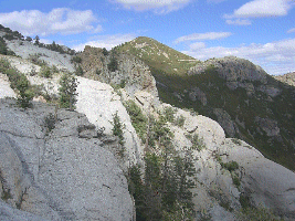
into the extreme rugged terrain of the Santa Teresa Wilderness (Coronado
National Forest). Little-used trails provide supreme solitude as we navigate the
adventurous granite-domed wonderland of Holdout Canyon, then over 7000-foot
Cottonwood Mountain near well-named Pinnacle Ridge, and south to reach Klondyke
Road. A fun yet challenging cross-country connection culminates at Tripp Canyon,
where the GET soon rejoins foot trail to climb high into the forested Pinaleño
Mountains (Coronado NF), passing serene Riggs Lake and the viewful
fire tower atop 10,000-foot Webb Peak, where snow may linger well into spring.
The desert heat seems as far away as the distant horizon atop this tallest of
Arizona's Sky Island ranges, where broad panoramas reveal such distinguished neighbors
as the Rincons, Huachucas, Chiricahuas, as well as the Mogollon Mountains in New
Mexico farther along the GET. Leaving the high country by and by, we follow the
magnificent craggy defile of forested Ash Creek Canyon on down toward the open
desert nearly a vertical mile-and-a-half below, passing through an astonishing
range of life zones in only a few miles of travel. Finally the route joins quiet
greasewood-flanked dirt roads to reach the outskirts of bustling Safford, with
most services available.
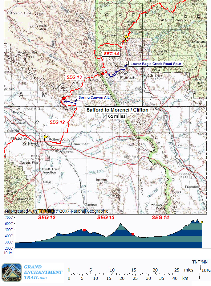
Segments 12 - 14 :: Old Safford-Morenci Trail, Eagle Creek & Painted Bluffs
Safford to Morenci / Clifton
 |
| | The
Old Safford-Morenci Trail follows a former trade route between the two
towns from which it finds its name. The GET follows quiet, viewful dirt roads
and washes north of Safford to join this BLM-administered historic trail in the
high desert Gila Mountains of Arizona, where developed singletrack trail, old
roads, and cairned drainage courses make for interesting, remote, and highly varied
trekking. Colorful box canyons lead into and out of the secluded riparian corridor
of Bonita Creek about half way along, and beyond the route climbs to Bellmeyer
Saddle, a scenic grassy expanse at 6000 feet in elevation. Descending to Eagle
Creek in its rugged, winding gorge - prime bighorn sheep country -
an alternate route soon climbs away, while the main GET turns north, following
Eagle Creek's canyon upstream, with numerous (though generally mild) fords. White-nosed
coati are often seen cavorting among sycamores and cottonwoods in the creekside
riparian forest. At length the Painted Bluff Trail leads us east away from the
river, along the way offering glimpses of ancient pictographs in a high-desert
mountain landscape rich with solitude. Views at last open toward the vast open-pit
of the Morenci copper mine as our route descends to cross the Coronado
Trail, a famously serpentine mountain highway with potential opportunities for
a ride into Morenci village. Historic Clifton, another resupply option,
lies several miles farther downhill, a virtual living history museum to the region's
early mining days.
Segments 15 - 18 :: The Blue Range, Blue River & Maple Peak
Morenci
/ Clifton AZ to Alma & Glenwood NM
 |
| | The
jumbled ridges of Arizona's Blue Range unfold northward and the GET contours
along their slopes, following foot trail flanked by live oak and manzanita, interspersed
with shady conifers and secluded groves of maple alive with color in autumn. Views
eastward extend to the Mogollon Mountains along our route in New Mexico, and to
the nearer canyon system of the Blue River, toward which we now descend.
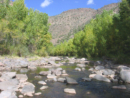
Fording this small river in a remote setting, the wildness of the scene before
us is truly written in the sands at creekside, where Merriam's turkey,
black bear, and mountain lion leave telltale trace of their passage.
Foot trail resumes en route toward prominent Maple Peak (8200'), from which a
vantage of the Blue Range Primitive Area unfolds toward the Mogollon Rim.
Descending to reach the Arizona/New Mexico boundary, the GET joins forest roads
and heads east through classic New Mexican juniper-grassland toward the small
ranching community of Alma, 4 miles north of more tourist-oriented Glenwood.
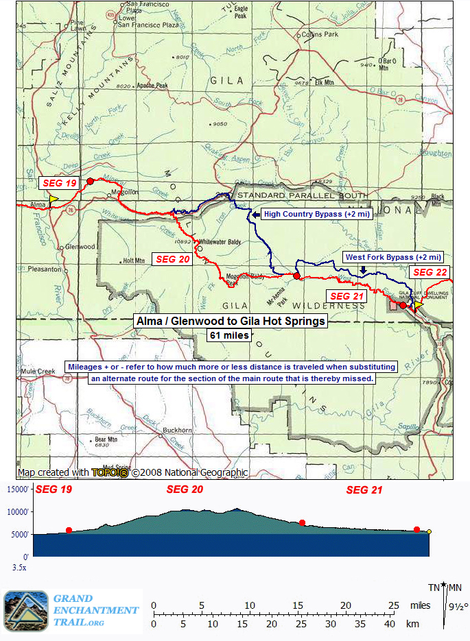
Segments 19 - 21 :: Mogollon Mountains & West Fork Gila River
Alma
& Glenwood to Gila Hot Springs
 |
| | Mineral
Creek east of Hwy 180 offers tantalizing views of the lofty Mogollon Range, which
the GET joins not far from Mogollon ghost town and the renowned Catwalk
National Recreation Trail, a series of suspended walkways along a sheer and
narrow gorge. Entering the Gila Wilderness, our trail gradually gains the 10,000-foot
crest of the range, often snowbound well into spring. (An alternate route circumvents
the crest.) Mogollon Baldy (10,770'), highest mountain directly along the
route, affords truly awe-inspiring vistas from its open summit, including a glimpse
of Mount Graham in Arizona and ahead toward the San Mateo Mountains. Old growth
forest offers opportunities for contemplation along the well-graded descent
toward the West Fork Gila River, where wildflower meadows invite pause
near the entrance to its pinnacled canyon. Foot trail continues into the strikingly
faceted canyon, writhing and fording its way some 16 memorable miles to the entrance
of Gila Cliff Dwellings National Monument. A high-water detour also rejoins
here, 3 miles north of historic Doc Campbell's Trading Post and the community
of Gila Hot Springs.
Segments 22 - 27 :: Gila Country and the Continental Divide
Gila Hot Springs
to Monticello
 |
| | The
Grand Enchantment Trail continues its water-blessed way through the majestic Gila
Country of New Mexico, first along the Middle Fork Gila River, then climbing
above its canyon to cross open mesas toward a meeting with the Gila's gentler
East Fork as well as Diamond Creek, a prime tributary. Foot trails, both maintained
and informal, continue to allow nearly seamless travel as the route enters park-like
Tom Moore Canyon. Here an adventurous side trip gains access to an enticing slot
canyon, while the GET strides more easily in open ponderosa forest - prime
elk habitat - ascending gradually toward amusingly named Me Own Hill. A short
switchbacking descent next accesses the verdant canyon bottom of South Diamond
Creek, where our route begins a final climb toward the Continental Divide. Views
abound on the Black Range Crest near 9800' Diamond Peak, from which the
Continental Divide Trail leads north for several miles of well-graded ridgewalking,
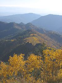
while young aspens lend spectacular fall color in numerous old burns along
the way. To the north the Divide mellows and ponderosas take hold once more as
the GET/CDT tours on purpose-built trail tread. After 45 serene but sometimes
droughty miles, the GET leaves the Continental Divide near Wahoo Peak to head
east, clambering downhill to the Gila National Forest boundary, where we exit
the forest some 140 miles from our entrance near Glenwood. Dirt roads and cross-country
travel then lead through rolling juniper-yucca-grassland desert toward the entrance
to Monticello Box canyon and Ojo Caliente (Warm Spring), the area
still sacred to Apaches whose ancestors once called this land home. Beyond, the
GET climbs above the perennial waters of Alamosa Creek to within a day's walk
of the peaceful hamlet of Monticello, an important resupply opportunity.
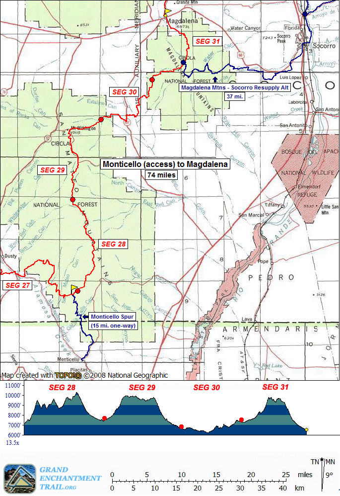
Segments 28 - 31 :: San Mateo and Magdalena Mountains
Monticello to Magdalena
 |
| | The
bold, talus-strewn profile of the San Mateo Mountains looms ahead as the GET follows
a lonely track known as the Burma Road among folded juniper-grassland hills. Ahead,
the rugged defile of Shipman Canyon offers access to the Cibola National Forest
and Apache Kid Wilderness. Infrequently visited and providing one of the
finest high-elevation wilderness experiences along the route, this wilderness
area also provides refuge for mountain lion and black bear, the latter in increasing
numbers. These mountains once legendarily offered human ensconcement as well,
and our route passes near the final resting place of the wanted outlaw called
Apache Kid, high on the 10,000-foot crest of the range. Scenery and solitude
abound as we head north along the rugged ridge, joining the adjacent Withington
Wilderness to explore a pair of fire lookouts, including Mt Withington's (10,100')
with views of the vast Plains of San Agustin below and first glimpses of
the Sandia Crest ahead near Albuquerque. The drainage of Potato Canyon reveals
fascinating volcanic geology as the GET descends east off the crest, back onto
the high desert to follow jeep tracks and cross-country canyons in search of our
next Sky Island range, the Magdalena Mountains. Here, a rugged ascent leads
to one of the finest ridgeline walks on the entire route, with open, alpine-like
terrain near South Baldy (10,783'), frequent meadows, and a knife edge traverse.
The Langmuir lightning research facility is located here as well, alongside the
Magdalena Ridge Observatory, an ultra-high-resolution telescope array currently
under development. Finally the GET returns to high-desert country again near the
famed ghost town of Kelly, 3 miles south of historic Magdalena and our
next wayside along the route.
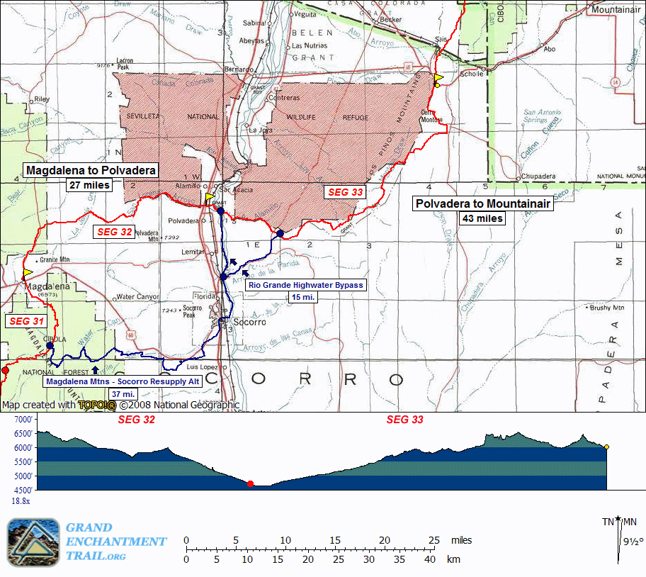
Segments 32 & 33 :: San Lorenzo Canyon, Rio Grande Valley & the Chihuahuan
Desert
Magdalena to Mountainair
 |
| | A
variety of desert environments provide exhilarating open-air walking as the Grand
Enchantment Trail extends northeastward from Magdalena. North of US Hwy 60 the
route makes use of forest roads on a brief tour of the Bear Mountains, then crosses
the wide juniper-grassland valley of La Jencia Creek via an enjoyable network
of primitive 2-tracks and cross-country travel. Ladron Peak, wild and little-explored,
stands sentinel on the distant horizon, while ahead lies the smaller Polvadera
range, which we approach, watching for herds of pronghorn antelope, before
descending to reach San Lorenzo Canyon. Here the route follows a sandy
wash into a colorful, sheer-walled box canyon, with several labyrinthine slots
available for exploration, then reaches the fertile Rio Grande valley and a resupply
option at tiny Polvadera (or larger Socorro). The GET winds through the Rio
Grande bosque, or "riverside woods," fording the wide, often shallow river
(high water detour available), then proceeds back into the Chihuahuan desert,
where cross-country travel and lonely 2-track roads lead past intriguing mesas
and unnamed desert peaks. Our tour of this little-known region culminates again
at Hwy 60, here 18 miles west of Mountainair, a small ranching town offering basic
provisions.
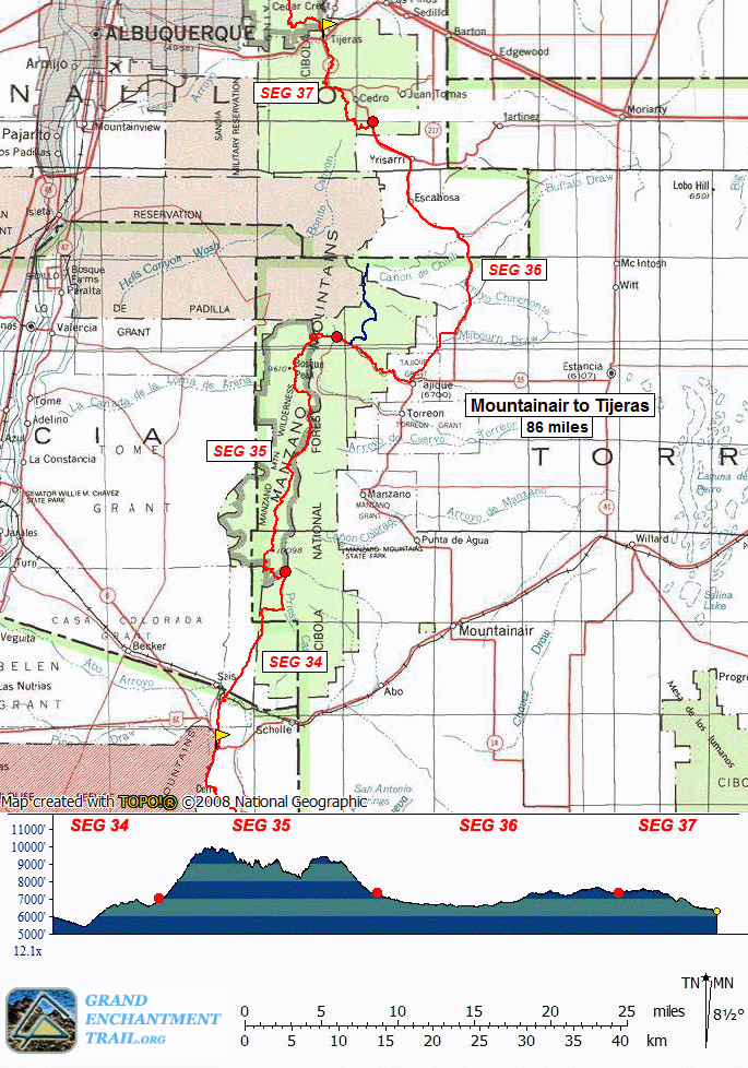
Segments 34 - 37 :: Manzano & Manzanita Mountains
Mountainair to Tijeras
 |
| | The
Abo District of Salinas Pueblo Missions National Monument makes for a worthwhile
detour along US Hwy 60. Northward, the GET explores a series of secluded sandstone
arroyos, often with spring pools, then ascends via 2-track to a pinyon-juniper
forested plateau at the foot of the spectacular Manzano Mountains. A well-worn
forest road leads a half hour or so to Pine Shadow Trailhead, where our route
joins foot trail, climbing sharply to Manzano Peak (10,098') at the southern end
of the fault-block range. Here begins a memorable 2 day traverse of the Manzano
Crest Trail, as we wind along an extraordinary ridge, over summits clad in
spruce and fir, through aspen-blessed meadows, and along the edge of a sheer limestone
"reef," often within sight of the vast Rio Grande valley below. The Manzano
Hawk Watch site is here, an ideal vantage from which to view raptors along
this important migration corridor. Black bear are commonly seen among the forests
and meadows, and especially near Capilla Peak Campground, a popular retreat along
the way. Finally our route descends eastward, leaving the Manzano Wilderness and,
at Canon Tajique, entering a lush forest of Rocky Mountain large-tooth
maples, crimson in fall and among the finest such groves in all of New Mexico.
Regaining the Cibola National Forest at meadow-blessed David Canyon, foot trails
lead us north toward Otero and Cedro canyons, the latter representing a significant
riparian habitat success story here at the wildland-urban boundary. A brief climb
to the juniper-cloaked flanks above Tunnel Canyon rewards with sweeping views
of looming Sandia Crest. A short roadwalk then leads into Tijeras, located along
old Route 66, and offering a final maildrop option for Albuquerque-bound
thru-hikers.
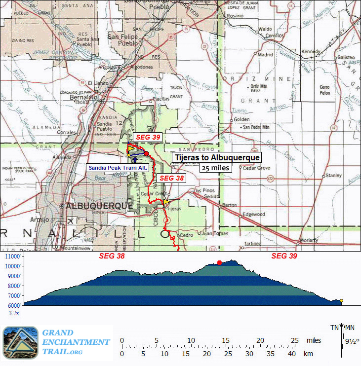
Segments 38 & 39 :: Sandia Mountains & Sandia Crest
Tijeras to
Albuquerque
 |
| | The
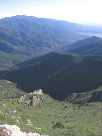
Grand Enchantment Trail ascends the gentle east face of the Sandia Crest - the
final mountain range on our enchanted tour - then suddenly reaches a vantage westward.
The silent mountain drops precipitously to the valley floor and the dazzling spectacle
of Albuquerque overwhelms the senses. Northward along the crest our trail continues,
winding through primeval forest of aspen-spruce-fir and reaching further outlooks
toward the other world beyond. We wander through sunny meadows, encountering few
people, then climb higher, reaching the Sandia Crest Aerial Tram and meeting
perhaps the first tourists of our journey. Now with company we marvel at the spires
and cliffs before us, then climb onward through dense boreal forest toward the
height of the crest (10,678), pausing perhaps for a meal at the summit house.
The GET now descends westward, following the popular La Luz Trail into
rockbound La Cueva Canyon, (then onto the Tramway Trail) a well constructed and
rewarding route that links mountain with desert, wilderness with civilization,
our journey with our memories of a grand and enchanting place.
|