 TIJERAS
NM TIJERAS
NM
Trail
miles from west terminus: 742
Distance
from GET: on route
Twenty-four
miles before reaching its eastern terminus at Albuquerque, the GET passes through
Tijeras (teh HERR es), a bedroom community to the big ABQ, yet one which actually
feels quite distinct from its outsized neighbor, and keeps a small-town "Route
66" profile despite its location along the busy Interstate 40 corridor. Tijeras
itself offers just a few services for hikers, and no groceries, although more
is available 4 miles off-route in Cedar Crest. Also, several small convenience
stores dot the landscape along the main GET route south of town (northbound, the
last one is 14 trail miles south of Tijeras in the residential community of Ponderosa
Pine). Fourteen miles north of Tijeras along the GET lies the Sandia Peak tram
summit station and TEN 3 restaurant; combined with the other eateries along this
corridor, ABQ-bound hikers should be able to forego a maildrop at Tijeras in favor
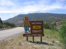
of big meals and take-out food. (Photo:
Smoky the pyrophobic bear greets GET hikers south of town. The Sandia Ranger Distict
of the USFS has its headquarters here in Tijeras, right along the route.)
Back
to GET Town Guide Home |


 TOWN
GUIDE
TOWN
GUIDE