 ORIGINS
| JOURNEY'S THEME | LAYOUT OF THE ROUTE
| APPROACH & PHILOSOPHY
ORIGINS
| JOURNEY'S THEME | LAYOUT OF THE ROUTE
| APPROACH & PHILOSOPHY
PHOTO
JOURNAL |
MAPPING
RESOURCES |
DATA
BOOK
| Update
on the state of the Sky Islands Traverse
PLEASE READ THIS |
|
A safe
and rewarding journey requires the right skills, judgment, attitude, and information.
As of 2023, the detailed information component of this page has taken a hiatus
and you shouldn't use it. This had been a static resource sitting on a web server
for over a decade. In the meantime, the world has changed. Fires and floods have
devastated large swaths of the Sky Island ranges, reclaiming many miles of trail
in the process and rendering the experience exponentially more challenging. In
the lower country surrounding the ranges, a long-standing mix of interdependent
public and private land ownership has increasingly drifted, due to human pressure,
toward acrimony. A static resource that highlighted a one-off experience from
a bygone era has simply proven to be incompatible with a world few could have
predicted, and this includes the current "viral" nature of seemingly
anything posted online, no matter how obscure or unlikely.
This
web page has always stated the following and this rings truer today than ever:
"We're not actively encouraging others to hike the exact route layout as
described, and are less interested in fielding specific questions about planning
and hiking it. On a route as undeveloped as this, your hike should be your decision
and responsibility, and this information should only serve as a catalyst for having
a rewarding and ultimately unique journey." Having
a unique and rewarding, and also safe and legal journey across this region that
does not inflame tensions or get you into trouble, is indeed your responsibility
alone. As of 2023, it has nothing to do with the information you may have gleaned
from this page in the past or anything else online that may resemble it. Perhaps
in the future a new route layout, one that actively comes to terms with the nature
of obstacles as they now exist, can better provide that catalyst for adventure.
But that day is not today. Please be good out there and go find another hike. |
The
term "sky islands" refers to bold, forest-clad mountain ranges isolated from one
another by expansive valleys of grassland or desert. In the arid basin and range
country of southeast Arizona and southwest New Mexico, these mountains receive
sufficient rainfall and snow to support a wide diversity of flora and fauna whose
habitat is elevation-dependent. Unable to migrate between "islands" due to the
intervening desert "seas," many of these species have evolved in comparitive isolation,
as on Darwin's Galapagos. Besides
being ecologically rare and unique—the southernmost spruce-fir forest in
the U.S. is found here, while many bird species more common to Central America
occur no farther north—the Sky Island ranges are also stunningly scenic
and alluring, in many ways defining the very character of this region. While some
ranges are well known, such as the popular Santa Catalinas outside Tucson, others
like the Santa Teresa Mountains remain obscure and infrequently explored by the
region's burgeoning human numbers, in no small part due to their physical ruggedness
and difficult access. In
the spring of 2010, the author set out on foot to explore as many of these unique
Sky Islands as possible in one continuous journey, what might be called a "Sky
Islands Traverse." Traveling for the most part unsupported, without the use
of a vehicle, I journeyed a route of my own making along ten of the region's standout
ranges and across the adjoining valleys, with an eye toward finding a rewarding
adventure, a workable travel corridor, and a "repeatable experience"—that
is, a hike worth hiking again, and a trip worth sharing with the long-distance
hiking community. Although the way was certainly rich with challenges, and though
I did not quite manage to complete a thru-hike of the route (snowpack and wintry
weather forced me to skip ten miles around Mount Graham which I'd hiked previously),
I found great potential in the route's layout and in the experience itself, and
am eager for further exploration. Details of this Sky Islands Traverse, mile for
mile arguably among the most scenic and biologically diverse long walks in the
United States, are presented below as well as via the links alongside the banner
just above.
.: Brett Tucker, March 2011
Origins of a Sky Islands Traverse
The
idea for an extended journey across the Sky Islands region of the Southwest was
born of the author's own explorations on foot across this bright corner of the
country. On many of these mountain ranges one finds trailheads granting passage
into the high country, but no unifying trail network to link each of the various
ranges to the next and therefore no acknowledgement, from a recreational standpoint,
of their inherent interconnectedness. The Arizona Trail, and of late the Grand
Enchantment Trail, do connect several of the Sky Island ranges, yet both touch
on this idea only in passing, leaving much of the region unexplored, and its true
potential for self-powered recreation unrealized. The Sky Islands Traverse grew
out of a desire to highlight the big picture which conservationists have long
seen but which most of us have never experienced viscerally, firsthand. It is
a route intended for the incurable explorers among us, for those perhaps who've
dabbled in these hills over the years and yearned for something more—for
a way of experiencing the untamed beauty of the region in a more engrossing way,
without the mind-affecting limitations that come with long road trips out from
the city and a vehicle forever beckoning back at the trailhead. The
Sky Islands Traverse (SKIT) is intended to provide a continuous, unbroken journey
on foot, one that highlights a majority of the region's standout ranges in a cohesive
and compelling manner, given the isolated nature of these mountains and vast expanses
of lowland desert terrain in between. Certainly a route with such objectives,
here in this region, is apt to be roundabout in nature, as it sails from island
to island on its own unique voyage; and the layout described herein is but my
own conception of a self-sufficient venture across this sea. If nothing more,
let it be a start, a gesture toward future possibilities. On a personal level,
the Sky Islands Traverse is the realization of a dream; my maiden journey was
a rewarding adventure of the highest order, and one that I hope to experience
again soon.
Journey's Theme
As
a general rule, the 70,000-square-mile Sky Island region of Arizona, New Mexico,
and northern Old Mexico is said to contain perhaps two dozen of these island-like
ranges—a veritable archipelago. By design, the SKIT remains entirely north
of the Mexican border, on the ranges administered by the US Forest Service, in
the process ruling out perhaps half of these. Also out of the running: New Mexico.
Despite playing host to considerable mountain and desert grandeur in its southwestern
region, nonetheless this state's Sky Islands remain less well defined, and tend
to be less prominent than those across the state line in Arizona, with access
also presenting considerable challenges to extended exploration. In
Arizona, then, the route's objective is to highlight as many of the Sky Islands
as possible, without charting course too far out to sea. Certainly the low country
in this region runs the gamut, from lush, saguaro-studded bajadas to sere basins
of greasewood and salt playas; natural travel corridors such as the San Pedro
River often give way to areas less conducive to human-powered recreation, due
either to land ownership concerns, the inhospitality of the landscape itself,
or both. Challenge is unavoidable, certainly, and must be embraced, but let it
be the best kind of challenge, commensurate with the reward of a windswept outlook,
a secret canyon, or cactus forest.
Layout of the Route
The
journey begins in the legendary Dragoon
Mountains, whose rugged granite spires once served as the holdout of Chief
Cochise and the Chiricahua Apache. Rather than paying homage to a compass heading
as on most long hikes, the Sky Islands Traverse forms something of a spiral, which
in this case runs clockwise (counterclockwise in autumn, to reach the lower regions
later in the season when it's cooler). The route is indeed circuitous—unavoidable
given the concept at hand—though any sense of aimless wandering may well
be exceeded by the joy of exploring the trip's engaging itinerary in full. The
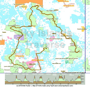
accompanying map highlights some of the major attractions along the route, which
include:
| |
| SKIT
3D Map - click for full-size
|
-
10
of the Sky Island ranges* (Dragoons, Huachucas, Santa Ritas, Rincons, Santa Catalinas,
Galiuros, Santa Teresas, Pinalenos, Dos Cabezas, and Chiricahuas)* -
10
officially designated Wilderness areas, six of which are administered by the US
Forest Service, three by the Bureau of Land Management, and one by the National
Park Service. -
The
east district of Saguaro National Park (which includes the Saguaro Wilderness) -
Fort
Bowie National Historic Site (administered by the National Park Service) -
Chiricahua
National Monument (accessible via a short trip off the main route)
*
The map (see below) implies approximately 100,000 feet of elevation gain in 520
miles of walking, for an average gradient of 3.6%. (The GET, by comparison, has
~110,000' in 730 miles, a 2.8% average gradient; the venerable Appalachian Trail:
4.5%.)
San
Pedro Riparian NCA The
San Pedro River remains one of the Southwest's last undammed, free-flowing streams,
and is especially unique given its perennial course through the low country of
the Chihuahuan-Sonoran desert eco-region. This important riparian corridor is
also home to more than 250 species of native and migratory birds. An extended
portion of the river between the Mexican border and community of St. David, Arizona
is protected as the San
Pedro Riparian National Conservation Area. This corridor provides a natural
travel route between the surrounding ranges and in no small way makes a link between
the Dragoons and Huachuca Mountains possible. Linking
it all together
| |
| Land
Ownership map, with elevation profile - click for full-size
|
The
520 mile long Sky Islands Traverse (SKIT) also receives help in no small part
from the Arizona Trail (AZT)
and Grand Enchantment Trail (GET), the two established long-distance routes that
thread this region. Other on-the-ground resources—various trails and roads—permit
connections between the two big routes and beyond. Occasional stretches of cross-country
travel also facilitate passage, and a few of these, as mapped and explored to
date, are fairly "out there" by long-distance hiking standards, even when compared
with the CDT and GET. These are outliers in the course of the adventure, which
is more moderate overall, but are real challenges all the same, approachable with
the right attitude and hiking skill set (and avoidable only at the cost of greater
inconvenience, or so it seems as of this writing). Once
in the Huachuca Mountains, the SKIT joins the Arizona Trail, next crossing the
Santa Rita Mountains, with a brief diversion here in order to spend more time
along the high crest of this rugged range. The route then remains faithful to
the Arizona Trail until the Wilderness of Rock region of the Santa Catalinas,
where the SKIT strikes out eastward in order to explore challenging and spectacular
Redfield
Canyon as well as the Galiuro
Mountains, here trending northward toward a rendezvous with the Grand Enchantment
Trail at the lonely outpost of Klondyke. The SKIT coincides with the GET over
the Santa Teresa Mountains and across the Pinalenos (aka the Grahams), then heads
off on its own once more as the pioneering journey continues south across what
might be termed the Pinaleno-Chiricahua Divide. Here begins perhaps the most adventurous
portion of the journey, as the SKIT traverses a region little-explored and notably
lacking in established trails, though certainly wild, remote, and scenic. The
Dos
Cabezas Mountains Wilderness might be considered the heart of this untamed
country. Farther along the SKIT reaches Fort
Bowie National Historic Site, where it follows the historic Butterfield
Stage Route for a time. A bonafide trail network, somewhat vestigial initially,
does return as the route reaches the Chiricahua Mountains proper, then blossoms
into a landscape of recreational bounty as it passes the famed rock formations
of Chiricahua National
Monument and on into this range's high country wilderness. The Sky Islands
Traverse ends at a windswept fire lookout atop Silver Peak, towering above the
birder's paradise of Cave Creek Canyon, sometimes called the Yosemite of the Southwest,
just outside the surpassingly scenic village of Portal, as
seen here.
Approach & Philosophy
My
own journey along the Sky Islands Traverse, in March and April of 2010, unfolded
in traditional long-distance hiking style. My intent was to walk a continuous,
unbroken route between the SKIT's termini, and to resupply along the way via postal
maildrops and/or stores. Resupply opportunities—around 8 all told—are
fairly abundant in near-to-trail towns, especially in the first half of the trip;
indeed I was able to forgo some of these in favor of extending my time in the
backcountry. Although distances between water sources along the route may occasionally
prove inconvenient, I was always able to find water more than once a day given
the prior winter's average-to-above-average precipitation, and did not need to
rely on pre-arranged caches. While
the lead-up to this trip in many ways resembled the time I spent planning my first
walk of what I later came to call the Grand Enchantment Trail, it was also distinct
from that, as was the nature of the journey itself. I intentionally tried to avoid
putting too fine a point on this project prior to actually walking the walk, having
learned that reality "on the ground" is so often impossible to predict, and best
approached with a nimble attitude rather than a fixed itinerary and mindset. Rather
than trying to nail down every last detail before setting off, I tried instead
to direct my focus on simply getting out there and exploring this remarkable Sky
Island region, to learn what the land has to teach, and to behold what remnants
of vitality it continues to possess in this time of ever-expanding human influence
on the natural landscape. Granted, plenty of effort went into making a "best
guess" route layout beforehand, and I was fortunate to find that my plan
worked reasonably well. Many portions of the mapped route met or exceeded expectations,
while others were passable if less than ideal (or perhaps the better for it, from
the standpoint of having a healthy adventure!). A few of my ideas proved to be
misguided, although nothing along the way presented a genuine impasse, and only
weather-related concerns narrowly prevented me from completing the full thru-hike.
Ultimately my intent was to embrace all parts of the experience, and the process,
as necessary components of any worthwhile and rewarding adventure. With the right
attitude, and the good fortune to avoid injury and illness, it seems that success
in some form is always guaranteed on these pioneering journeys and is ours alone
to define and ultimately to savor. The Sky Islands Traverse is in many ways just
a blueprint, a trail map for personal discovery, and there are many ways to reach
that destination.
Additional Resources
Photo Journal
A
collection of 800+ images from the Spring 2010 exploratory hike, organized by
section. Place names, features, and trails listed in the section descriptions
are ordered chronologically as encountered during the trip, and are intended to
offer a general sense of the chosen route. Detailed captions beneath each photo
tell the story of the hike as it unfolded day by day. Click
here to go to the photo journal.
Interactive Google Map In
addition to the Sky Islands Traverse overview maps on this page, the interactive
Google Map below offers further perspective on the route. Google Maps lets you
view multiple map types, including detailed topo maps, terrain and street maps,
as well as satellite images; there's also an embedded Google Earth layer for three-dimensional
viewing. The route line shown here represents a composite of what I walked and
what I would walk were I to do the hike again. Probably 90% or more of the route
line represents my walk, and the rest are portions of my intended walk that I
missed due to snowpack concerns or are my proposed "better options"
to what I walked due to difficulties encountered or ideas for improvement. (In
a few cases better options have yet to be identified!) Suffice it to say this
would be the most advanced template to start with if planning such a hike for
yourself.
Mouse-over
map to interact. For topo map, select MyTopo from dropdown menu at right.
Click here to view map in a separate, resizable window (with Data Book waypoint
locations).
Special thanks to Postholer.com for facilitating the Google Map
|
Google Earth KML
View
the route directly in the Google Earth standalone app using the file below. All
you'll need is
Google
Earth on your desktop. Then just click on the following link to launch the
file. (Or right click > Save As.) Overlayed on Google Earth's seamless, high-detail
satellite imagery, it offers an astonishingly realistic and informative look at
the terrain through which the route passes.
 sky-islands-traverse.kml (v1.0) sky-islands-traverse.kml (v1.0)
GPX Tracks & Waypoints
The
same data presented in the Google Earth file above is also available in GPS eXchange
Format (GPX). Three separate files are available for download: a GPX track for
displaying a trace of the route in mapping programs like TOPO! (Arizona state
series) and TopoFusion, a somewhat less data-rich track formatted specifically
for uploading to a GPS unit, and a waypoint file with points of interest and mileages
that can be used both in mapping programs and GPS devices. Click on the following
links to download the files (right click > Save As.)
| Disclaimer:
Use of these files is solely at the user's own risk. This data is intended for
informational purposes only and does not represent an endorsement of a specific
route. Hike your own hike. | | map
data track
(v1.0) | Detailed
trace of the route described by 13,000+ data points. Loads as a collection of
8 tracks, divided by suggested resupply sections. (In TOPO!, import the tracks
as "freehand routes" rather than waypoints.) | | GPS
track (v1.0) | GPS-friendly
track file of the entire route with 10,000 data points. (Loads in a GPS unit as
20 tracks of 500 waypoints each.) | | waypoint
file (v1.0) | Nearly
470 waypoints describing specific points of interest along the route. Waypoint
names are actual milepoints (example name: "MP10.5") and are keyed to
data book entries (see Data Book section below). * |
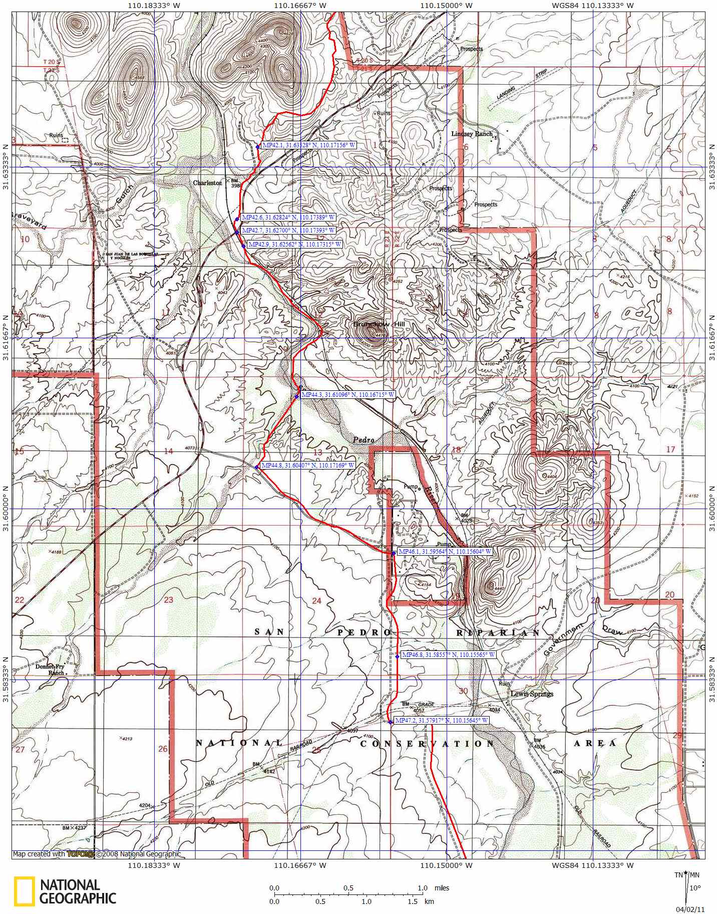
| |
| sample
map using TOPO! - click for full-size
| Notes
on the Map Data Track and Waypoint File:
These two files can be imported together into TOPO! (Arizona state series) to
create a detailed mapping resource. In Preferences > GPS > Waypoint Display,
select 'Show Both Name and Coordinate' to see waypoint names (which are milepoints
along the route) and their corresponding GPS waypoints. This information will
be superimposed on the SKIT route line (trail trace) and base map data, and you
could then print something akin to field-worthy topo maps. Click the thumbnail
at right for an idea of what to expect. *
Regarding the waypoint file, some GPS units won't accept a decimal point in a
waypoint name (e.g. "MP10.5"). In this case, the decimal point can be
changed manually to the well-accepted "-" (en dash) symbol using find
& replace in a text editor. You can also get around this problem when importing
the waypoint file in TOPO! by first selecting one of the newer GPS receivers in
Preferences > GPS > Receiver Type. Note, too, that all of the waypoints
in this file, just like the GPS track file data, have been derived from mapping
software and will most likely be a little off vs. reality in the field. Mileages
(ie, the waypoint names) are the same as those listed in the Data Book (see below)
and are based on an adjusted total trail length of 520 miles. This figure is around
5% longer than the total trail length indicated by the map data track (trail trace)
and should help to correct for computational errors and provide more realistic
mileages between points.
Sky Islands Traverse Data Book
Everyone
loves a good spreadsheet. This one attempts to combine as much useful data as
possible in one place, and includes nearly 500 data points highlighting which
trails and tracks the route employs, along with mileages, elevations, important
junctions, water source and resupply locations, and other points of interest along
the way. Most locations listed in the Data Book are paired with waypoints in the
GPX waypoint file (see above) and the two can be cross-referenced by milepoint.
(This should become obvious once you load the waypoint file in TOPO! See the above
map for an example. The idea is to be able to print and carry the maps alongside
the Data Book and to use the two resources together for planning and navigation
in the field.) All
locations in the Data Book are also paired with waypoint locations displayed on
the Google
Map, for handy visualization. Locate a feature of interest in the Description
column on the chart, then click on its link to see that data point (including
GPS waypoint in decimal degrees) highlighted on the map. Download
the Data Book as a PDF file via the link below (right click > Save As). Or
click
here to view it online at the postholer.com website. The PDF version of the
Data Book will eventually be expanded to include more info to help with navigating
the route, links to websites with trail descriptions, and more. Watch for version
1.1, available later in 2011. Data
Book (PDF) (v1.0) Special
thanks to Postholer.com for facilitating
the Data Book format.
Talk
Back
If
you happen to find the above resources useful, or if you have suggestions for
improvement, please let us know! We're not actively
encouraging others to hike the exact route layout as described, and are less interested
in fielding specific questions about planning and hiking it. On a route as undeveloped
as this, your hike should be your decision and responsibility, and this information
should only serve as a catalyst for having a rewarding and ultimately unique journey
across this remarkable Sky Island region. Happy adventuring!
For
more information about the greater Sky Island eco-region, and about the threats
it faces from human encroachment and climate change, please visit the homepage
of the Sky Island Alliance.
In particular, the Alliance's "state
of the Coronado" reports provide a wealth of information on the Sky Island
ranges overseen by the Coronado National Forest, including all of those encountered
on a journey along the SKIT. |
|