G.E.T.
Guidebook
Segment
7: Aravaipa Canyon Wilderness 12.8 miles
 Guidebook
Home Guidebook
Home
Open
this page for printing
Submit
feedback for this segment
|
Segment
Length | Segment
Status | Season |
|
|
|
12.8
mi. | finalized
& accessible | all
year | | Resources |
| OVERVIEW
MAP | 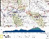 |
| ELEVATION
PROFILE |  |
G.E.T. Topo Maps 20-21
Water Chart
Image Gallery: Album 3
| Additional
maps:
Mammoth
1:100K (BLM)
Brandenburg Mtn (USGS)
Booger
Canyon (USGS)
Land management agency:
(Aravaipa Canyon permits)
BLM Safford Field Office
Brandenburg Ranger Station
Klondyke Ranger Station |
| Beginning
access point | | Ending
access point | |
Aravaipa Canyon Wilderness
west trailhead. (NOTE: An Aravaipa Canyon Wilderness use permit
must be obtained before arrival here if entering the Wilderness. See Segment
Overview below.) 10 mi N of Mammoth, or 11 mi. S of Winkelman, turn east off AZ
Hwy 77 onto paved Aravaipa Road, which becomes graded dirt in ~4 mi. (Portions
of this road serve as the main GET route in Segment 6.) Continue past the Brandenburg
BLM ranger station (9 mi.) to the large dirt lot at the end of Aravaipa Rd., 12
miles from the AZ 77 turnoff. No camping allowed at the trailhead or surrounding
Nature Conservancy land. | |
Aravaipa Canyon Wilderness
east trailhead. (NOTE: An Aravaipa Canyon Wilderness use permit
must be obtained before arrival here if entering the Wilderness.
From I-10 at Willcox: Take Exit 340 north (left) toward Bonita along the
Ft. Grant Road. At the "T" in Bonita, turn left and go 38 miles to the East trailhead
on graded dirt Aravaipa Canyon Rd.
From US 70 at Safford: Take US
70 west past Pima and turn left on Klondyke Road (turnoff marked Aravaipa Rd).
On this graded dirt road, go 24 miles to the "Y" intersection, turn right and
go another 16 miles to the trailhead, which is near the junction of Aravaipa and
Bear canyons.
NOTE: Several shallow crossings of Aravaipa Creek are normally
encountered within the last few miles to the trailhead. |
SEGMENT
OVERVIEW Aravaipa
might well be considered Arizona's "Grand Canyon of the Sonoran Desert." For like
its neighbor to the north, Aravaipa Canyon is also a place born of water, uplift,
and erosion - a great curving and carving of the land into a sheer-walled labyrinth
of light and color, liquid and life. In terms of geography, this grand canyon
is small - a fifth as high, its main passage walkable in just a day or two. Yet
by measure of its life, Aravaipa is a place of rare grandeur. Its perennial creek,
fed by subterranean waters from past Ice Ages, harbors more native species of
fish than any low country stream in Arizona. Aravaipa Creek and its tributaries
nurture some 1000 acres of diverse, deciduous riparian forest. Mountain lion and
bobcat hunt here, their prey including bighorn sheep, javelina, and coatamundi,
in addition to white-tail deer. One hundred and fifty species of birds have been
recorded in the canyon, including the large, unmistakable Great Blue Heron, a
common and striking sight in this desert land. For just beyond the leafy shade
at creekside, the saguaros, chollas, and prickly pear of the Sonoran Desert take
hold once more, clinging to buff brown slopes worn sheer by the work of time.
The above synopsis
was written prior to the devastating flood of summer 2006, which tore through
the canyon with a force powerful enough to uproot full-grown cottonwoods and other
native shade trees by the thousands, in some cases depositing them miles downstream.
Much of Aravaipa Creek's riparian corridor was destroyed, opening the canyon bottom
to the desert sun and, in an ironic turn, enhancing the canyon's scenic quality
by permitting unrestricted views of the surrounding cliffs. Anyone fortunate enough
to have experienced the canyon pre-flood will in many ways find it unrecognizable
now, so much was the focal point before on the narrow string of verdant splendor.
Yet this canyon is nothing if not resilient; the "river forest" will grow back,
as it has done in the wake of similar floods before (a generational event, history
shows). And in this warm, sunny climate, recovery in the presence of a perennial
stream is comparatively quick. Indeed the forest was already regenerating quite
nicely as of this writing, some 7 years later. Now
as before, Aravaipa Canyon remains a pristine riverine ecosystem due to its designation
as a BLM Wilderness area. The BLM does not maintain trails in the canyon in favor
of "dispersed impacts" to the environment. In spirit, this is a cross-country
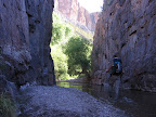
hiking experience - one walks along the bank of Aravaipa Creek until the canyon
bends, then crosses to the other bank, and so on. Social trails did exist before
the flood, worn down by hikers as paths of least resistance along the banks. And
these trails are now on their way back as the creekside understory, grasses and
rushes fill in. Just as often, though, you'll be following the path of least resistance
along sandy, rocky, and occasionally debris-choked corridors between the creek
and canyon walls. Sometimes it may seem easier just to slosh up the creek itself
- it's usually only ankle or shin-deep, somewhat quick, but easily negotiated
(except in flood, of course, when you should definitely avoid the canyon). Finding
an efficient line of travel is half the fun and most of the challenge in Aravaipa.
Expect a pace no faster than 1-2 mph along with numerous creek crossings (perhaps
one every quarter mile or oftener) and continuously wet feet. All things considered,
conditions really aren't that bad nowadays; unavoidable blowdowns may need negotiating
here and there, and some "quicksand" may be present (and avoidable), but hiking
times to traverse the entire canyon remain essentially unchanged. In
any case, the business side of raw, pristine wilderness in the case of Aravaipa
Canyon is the permit system. Everyone entering the canyon must have one: day hikers,
thru-hikers, overnight campers all. This business is complicated by the fact that
permits are limited in number, must be reserved in advance, and once paid for
cannot be modified. Business appears to be good, though. The Canyon (and probably
afterward, you too) will appreciate the patronage... and native solitude. See
the GET Trek Planner chapter on Permits for
more info. TRAVEL
ALERT: Because the main route of the GET
in this segment (7) runs through Aravaipa Canyon Wilderness, hikers intending
to access this segment, eastbound or westbound, and who are unable to obtain the
requisite permit to enter the wilderness, MUST detour around Aravaipa Canyon.
Read ahead to the Aravaipa Canyon Bypass North route described at the end
of this chapter. Do not under any circumstances attempt to hike Aravaipa Canyon
without a permit, or with an off-schedule permit. Otherwise the BLM ranger on
duty WILL find out and you'll ruin it for the rest of us. Fines are steep too.
See the GET Trek Planner chapter on Permits
for more info.
ROUTE
DETAILS At
the west trailhead at the end of Aravaipa Road, sign the register (enter your
permit number) then follow signs toward Aravaipa Canyon Wilderness. A rocky trail
at right soon leaves the wide track (which ends just ahead at the former ranger
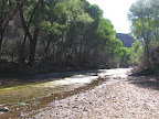
residence once used by Edward Abbey). The trail descends to reach once-sycamore-and-cottonwood-shaded
Aravaipa Creek at 0.2 miles (elev.
2600'). You'll find some trees still standing, though, as well as a notable regeneration
of riparian vegetation since the flood. The next mile is located on land owned
by the Nature Conservancy, where camping is not allowed. A use trail initially
crossed Aravaipa Creek to follow its south bank, then returned to the creek, and
it appears hikers are still going this way. Here you could ford then look for
a resumption of social trail or else walk up the creek itself - the standard options
here in Aravaipa. Keep right, where signed, skirting an off-limits area by a former
ranch house just north of the creek. Reach the BLM Wilderness boundary at 1.4,
beyond which dispersed camping is permitted. Progress
within Aravaipa Canyon is most easily gauged by way of its side canyons (which,
it's worth noting, were largely unaltered by the floods and remain more biologically
intact). These side canyons appear at fairly regular intervals, left and right
as you progress in the main drainage, although some are easy to overlook. Pass
a narrow side canyon called Hell's Half Acre on the right (south bank) at 2.0,
which you can explore a short ways to a boulder-choked pour-off - an impressive
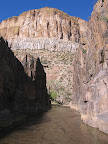
reminder of the power of moving water. Ahead, the main canyon briefly narrows
into a sheer-walled box composed of dark red schist, where you are forced to walk
in the creek itself. Watch out for areas of quicksand here - it won't pull you
under, of course, but can be difficult to walk out of. Javelina
Canyon, on the left at 3.5, often pours forth a small flow of water. The
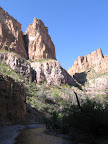
main canyon floor widens somewhat now, while orange and buff-colored cliffs of
ash-flow tuff soar to more than 1000 feet above the creek. The scene is perhaps
most impressive approaching Virgus Canyon at 4.6. Good campsites among
the bordering cottonwood groves may still be found in the vicinity of this tributary.
More forested camps are also ahead within the next mile, mostly along the south
bank. En route, pass the side drainage of Horse Camp Canyon on the left (5.0,
waypoint 07080), with a refreshing plunge pool less than a quarter mile away along
its course, the perfect respite on a warm afternoon. Booger
Canyon joins from the left at 6.5, while the high walls of Aravaipa Canyon
- comprised, collectively, of the Galiuro volcanics group - now diminish somewhat,
permitting a sunny mesquite forest just above the riparian creek environment.
The geology of the canyon changes near Hell Hole Canyon at 8.5, where distinctive,
cobbly conglomerate cliffs appear eastbound, rising sharply from the canyon bottom.
Hell Hole is perhaps the most rewarding of Aravaipa's tributaries to explore,
as it remains navigable (without impassable pour-offs) for several miles, its
slot-like passage narrowing at times to under 20 feet. Be careful not to take
sandy-floored Hell Hole Canyon by mistake, though, as Aravaipa Canyon bends sharply
toward the south at the confluence (waypoint 07100). Reach
the east boundary of Aravaipa Canyon Wilderness at 10.8, (waypoint 07120,
elev. 3050') where the canyon of Turkey Creek converges from the south. Eastbound,
you have two options here. TURKEY
CREEK ALTERNATE ROUTE: This alternate route, described in Chapter 8, follows
sometimes-dry Turkey Creek (where free, permit-less camping is allowed), passing
a well-preserved Salado cliff dwelling in 1.3 miles. The alternate route eventually
leaves Turkey Creek to follow 4WD roads over to Fourmile Canyon where it continues
to Klondyke Road at Klondyke, 2.4 miles south of the main GET route. The alternate
route is a good option for hikers planning to resupply at Klondyke then continue
around the Santa Teresa Wilderness on the south side (via the Buford Hill alternate
- see Seg 8). And of course, westbounders without a permit to enter Aravaipa Canyon
Wilderness can bypass the canyon via Turkey Creek and the Rug Road, as described
in Segment 6. MAIN
ROUTE: From the confluence at 10.8 continue east in Aravaipa Canyon
via 4WD Aravaipa Canyon Road, soon entering Nature Conservancy land once more,
where camping is not allowed. A few long-adandoned homesteads soon appear at roadside,
a peaceful and contemplative scene. Prior to the flood the option existed to either
follow the road or take a meandering trail that eventually returns to it, but
the flood destroyed the trail and the Nature Conservancy has since signed the
area as off-limits (so just remain on the road). Slosh across Aravaipa Creek a
few more times via the road, watching for coatimundi among the once-again lush
forest canopy, then reach a junction with Bear Canyon and its 4WD road at left.
Eastbound, take the right fork (westbound, left fork) and momentarily arrive at
Aravaipa Canyon Wilderness east trailhead, at 12.8 (elev. 3190'), with
vault toilets as well as a sign-in register for westbound travelers entering the
Wilderness.
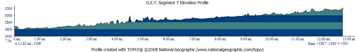
| ELEVATION
PROFILE | 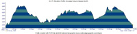 |
ALTERNATE ROUTE:
ARAVAIPA CANYON BYPASS NORTH Hikers
who find it necessary to bypass Aravaipa Canyon Wilderness - for instance, to
avoid dealing with the permit system, or when permits happen to be unavailable
or you're off-schedule - can instead follow this bypass route. But please note:
Because Aravaipa Canyon cuts deeply into a rugged mountain range - the Galiuros
- which otherwise presents a barrier to east-west progress, few roads or trails
cross the range nearby. This alternate route does run closer to the canyon than
the other bypass option that goes through Mammoth, and is much more of a backcountry
hiking experience overall, though it too is unavoidably roundabout, and thus 12
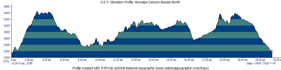
miles longer than the main GET route. The
Aravaipa Canyon Bypass North begins at mile 6.8 of the main route in GET Segment
6, and ends at the Aravaipa East Trailhead outside the Wilderness area (GET Segment
7 mile 12.8). Total length of the alternate route is 29.5 miles, again making
it about 12 miles longer than the portion of the main route it replaces. This
alternate is located mainly on old 4WD roads that see very little (or no) use.
The road network takes the hiker on an adventurous tour along benches and side
canyons north of Aravaipa Canyon, sometimes over slickrock, or past ruins of old
ranches. Water is seasonally available in a number of stock ponds (dirt tanks),
a few of which may be fairly reliable, though it is probably wise to carry more
than you think you'll need. You may also find water in rock pockets or in the
major drainages that feed into Aravaipa, including Cave and Javelina canyons and
especially Horse Camp Canyon, the western fork of which our route crosses without
the aid of road or trail, a brief route-finding challenge to negotiate. It's
important to note that although the alternate route occasionally passes into Aravaipa
Canyon Wilderness (the boundaries of which are shown on the mapset in yellow),
it does so without entering the zone where a permit is required. Specifically,
all areas of the Wilderness outside of Aravaipa Canyon proper and its side canyons
as accessed from Aravaipa Creek, in their drainages, are considered to be outside
the permit zone. This means that within the Wilderness, one could walk over to
the edge of Aravaipa Canyon, from above, and behold this incredible landscape,
with no permit required - and in fact this is quite possible, as the mapset shows
an opportune point to venture over to the rim from the road network along this
alternate route. What one cannot do is to hike down Aravaipa's side canyons from
the alternate route all the way to Aravaipa Canyon proper and the permit zone
there. In practice, this isn't a viable option anyway, as all side canyons feature
barriers to travel such as pour-offs. So stick with the alternate route and enjoy
the uniquely wild feel of this little-known above-the-rim environment. As
of early 2018 the Aravaipa Canyon Bypass North route has not been fully vetted
in the field. The route has been examined extensively via maps and satellite imagery,
however, and some in-person exploration may occur later this winter. Are you confident
in following a route of this nature? If so, then the rewards are surely here as
well. If not, then your best bet may be to take the other alternate route that
runs through Mammoth and along the Rug Road into Turkey Creek, which is described
in Chapter 6. In any case, a fuller, mile-by-mile description of the Aravaipa
Canyon Bypass North route will be available here in the future. |