G.E.T.
Guidebook
Segment 18: Sunflower Mesa 9.7
miles  Guidebook
Home Guidebook
Home
Open
this page for printing
Submit
feedback for this segment
|
Segment
Length | Segment
Status | Season |
|
|
|
9.7
mi. | finalized
& accessible | all
year | | Resources |
| OVERVIEW
MAP | 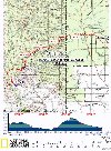 |
| ELEVATION
PROFILE | 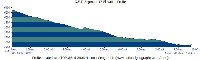 |
G.E.T. Topo Maps 48-50
Town Guide: Glenwood / Alma
Water Chart
Image Gallery: Album 5 |
Additional maps:
Gila National Forest
(USFS)
Land management agency:
Gila NF Glenwood Ranger District
|
| Beginning
access point | | Ending
access point | |
FR 712 at Trail 307 Trailhead.
4.5 miles north
of Glenwood NM, just south of where the highway crosses Mineral Creek in Alma,
(at signed Mile 46) turn west off US 180 onto a graded dirt road. The road crosses
the San Francisco River - often shallow or dry here, otherwise requiring a high-clearance
vehicle. (An alternate bridged crossing via County Route 004 is accessed 1.2 mi.
S on US 180 from mile marker 46. See the GET mapset for an overview.) Keep left
at the first junction beyond the ford, then right at the next junction, here joining
County Route 004. In 2.4 mi. from US 180, keep straight at a t-junction with a
road at left. In about 6 mi. from US 180, past a power transmission line, turn
right (onto FR 712, which may require 4WD when wet). A sign here says "Sunflower
Mesa." Continue 3.8 mi. to the AZ/NM boundary at a fenceline. Primitive parking
is available on either side of the fence near the signed trailhead for Charlie
Moore Trail #307. Please
note: These driving directions follow the route of the GET for its entirety
in this segment. | |
US 180 at Alma. Short-term
parking may be available in the village of Alma, located 4.6 miles north of Glenwood
along US 180. Ask at the Alma Trading Company, a general store, the community's
only storefront. (The GET crosses US 180 less than 0.1 mile south of the store.)
Otherwise, consider parking at the trailhead for Gold Dust Trail #41, at the east
end of Segment 19, and hiking these two segments together. (See the "Ending
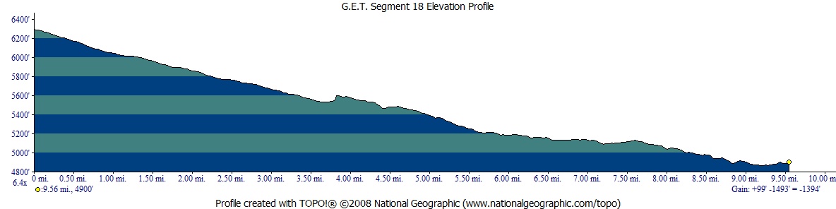
access point" for Segment 19.) | SEGMENT
OVERVIEW Along
with Segment 19, this short segment offers a convenient link between the backcountry
of Arizona's Blue Range and the Gila Wilderness in New Mexico. US 180 serves as
a natural dividing line between these segments, and at 4900 feet is also the lowest
point along the eastbound GET until the Rio Grande valley some 250 miles away.
(Long-distance hikers heading westbound will commonly encounter lower elevations
in Arizona.) The 2-lane highway offers access to the village of Alma,
directly along our route, and also somewhat larger Glenwood
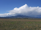
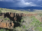
a few miles to the south. Sunflower
Mesa is one of several broad volcanic plateaus that slope eastward from the Arizona
border toward the valley of the San Francisco River near Alma. The landscape is
quintessential New Mexico: wide open, with far-flung mountain vistas, and an austerity
that invites contemplation. The GET in this segment follows graded Forest Service
roads, offering easy walking and straightforward navigation. Besides the occasional
rancher or hunter driving by, you're likely to have these roads to yourself. Although
Sunflower Mesa would be considered prime range land, in fact it is not grazed
by livestock as often as elsewhere. Water is quite scarce, confined to a few scattered
earthen stock ponds, all of them unreliable. Plan to fill your bottles at the
end of the segment, in Alma or perhaps from the river. The single crossing of
the San Francisco along FR 106 presents no challenges most of the time, and in
many years the river here runs dry by late spring.
ROUTE
DETAILS Forest
Route 712 terminates at the trailhead for Charlie Moore Trail 307. Pass through
the gate in the north-south fence (waypoint 17180, elev. 6300'), leaving Arizona
and the Apache National Forest to enter New Mexico and the Gila National Forest.
(Note that New Mexico observes Daylight Savings Time, while Arizona does not.
Eastbound, set your watch one hour ahead during DST.) Follow the road that heads
southeast, away from the fence. In about 0.1 of a mile (waypoint 18010)
another road joins from the right and heads back to the border at a metal tank
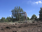
(likely dry). Stay on FR 712, which now turns northeast. First though, pause for
a photo at the "border monument" here at the junction. The mileage listed
on the sign seems to be a bit off the mark. The
surrounding terrain becomes ever less rocky as you proceed along Sunflower Mesa.
Remarkably, the state line is almost precisely the end of the GET's cobbly, volcanic
terrain, the standard fare underfoot since Safford environs. Pass a couple of
tanks / troughs within the first mile; the one at around 0.4 - a 500
gallon tank - was noted in 2013 to have a faucet that dispensed spring-fed
water into the trough, but has been dry of late. Cross a cattle guard along the
road at 0.9. then at around 1.4 a thirsty hiker could leave the
road on a cross-country bearing for Pit Tank
(waypoint 18025), located 0.3 of a mile due north near the head of a side drainage
of Beaver Canyon. (This earthen tank was observed on satellite imagery to be wet
and of apparently decent size and quality in May of 2014 (drought conditions),
while other tanks along the mesa were dry or of poor quality at that time.) The
junipers continue to decrease in size and number with the elevation, until only
grama and other short grasses remain. Fall hikers may also confront a phalanx
of the mesa's namesake sunflowers nodding at roadside (the surrounding terrain
is sometimes densely carpeted with smaller yellow flowers at this time of year
- not sunflowers - and can be a sight to behold). As
of 2015 a small, float-valve-controlled trough
was located at roadside around 3.0, full upon first observation. Here again,
don't count on these ephemeral rancher improvements, which have a poor record
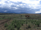
of reliability in this area. Sunflower Mesa Road comes to a prominent t-intersection
with FR 105 at 3.8. Turn left (north) at the unsigned junction. FR 105
bends clockwise as it climbs a low hill and passes beneath a pair of tall power
transmission lines. The prominent lone peak off to the northwest is Whiterocks
Mountain. To the east you may note snow in springtime atop the Mogollon Mountains,
here in plain view across the San Francisco River valley. A full moon rising over
those mountains from this vantage is an experience the author won't soon forget. Follow
graded FR 105 gradually off the mesa, noting the return of junipers, as the increased
slope angle must favor them as it does other drought-tolerant vegetation. At 5.7
(waypoint 18050) turn left (east) by the entrance to a private ranch. Cross the
dry, but cottonwood-nourishing wash of Vigil Canyon at 6.6. Just beyond,
a convenient, if decidedly front-country, camp could be made near the lone live
oak at left (this is Gila National Forest land, after all). The wash may sometimes
flow where the canyon narrows to the east. Note on the map where the road comes
close to the sycamore-lined drainage again, where you can clamber down the bouldery
embankment in search of small pools among
the rocky-strewn drainage bottom. (More secluded camping is possible in the drainage
here.) Keep straight at 7.3, now on FR 106 (C004), which also heads right
(south, as C003 / Smoothing Iron Rd). (Note that the roads in this area are referenced
by county route number - on signs and some maps - and also by forest route number.)
Ignore a lesser
road that forks right at 7.9 and continue
on graded 2WD FR 106 to a prominent fork at 9.0 (waypoint 18080). The
GET heads left here onto signed C017, but hikers planning to walk into Glenwood
for resupply can instead continue straight (southwest) on C004 to US 180, thereby
cutting off about a mile of the highway walk. A bridged crossing of the San Francisco
River along this detour also facilitates safe passage during high water, whereas
the main GET route confronts the river directly (see next). (One can access the
river from the northwest corner of the bridge, to collect water when it's flowing,
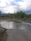
etc.) The main
route descends to a junction with FR 104 (C008, waypoint 18090). Turn right and
continue a short ways to cross the drainage of the San
Francisco River along the roadway. In the wet spring of 2005, the ford
was 25 feet wide and shin deep, while in the fall of that same year the river
was entirely dry here. Following the 2012 Whitewater-Baldy Fire in the Mogollon
Mountains and subsequent 2013 catastrophic flooding, the river filled with a large
volume of sediment and may in fact be dry at the surface here now more often than
not. Continue east among pastureland, crossing a cattle guard just before reaching
US 180, at 9.6. Turn left (north) and walk the paved, 2-lane highway's
shoulder on a bridge over Mineral Creek. The
segment ends a short ways beyond, at a junction with Mineral Creek Rd on the right
(9.7, waypoint 18110, elev. 4900'). The Alma Grill is nearby, as well as
the adjacent Alma Trading Company, which has bottled
water for sale and also an outside spigot.
To visit either, head 100 yards north along Highway 180. |