 WINSTON
NM WINSTON
NM
Trail
miles from west terminus: 465 via
Hwy 59 & 52 /
494 via
Hwy 52
Distance from GET: 24 miles SE / 18.5 miles S
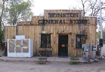
Winston
is a near ghost of a former silver mining boomtown, located in the shadow of the
remote Black Range of the Gila National Forest. The town can be difficult to reach
from any direction, and you won't find much once you get here. However it's a
link to the outside world in this lonely corner of New Mexico, and a possible
resupply point for hikers who would prefer a sketchy hitchhike (via Hwy 59 or
Hwy 52) to the off-trail hiking often required to reach Monticello (see next entry).
From
the GET / CDT crossing of NM Hwy 59 in the Black Range, Winston is a ~24 mile
hitchhike via paved roads which receive only light vehicle use. Hwy 59 in particular
is very lightly travelled, most often by hunters or USFS personnel. Because of
the difficulty of hitchhiking from this remote spot and the lack of good options
if stuck here with an empty food bag, the following hitchhiking location is likely
preferable. From
the GET crossing of dirt, 2WD NM Hwy 52 near Dusty (scattered ranches/residences
in an emergency, but no services), Winston is an 18.5 mile hitchhike south. Traffic
is very light, though ranchers in the area do head into Winston to pick up mail.
Hwy 52 is paved south of its junction with Hwy 59. Chloride, located 2-3 miles
beyond Winston, is a refurbished, museum-like ghost town that may offer a rental
cabin but no restaurant option at this time.
Back
to GET Town Guide Home | 


 TOWN
GUIDE
TOWN
GUIDE