G.E.T.
Guidebook
Segment
6: Brandenburg Mountain 11.9 miles
 Guidebook
Home Guidebook
Home
Open
this page for printing
Submit
feedback for this segment
|
Segment
Length | Segment
Status | Season |
|
|
|
11.9
mi. | finalized
& accessible | fall,
winter, spring | | Resources |
| OVERVIEW
MAP |  |
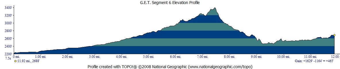
| ELEVATION
PROFILE |  |
G.E.T. Topo Maps 14-19
Town Guide: Mammoth
Water Chart
Image Gallery: Album 3
| Additional
maps:
Mammoth
1:100K (BLM)
Land management agency:
(Aravaipa
Canyon permits)
BLM Safford Field Office
/ Brandenburg Ranger
Station |
| Beginning
access point | | Ending
access point | |
AZ
Hwy 77 at Aravaipa Road. The GET crosses
the highway without vehicle parking amenities nearby. Instead follow Aravaipa
Road 0.5 mi. east to the small Central
AZ College Aravaipa Campus, where short-term
parking should be permissable (note the entrance gate may be closed at night &
on weekends / holidays - inquire within). For alternative parking, continue on
Aravaipa Rd (via the GET in Seg 6) an additional 1.8 mi. and turn left at a "no
dumping" sign onto a primitive dirt road (cars ok with care). This road passes
through a clearing then shortly reaches a gate. Park off the road before the gate. | |
Aravaipa Canyon Wilderness
west trailhead. (NOTE: An Aravaipa Canyon Wilderness
use permit must be obtained before arrival here if entering the Wilderness
in Segment 7. See Chapter 7 of this guide for more info.) Turn east off AZ Hwy
77 onto paved Aravaipa Road, which becomes dirt 2WD in ~4 mi. The GET route in
Segment 6 rejoins the road near the BLM Brandenburg
Ranger Station (free campsite & parking available here, first come first served).
Continue past the Ranger Station 3 miles to the large dirt lot at the end of Aravaipa
Rd., 12 miles from the AZ 77 turnoff. No camping allowed at the trailhead or surrounding
Nature Conservancy land. | SEGMENT
OVERVIEW The
main purpose of this segment is to connect the San Pedro River valley with Segment
7's Aravaipa Canyon Wilderness, which eastbound thru-hikers have no doubt been
anticipating. Section hikers arriving by vehicle may be tempted to drive straight
to the Wilderness trailhead at the east end of this segment, bypassing Segment
6 entirely. Aravaipa Road heads directly there, after all, and with only a few
bumps in the track. Look a little closer, though, and one discovers that this
segment has a good deal more to offer than at first meets the eye. Formerly routed
rather awkwardly in the wide, sandy flood plain of lower Aravaipa Creek's wash,
this portion of Seg 6 has since been realigned to provide more efficient and aesthetic-minded
travel, much of it on the opposite (north) side of Aravaipa Road and located some
miles away from it. Here the route follows a rugged yet straightforward network
of little-used dirt tracks leading into surprisingly desert-verdant foothills
of the Galiuro Mountains. Primitive camping opportunities, as well as seasonal
water, are encountered along the way. Climbing higher, the fiery-hued volcanic
cliffs of Brandenburg Mountain, a prominent local landmark, loom near as we transit
its western shoulder, while views north and south down the spine of the 50-mile-long
Galiuros prove extensive. Here the route briefly joins foot trail - albeit humble
in character - on return to Aravaipa Road, then soon passes the ranger station
for Aravaipa Canyon Wilderness (see Segment 7 description regarding permit requirements
for that segment). An hour's ramble along this quiet unpaved portion of the road,
often within sight and sound of adjacent Aravaipa Creek, leads to the Wilderness
trailhead and the conclusion of Segment 6. After
completing this segment - let it be noted - you'll arrive at this trailhead from
Highway 77 having accrued nearly identical mileage on your backpack's trip odometer
as would any passenger car confined to the main drag. How's that for an efficient
hiking route... with an adventurous twist. TRAVEL
ALERT: Because this segment (6) ends at
the west entrance of Aravaipa Canyon Wilderness, hikers intending to continue
eastbound through and beyond the wilderness, and who are unable to obtain the
requisite permit to enter this area, MUST detour around the main route in Segment
7. There are two ways to do this: either follow the Aravaipa Canyon Wilderness
bypass route, (described at the end of this chapter and beginning at waypoint
05155), which detours widely around Aravaipa Canyon and runs through the resupply
town of Mammoth en route, or use the Aravaipa Bypass North route (described
in Chapter 7 and beginning at waypoint 06080), which stays closer to the canyon
on its north side and does NOT run through Mammoth, meaning you would need to
get a ride into town if intending to resupply.
ROUTE
DETAILS The
main GET route begins at the 4-way junction of AZ Highway 77, Old Camp Grant Place
(to the west) and Aravaipa Road (to the east) (waypoint 06010, elev. 2224'). Proceed
east on paved, 2-lane Aravaipa Road. Compared to Hwy 77, just crossed by hikers
arriving from Segment 5, this road is low-speed and traffic is light. A wide dirt
shoulder serves as an informal 2-track road for local ATV'ers, and should make
for a decent walk, away from the blacktop. An RV Park on the south side of Aravaipa
Rd is posted private property but in a pinch you could try asking nicely for water
at the host's residence. (South of the RV Park, close to the highway, lie the
mostly-vanished and otherwise hard-to-discern ruins of the pioneer-era Camp
Grant military installation, now all but buried along with any promise it
held prior to the infamous Camp Grant Massacre for which it's mainly remembered.)
Otherwise
continue on to the tiny Central Arizona College's Aravaipa Campus, on the left
at 0.5 of a mile, with a public restroom and
faucets around
the back side of the middle building. The campus cafeteria may be open to the
general public at certain times - inquire within. (CAC facilities may be off-limits
whenever the main gate is closed, typically at night, on weekends and holidays.) The
wide dirt shoulder persists until 1.3 (waypoint 06020), where a dirt gas-line
corridor crosses the road. One could optionally leave Aravaipa Road here, heading
north initially along the gasline track, then turning northeast and eventually
east, all the while keeping a fenceline on your left. The terrain is rather barren
but the walking should be quiet. Otherwise press on via Aravaipa Road to 2.3
(waypoint 06030) and turn left at a "no dumping" sign onto a dirt road. This road
passes through a clearing, narrows to a proper road, then arrives at a gate and
register at 2.5. Beyond the gate our route enters state trust land (not
for the first time nor the last), but here the road eventually passes through
private lands, thus the required sign-in. Although we won't be entering private,
it's probably a good idea for GET users to comply, but just write "hiking on state
land" rather than making any GET-specific references. (A trail name along with
your real name should tip off any GET'ers behind you.) Beyond
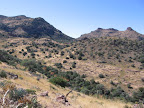
the gate at 2.5, the quiet jeep track ascends ever-so-gradually along the volcanic
pediment of the Galiuro Mountains, an expansive sky-island-like range with which
the GET dabbles just ahead, before passing straight through it in cross-section
via Aravaipa Canyon. The surroundings are classic lower Sonoran desert, becoming
increasingly lush as you go -- some of the palo verde trees are large enough to
offer welcome shade from the high spring sun. Along the way, pass a water cistern
and various ranching improvements, but no access to drinking water at last check.
At 4.9 reach a road junction by another cistern and turn right (east) onto
the lesser track. This track descends into a rugged wash at 5.3 (waypoint
06060) where the route then continues northeast in the wash itself. (Westbounders
be on the lookout for the dirt track leaving the right side of the wash at this
waypoint.) The
wash soon boxes up, with colorful, saguaro-studded hillsides above you -- a beautiful
setting, and a possible camp in dry times, along the banks here or there. You
may note the track exiting the wash briefly, then returning. Soon beyond, reach
a gate in a wire fence at 5.9. The suggested route of the GET heads through
the gate (which is posted as open for non-motorized use), or you could continue
up the box canyon a short ways in search of pools. (At last check AZ
Game & Fish had placed a wildlife camera a ways up the wash, which was obvious.
For the sake of their work, we're suggesting that GET'ers not walk past the motion-activated
camera. Return to the gate instead, beyond which our route soon crosses the wash
again, with another chance to find water, above the camera area.) A
rough track proceeds beyond the gate at 5.9, climbing sharply. Pass a lesser track
on the left, then keep right, descending steeply again on the abandoned roadbed
back into the box canyon. A lone cottonwood tree and tamarix bushes herald the
likely presence of water in this drainage -- for best odds, scout below the road
crossing to a little
bedrock pour-off.
(The named spring shown on the topo map is higher in this same drainage, probably
inaccessible.) The abandoned road climbs steeply up the opposite side -- use care
negotiating the sharp cut where it first leaves the drainage. (An easier route
out of the wash exists around the back side to your right, hidden from here, soon
meeting the main track again.) This
segment's namesake Brandenburg Mountain dominates the scene ahead of you. A well-known
local landmark, this peak will become ever more impressive the nearer it draws.
Meanwhile, the old road passes some long-forgotten ranching improvements, then
descends sharply into another wash. Beyond this wash it climbs to a little flat
and a junction -- ignore the track on your sharp right heading out to a point.
(Westbounders, keep right.) Reach a more definitive T-junction at 6.8
and turn right (east). (Westbounders, turn left.) (The Aravaipa Canyon
Bypass North route, described in Chapter 7, leaves the main route of the GET
here, for those without a valid permit to enter the Wilderness in the next segment.) After
dropping into yet another wash, the road climbs steadily to a second T-junction,
this one atop a viewful ridge (waypoint 06090, elev. 3400'). Pause here to soak
in the scene before you, with the sheer volcanic escarpment of Brandenburg Mountain
rising above peaceful, tree-lined Aravaipa Creek, and an alluring maze of peaks
and canyons to the south culminating in prominent flat-topped Table Mountain.
From this postcard vantage your destination is Aravaipa Road once more, and from
there a short, pleasant 3 mile dirt road walk to the Wilderness trailhead at segment's
end. We'll reach the road via foot trail, in fact. From
the ridgeline T-junction turn left (east) a short distance to a modest saddle
at 7.4 and look for a cairn marking the start of foot trail at right. (The
road continues along the Brandenburg escarpment, affording a peakbagging opportunity,
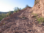
but the final push is reported to be a rough, cross-country affair.) The
unsigned trail is little-used but obvious enough to follow with care, as it does
a commendable job of descending through some very rough terrain. At 7.8
it reaches a wash, which it follows downhill. (Westbounders look for a cairn
on your right indicating where constructed foot trail leaves the wash: waypoint
06120.) From here, one simply follows the path of least resistance in the
drainage, which eventually widens into a washy thoroughfare of sorts -- watch
for the tracks of any recent hikers, especially birders in springtime, who access
the lower wash from the nearby ranger station. The wash reaches Aravaipa Road
at a sharp turn in the road at 8.7 (waypoint 06130, elev. 2700'). (Westbounders
note the obvious, wide wash on your right beyond the ranger station, possibly
with a carsonite post signed "no vehicles.")
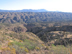
At
9.8 cross a scenic steel-truss vehicle bridge in the shadow of dramatic
redrock Brandenburg Mountain. The cactus-strewn cliffs contrast intriguingly with
the cottonwoods and exotic palm trees at quaint little ranches beside the road.
The creek is close by, though with the exception of one point of roadside access
near 10.5 it generally remains inaccessible on private land. At
length, the dusty road climbs to reach the trailhead parking lot for Aravaipa
Canyon Wilderness, at 11.9, the end of this segment. A sign-in register,
vault toilet, and self-service pay station are located here. Refer to Segment
7 of the guidebook for more information about Aravaipa Canyon Wilderness permits
and fees. Camping at the trailhead is not permitted.
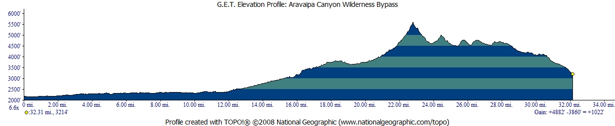
| ELEVATION
PROFILE |  |
ALTERNATE ROUTE:
ARAVAIPA CANYON WILDERNESS BYPASS Hikers
who find it necessary to bypass Aravaipa Canyon Wilderness - for instance, to
avoid dealing with the permit system, or when permits happen to be unavailable
or you're off-schedule - can instead follow this bypass route. But please note:
Because Aravaipa Canyon cuts deeply into a rugged mountain range - the Galiuros
- which otherwise presents a barrier to east-west progress, few roads or trails
cross the range nearby. So this detour - also like the "North Detour"
described in Chapter 7 - is fairly out-of-the-way, and is therefore lengthier
than the main route by about 12 miles. This detour is mostly on primitive roads,
generally little-travelled graded dirt or rough 4WD tracks, and is by and large
a scenic and attractive alternative, even if it lacks the erstwhile charm of Aravaipa
Canyon. The route also passes through the town of Mammoth along the way, so is
fairly convenient for hikers already planning a layover there. This
alternate route bypasses all of the main route in Segment 6, as well as the first
10 miles of Segment 7 in Aravaipa Canyon. It begins on the west near AZ Highway
77 and ends near the east entrance of Aravaipa Canyon Wilderness at Turkey Creek. From
the offset 4-way road junction at mile 13.8 in Segment 5, (waypoint 05155) eastbound
hikers follow the southbound dirt road, paralleling the railroad grade. This road
continues all the way to the outskirts of Mammoth, generally near the old railroad
and outside the San Pedro River's riparian zone. Approaching the outskirts of
Mammoth, the graded dirt road reaches a t-junction
by a cattle guard; turn left here (east) onto paved Camino Rio, then right onto
AZ 77 at 8.1 (waypoint 06300). (One could also hitchhike down AZ 77 from
the main GET crossing into Mammoth, but would not be advised to hike along this
winding 2-lane highway.) Follow
AZ 77 into town. The Lodge motel is on the right, with Tortillas Mi Pueblito (Mexican
restaurant) just next door. Here, at 8.6, our detour turns left at the
fork onto Main Street. Pass Main Market and then the laundromat (both
out of business as of 2012) on the left. At 9.5 (elev. 2300') turn
left (east) onto Copper Creek Rd, crossing the wide wash of the San Pedro River
at the edge of town. (Be sure to pick up water before proceeding.) Stealth camping
may be possible in the mequite thickets beyond the wash. At 10.3, turn
left (north) onto paved River Road. Continue to signed 2WD unpaved Cowboy Miller
Rd at 11.6 and turn right, east. Cowboy
Miller Rd proceeds 8.1 straightforward miles into the foothills of the Galiuros.
It becomes a 4WD track as it approaches Dry Camp Canyon. Keep right at 19.7,
(waypoint 06340) bypassing the road to Dry Camp itself, as shown on maps. Where
the track crosses the canyon's wash at 20.1 (waypoint 06350), leave it
and head east up the wash itself. In less than 0.1 mile, a lesser drainage enters
from the left. Take this drainage. Despite a few scrambles over the bedrock
bottom, you may well find some pools of water, including an improved spring
in a shady setting at 21.3 (waypoint 06360). Secluded camping is possible
in the vicinity. Three
ATV tracks converge upon the spring. Take the right-most track, immediately leaving
the drainage on its south bank. The 2-track climbs sharply among the final saguaro-cloaked
hillsides of an eastbound hiker's journey, ending at a t-junction with a wider,
rockier 4WD road at 22.1 (06370). This is informally known as the Rug Road,
and is a cult favorite of off-highway vehicle enthusiasts, due to its rough, steep,
and scenic qualities. The Rug Road takes it name from pieces of carpet that motorists
have used to fill washed out sections of the road. Yep - it's that rough. Outside
of weekends, though, the Rug Road is fairly quiet, and the high-desert scenery
it traverses is outstanding. You'll follow it the rest of the way to Turkey Creek
at the east end of the detour. Turn
left (north), climbing to reach a saddle at 23.0 (elev. 5400'). The Rug
Road becomes a roller-coaster ride as it now descends and climbs steeply through
several prominent canyons that drain north into Aravaipa Canyon. You'll wonder
how any vehicle could manage this road, with its perpetual fare of loose, softball-and-basketball-size
volcanic rocks, wash-outs, and long, steep grades. The Rug Road crosses lateral
tracks in Virgus and Parsons canyons, and in Parsons,
possible water in the creekbed near a former homestead - a good shady camping
spot. Views eastward
open dramatically after passing an old corral at 29.2, with the rugged
Santa Teresa Mountains prominent on the horizon. Now begin a long descent into
Turkey Creek, as the road bravely cuts through a "slickrock" sedimentary
layer in the company of colorful cliffs. Breathe a hearty sigh of relief as the
road finally bottoms out in the riparian zone of Turkey Creek at 32.2 (waypoint
07510, elev. 3300'). (Westbounders looks carefully for the Rug Road as it switchbacks
away through a cliff cut on the west bank of Turkey Creek.) The creek is normally
dry here. Eastbounders
now have two options for travel. One is to turn left and walk north down Turkey
Creek to its confluence with perennial Aravaipa Creek
and a resumption of the main route in 2.6 miles. This point is at mile 10.8 of
Segment 7, just east of the Aravaipa Canyon Wilderness boundary. . The
other travel option from the Rug Road is to turn right in Turkey Creek, heading
south. Walking south up Turkey Creek and beyond via the Turkey Creek alternate,
described in Segment 8, leads to the community of Klondyke in 10 miles. This alternate
can be a good option for hikers planning to resupply or layover in the Klondyke
area. Turkey Creek sometimes has water up-canyon. See Segment 8 for more information. 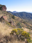
|