G.E.T.
Guidebook
Segment 27: Monticello Box 29.5
miles  Guidebook
Home Guidebook
Home
Open
this page for printing
Submit
feedback for this segment
|
Segment
Length | Segment
Status | Season |
|
|
|
29.5
mi. | unfinalized
but accessible | spring,
summer, fall | | Resources |
| OVERVIEW
MAP | 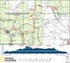 |
| ELEVATION
PROFILE | 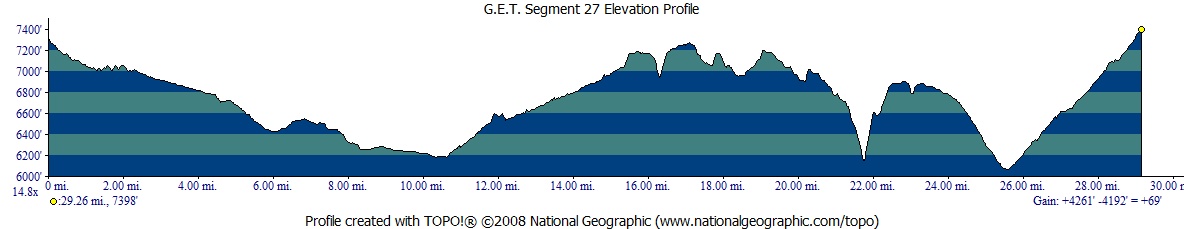 |
G.E.T. Topo Maps 70-74
Town Guide: Winston | Monticello
Water Chart
Image Gallery: Album 7 |
Additional maps:
Cibola National Forest:
Magdalena Ranger DIstrict (USFS)
Land management
agencies:
Cibola
NF Magdalena Ranger Distric
|
| Beginning
access point | | Ending
access point | |
FR 913 at Trail 60. 5
miles north of Truth or Consequences NM take exit 83 off Interstate 25 onto paved
NM 181 North, then turn left onto paved NM 52 (west). In ~31 mi. from I-25, reach
community of Winston (last gas station.
In ~10 more mi. pass junction with NM 59, remaining on NM 52 which becomes a graded
dirt road. In ~4 mi. turn left (west) onto lesser dirt road signed for National
Forest access. High-clearance 4WD recommended beyond this point. In ~2 more miles
turn right at a junction, following road out of Silver Creek wash up to mesa,
reaching Gila NF boundary in ~3 miles. Trailhead access is approx. 5 road miles
beyond this point in Duck Canyon, south of waypoint 27010 as indicated on topo
mapset. To navigate confusing road network, GPS (esp. with satellite imagery)
recommended. Contact USFS for current road conditions and status of private inholdings
en route. (Please note: No vehicle access to trailhead from Dusty area due to
locked gates.) | |
Trail 50 Trailhead near
FR 377. 5 miles
north of Truth or Consequences NM take exit 83 off Interstate 25 onto paved NM
181 North, then turn left onto paved NM 52 (west). Continue 2 mi. then turn right
onto paved NM 142 and continue 14 mi. to Monticello
(no vehicle services here nor in Placitas en route). Turn right (east) on signed,
graded dirt FR 139. (Do not continue straight on dirt NM 142
in Monticello Canyon, which offers no legal vehicle access to the trailhead.)
In 3.5 mi. turn left (north) onto signed FR 377 aka the Burma Road. This steep,
primitive road requires high clearance, or 4WD when wet or following floods. In
11 more mi. reach t-junction (waypoint 27320) with unsigned 2-track road on right
to Shipman Trail 50 trailhead in a half mile. | SEGMENT
OVERVIEW Monticello
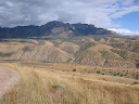
Box Canyon is truly one of southwest New Mexico's hidden gems. Flanked by colorful
rock formations and rugged cliffs, a narrow ribbon of verdant splendor unfolds
through the heart of an arid grassland. Sustained by the year-round flow of Alamosa
Creek, this extensive riparian corridor is home to the familiar Fremont cottonwood,
the common assemblages of willows and ashes found elsewhere along the trail; the
chortle of songbirds fills the air on spring and summer mornings, while birds
of prey watch cautiously from leafy roosts, or soar indolently, high overhead.
Yet despite such obvious similarities with other desert-bounded creeks, much about
Monticello Canyon feels unique as well; this place would not be mistaken for Aravaipa
Canyon, the Blue River, or Eagle Creek. At an elevation of 6000 feet, Monticello
Canyon is a high valley, notably higher than its counterparts to the west. The
surrounding landscape is distinctly New Mexican: austere, the scene contemplative,
the terrain self-evident yet somehow unknowable, full of mystery. And a riparian
community of this nature and extent, set against this high desert backdrop, is
a rare thing indeed. Here, javelina roam at the very limit of their geographic
range. Sizable herds of mule deer are often seen (while the smaller coeus variety
of Arizona is not). And nowhere along those distant canyons to the west are Rocky
Mountain elk as at home - if home at all - as here. The
canyon's creek is born from a cluster of springs that surface just above the canyon.
These perennial waters, including the beautiful Ojo Caliente - "warm spring"
- made the area a favorite of the ancestral Apaches, including Chief Victorio
and even the legendary Geronimo. During the Apache wars of the 1870's the area
tribes were moved here by the US Army. Yet with white settlers increasingly drawn
to the region, the Warm Spring reservation never flourished, and the tribes were
eventually relocated to the larger San Carlos reservation in Arizona. Today the
only evidence of the old Warm Spring reservation, once occupied by some 3000 souls,
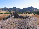
are the remnants of a few adobe walls, crumbling and nearly forgotten. This
segment of the Grand Enchantment Trail also serves as a linkage between the vast
Gila National Forest to the west and the scattered, island-like districts of the
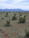
Cibola National Forest to the east. The route first descends out across rolling
foothills at the edge of the Black Range, where pronghorn are often spotted along
grassy hillsides dotted with soaptree yucca. Easy cruising along lonely dirt roads
interspersed with brief sections of cross-country travel keeps navigation relatively
straightforward. The route enters the old reservation boundary and crosses NM
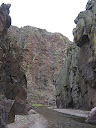
Highway 52 within sight of Monticello Box, the dramatic, and seemingly improbable,
cliff-bound entrance to the water-blessed canyon beyond. Hikers with a maildrop
waiting in Winston can try their luck hitchhiking via the sparsely-travelled dirt
byway, while those who've sent supplies to Monticello continue along the GET nearly
through segment's end, then press on another 14.8 miles to town (via the Monticello
Spur out-and-back alternate route). (See the Town
Guide for more about the pros and cons of resupplying in either town, and
why it's a good idea for thru-hikers not to forego a maildrop altogether.) The
GET in Segment 27 once traveled far down Monticello Canyon, but the visiting public
(including recreationists of all stripes) lost access in 2015 after a protracted
and bitter dispute involving a couple of landowners (and the Socorro and Sierra
county government officials who ultimately sided with them). As a result our foray
along Alamosa Creek itself is now fairly brief, but with a very worthwhile (some
would say mandatory) side-hike option to visit Monticello Box and the most impressive
terrain here. Walking in the creekbed is generally an easy, gentle slosh, no more
than calf deep. Flood events can occur following heavy summer storms, when hikers
would be well advised to keep a backup plan, but the high water tends to subside
fairly quickly. The
latter part of this segment is dedicated to finding a way around the off-limits
portion of Monticello Canyon. Admittedly it's a convoluted and adventurous route
involving dirt roads, dry washes, and cross-country travel up and down grassy
foothills of the San Mateo Mountains, but it's also a very beautiful and rewarding
walk in its own right. Having the proper mindset is a helpful prerequisite here
- don't expect fast and easy miles, and know that this is nonetheless the most
efficient route we've found that preserves the integrity of the journey across
this outstanding corner of New Mexico.
ROUTE
DETAILS MP
0.0 This segment begins at a saddle along unsigned Trail 60 a short distance
inside the Gila National Forest (waypoint 27010). Here the route (eastbound) leaves
the trail, jogs east a few yards to a north-south fenceline, then heads north
along the west side of the fenceline swath (not Trail 60). (However, thirsty
hikers should first consider seeking out an off-route water source with favorable
historical reliability
located about a half mile to the south. To get there, follow Trail 60 south, with
occasional cairns, as it runs near the fenceline and becomes more of an old road
or swath before ending by an ad hoc parking area along a feeder road of FR 913.
Follow this road left to its junction with the main road. Turn left again, then
soon after crossing a minor drainage turn right onto a lesser track to reach a
solar-powered well with metal tank at the
Gila National Forest boundary [waypoint 27020]. No camping allowed within the
fenced area here, which is private, as is all of land section 36 to the east,
just outside the forest. Also note an earthen impoundment, on public land just
west of the well enclosure, less reliable and used by cattle.) MP
0.3 The track, occasionally vague or divergent, reaches a self-evident gate
in the fence by an old wooden post (waypoint 27030). (Note - this fence was reportedly
restrung in 2017 and no longer features a gate.) Head east through the gate to
find a still-more-primitive swath beyond. This swath is followable with care to
a point just west of the pond indicated on the mapset (waypoint 27040), else just
join the drainage and follow it east to the wildlife
pond, which was full and clear with both inflow and outflow (and no
cows) on first observation (Fall 2014 relo). The Gila National Forest boundary
en route to the pond is not signed or otherwise demarcated but at the pond - Section
25 - we're in BLM land. Immediately south - Section 26 - is private land, which
should be avoided. To do so, please follow in the drainage east of the pond or
on the north bank and do not follow any roads you may encounter en route. (From
here to Alamosa Creek environs the GET route represents a 2014 relocation in order
to avoid straying onto a patchwork of uninhabited but privately owned range land
sections east of the Gila NF boundary.) MP
1.3 Beyond the wildlife pond, our next destination is a 2-track road on BLM
land. First you'll cross an improved "ranch road" - ignore this one.
Then, just before reaching our 2-track you'll encounter another north-south fence.
Seek out a gate a few yards north of the drainage (waypoint 27045). A secluded,
partially-forested camp could also be made in the vicinity, one of the last sheltered
areas for quite some distance heading east along the route. Now
join this primitive track (waypoint 27050), turning left (northeast). The track
crosses several more east-draining washes (shortcutting not advised due to ungated
fences and topography) ... MP
2.0 ... then ends at a "multi-way junction" (waypoint 27060). Pass
east through a likely open metal gate here and immediately turn southeast, ignoring
a road that continues due east. A small trough with float
valve is located in the fenceline 20 yards south of the gate. Keep
left at a junction (waypoint 27070) - if evident at all. Our road, again a primitive
2-track now, keeps to the height of land along a scenic grassy mesa - extraordinarily
open country - for the next several miles. MP
3.2 Take the right fork at waypoint 27080 (again, if evident, as our road
may often be the only one visible on the ground) to reach a pair
of float-valve troughs.. MP
4.4 Continuing east along the main mesa-top track, find a corral and tire
trough. The 2-track next reaches a metal gate (waypoint 27115) then
begins a more earnest descent as it remains along the narrowing ridge crest, eventually
passing above an unreliable earthen stock pond. MP
5.8 Reach a junction with a somewhat better road at 5.8 (waypoint 27130).
Turn right (south) onto this road, then right again (southwest) onto another ranch
road (waypoint 27140) . MP
6.4 Note a corral just off to the south near Duck Canyon's drainage, containing
an enormous tire trough with float-valve (waypoint
27150). The tire clearly must have come from a mining ore truck (of the sort used
at the Morenci mine in Arizona and elsewhere). From
6.4 the suggested route of the GET heads out the back of the corral through a
gate, then runs south, uphill, along the west side of a fenceline. The fence reaches
a corner (with the yellow dashed fenceline shown on the mapset). Turn right (southwest)
here briefly to find another gate (waypoint 27160). Pass through this gate then
head southeast briefly to reach an east-west 2-track road along the crest of the
broad, grassy ridge. Head east on this road - scenic and all-but-unused by vehicles
(a familiar refrain in these lonely parts). IGNORE a track that splits off to
the left, downhill at waypoint 27170 (if evident) ... MP
7.9 ... THEN TAKE the left fork at a nearly identical sort of junction (waypoint
27180) - this one obvious. Follow the track downhill to the northeast, where it
becomes vague approaching a north-south fenceline. There's no gate in this fence,
and only a trace of the track may be evident continuing on the opposite side,
but nevertheless crawl under the fence at an opportune spot then head southeast.
Avoid heading down the shallow drainage here (lined with old tires). Beyond, the
track reappears soon before a final descent to the flood plain of Alamosa Creek.
Here find a corral (waypoint 27200) with a small, pipe-fed
pond and metal trough with float valve.
The 2-track now heads northeast, first through a metal gate, then across the dry
wash of Alamosa Creek (which normally begins to flow just above Monticello Box). MP
8.9 The 2-track ends at
a junction with graded dirt NM Rte 52 (waypoint 27210). (A wire gate across the
unsigned 2-track at NM 52 was unposted at last check, thus the 2-track should
be a legal travel corridor unless circumstances happen to change.) From this point,
the community of Winston is about 22 miles south via NM 52. (The place name of
Dusty, 4 miles north, offers no services.) MP
9.4 After co-opting NM 52 southbound for a half mile, the GET turns left (east)
at a signed junction with County Road E-14. A private, posted road heads north
at waypoint 27230, while our route continues southeast toward Monticello Canyon
on a public right-of-way (technically CR 142). MP
10.1 The public right-of-way continues across a well-posted (and locked) metal
gate along the roadway (waypoint 27235). This gate was installed in 2015 during
the Monticello Canyon access dispute. However, the public - it was legally determined
- has a right to continue beyond this gate as far as state land section 32 (as
shown on the topo mapset), including through the most spectacular portion of Monticello
Box. And this allowance is being honored by the Monticello Community Ditch Association
which owns the surrounding land here. Vehicles need the combination to the gate's
lock in order to proceed (available from the NM state land office via permit),
while pedestrians are inclined to simply climb over. Beyond the gate you may continue
to note occasional signs indicating private property. Please do not camp until
rejoining USFS land at milepoint 12.0. MP
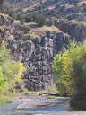
10.8 The increasingly primitive dirt road reaches a (likely) signed trailhead
of sorts on the left. We'll take this trail, but first, by all means continue
ahead in the canyon bottom toward the dramatic entrance to Monticello Box. Here
and beyond, the road shares the canyon floor with Alamosa
Creek. This perennial creek, here still in its infancy, is formed in
part by Ojo Caliente just upstream, the waters of which comingle with other springs
and surfacing flow within the main drainage. Head on down alongside the sheer,
highly metamorphosed volcanic cliffs of The Box, marveling at the improbability
of this geologic spectacle. You can explore for around a mile or so along the
meandering creek, sloshing back and forth as dictated by the terrain, before the
road is blocked where state land reaches private ranch land. Turn around here
- DO NOT continue down the canyon beyond this point. MP
10.8 From the trailhead, head north on a primitive foot trail leading a few
tenths of a mile up an intriguing side canyon off Alamosa Creek, which is animated
year-round by the lively dash of tepid water cascading from Ojo
Caliente. The warm spring itself, which is a mild 85-90F or so, has
been improved to form a small wading pool. Please do not camp here or elsewhere
until reaching USFS land ahead. Beyond the spring, continue up the drainage, now
cross-country in the wash. Seek out a gate just left of the wash (waypoint 27250)
where a fence crosses it, then return to the wash. MP
12.0 Enter USFS land at another fence. You can either negotiate the fence
near the drainage or head steeply uphill to the left (west) to cross the fence
at a gate (waypoint 27260). A trough is located
near the gate, with another trough in a saddle
along the ridge not far inside the forest boundary. MP
12.4 Join the drainage of Wild Bull Canyon via cow path (or any convenient
means) from the ridgeline saddle trough. Head cross-country (northeast) up the
modestly-sized wash for a couple of miles, with several camping opportunities
en route, adjacent the drainage.. MP
14.5 Junction of
nearly equal-caliber drainages (waypoint 27280). Take the right fork (northeast).
The wash narrows a bit and becomes brushy at times as you continue. A 2-track
road enters the wash from the north (waypoint 27282) - follow the road and wash
east. MP 15.5
The 2-track climbs out of the drainage, first passing a junction to Boulder
Tank (seasonal earthen impoundment, often of fair quality) and then
reaching a 2-track junction. Take the road running east, which follows a ridge,
soon bending south. The road meanders and loses an unnecessary amount of elevation
for our purposes, thus the mapset shows a cross-country shortcut, striking off
easterly and dropping to cross Bar A Canyon before rejoining the road along another
ridge, here following the road north. This road too eventually bends around, where
it starts to parallel a fenceline south. Another 2-track road runs along the opposite
side of the fence. Cross the fence here (over or under) and continue east, cross-country,
down into the drainage of Bobtail Canyon. Follow the wash south. MP
17.7 Bobtail Tank is located east in a
side drainage of Bobtail Canyon (waypoint 27286). The earthen tank is often murky
and sometimes has cows, but seems to be fairly reliable in this otherwise rather
dry stretch. This may well be your last water heading east to segment's end (and
for the first mile or so of Segment 29), a distance of perhaps 13 miles, so by
all means consider tanking up. (Distance to next water could be even greater if
following the Monticello Spur resupply route into Monticello village.) The route
continues south in the main Bobtail Canyon. Just after a junction with a lesser
wash on your left (east), look for a prominent cow path leaving Bobtail Canyon,
also on your left. The path climbs up and over a ridge, dips across a shallow
drainage, then works its way down (or alongside) another drainage east to Elk
Tank. MP 18.7
Elk Tank is usually dry (waypoint 27288). Head east of the tank to find a 2-track
road and follow it east. The road soon bends south, climbing. Where it next turns
west or southwest, leave it and resume cross-country travel (waypoint 27290).
The prominent canyon to your east is Kelly Canyon, and our goal is to cross it
in a more favorable location than here (the going is VERY rough in this vicinity,
so continue with the route as shown on the mapset). As you head south along the
ridge crest, be sure to keep as far east as possible to avoid getting off onto
other ridges. You want to keep Kelly Canyon close by the entire way. Ridgetop
walking here is mostly in a grassland environment. MP
21.5 Use GPS as necessary to find the recommended mapped location to leave
the ridge crest (waypoint 27292). Here proceed southeast down a relatively low-angle
buttressing ridge into Kelly Canyon. MP
21.9 Cross the drainage of Kelly Canyon (usually dry despite prominence on
map) and head nearly due east up the other side. This side is steeper, so take
your time and find the best route possible. Cross a 2-track road and shallow drainage
(waypoint 27294), then resume a cross-country ascent up to a broad mesa. Join
another road here briefly, following it northeast, then leave it again (waypoint
27296) on an x-c jaunt southeasterly across yet another drainage. Reach FR 76,
a north-south-running road on the mesa beyond. A short connector road heads east
to FR 377 aka the Burma Road. (Be sure not to take FR 76 by mistake.) Whew! Your
wild, meandering workaround of Monticello Canyon and its private inholdings is
nearly complete! MP
23.5 Joining the Burma Road / FR 377, proceed due south. The road eventually
switchbacks to begin a descent into the wide wash of San Mateo Canyon. (The
Burma Road, which for many miles follows a torturous course along the western
foothills of the San Mateo Mountains, is very scenic, rugged, and sparsely travelled.
The colorful name for this Forest Service road is borrowed from the original Burma
Road that was constructed between the nations of China and Burma around the time
of the 2nd World War, and which was notoriously winding and mountainous.) MP
25.9 Pass a junction with FR 9049 in San Mateo Canyon (camping prospects this
area), and continue on the Burma Road as it climbs out on a switchbacking traverse.
Regaining a broad ridge, the road ascends gradually eastward MP
28.8 Arrive at an unsigned junction where the Burma Road levels out by a cattle
guard (waypoint 27320). Here the Monticello Spur alternate route continues south
via the Burma Road (for resupplying in the village of Monticello), while the main
GET turns left (east-northeast) onto a lesser 4WD track, technically the start
of Shipman Trail 50. MP
29.5 The track arrives at a turnout by a gated fence (waypoint 28010, elev.
7400') - the unassuming trailhead for Trail 50, which becomes singletrack trail
as it approaches the Apache Kid Wilderness in Segment 29.
ELEVATION
PROFILE:
MONTICELLO SPUR | 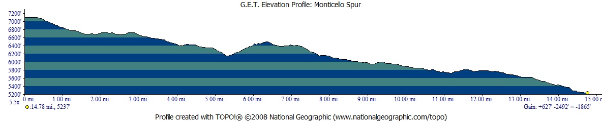 |
Monticello Spur
Altenate Route This
Alternate Route is the recommended way to resupply via the Monticello post office.
Hikers would then return to the main GET by repeating the same route in reverse
(refer to the topo map set), such that budgeting extra food may be required both
to reach Monticello and then in a maildrop sent here for use on the way out. A
dirt roadwalk in its entirety, this alternate route nonetheless features very
little vehicle traffic overall, and you should at least plan on having to walk
the whole way. It's a scenic route, wending its way across the foothills of the
San Mateos. With the exception of the last five miles into Monticello, the route
is located on public land, with plenty of camping opportunities but potentially
little water. MP
0.0 From the junction of the main GET at MP 28.8 (waypoint 27320), continue
southeast on the Burma Road. MP
1.8 The road crosses Shipman Canyon (usually dry). Shipman Spring (and cabin),
north in the drainage, were not visited and this source is of unknown reliability MP
5.3 Road crosses Garcia Falls Canyon, with seasonal Garcia
Falls up the drainage a short distance. Take the right drainage fork.
If the main falls area is dry, you can climb up a short metal ladder bolted into
the cliff to scout the scenic little drainage above. A worthwhile side trip either
way. You might find the occasional vehicle user here on weekends, such that traffic
as you continue along the road might be slightly more favorable for hitchhiking
purposes. MP
9.8 The Burma Road leaves public land (Cibola National Forest) around here,
or look for signs indicating where private property (Red Rock Ranch) is encountered.
MP 11.0
Turn right (southwest) on FR 139 (waypoint 27370). Although vehicle use remains
very light, anyone heading your way [particularly locals] may be willing to offer
a ride the rest of the way into town. (Probably don't stand around waiting, though.) MP
14.5 Turn left (southeast) on NM 142 into Monticello village. Pass the Darlen
Casitas on your left, then the historic town plaza on the right. MP
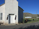
14.8 Monticello Post Office is on the left. See the Town Guide for current
hours of operation, as well as full details on Monticello village. Keep in mind
that no public land occurs in the immediate vicinity of town. If camping isn't
available at the town plaza, you might consider continuing south on NM 142 another
1.5 miles or so beyond the post office; the northern three-quarters of mapped
Section 2 (north and east of Placitas) is state land. Otherwise, backtrack 5 miles
along the route to the Cibola National Forest boundary.
 Segment 28
| |