G.E.T.
Guidebook
Segment 24: Black Range Crest 16.5
miles  Guidebook
Home Guidebook
Home
Open
this page for printing
Submit
feedback for this segment
|
Segment
Length | Segment
Status | Season |
|
|
|
16.5
mi. | finalized
& accessible | spring,
summer, fall | | Resources |
| OVERVIEW
MAP | 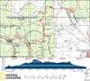 |
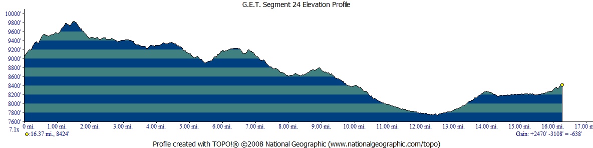
| ELEVATION
PROFILE | 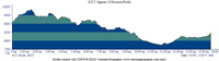 |
G.E.T. Topo Maps 64-65
Town Guide: Chloride / Winston
Water Chart
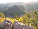
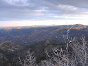
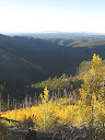
Image Gallery: Album 7 |
Additional maps:
Gila National Forest (USFS)
Land management
agencies:
Gila
NF Black Range Ranger District
|
| Beginning
access point | | Ending
access point | |
Trail 69 at CDT (Trail
74). This segment
begins within the Aldo Leopold Wilderness atop the Black Range Crest (Continental
Divide), at a remote location accessible only on foot or horseback. For the nearest
vehicle access to the west, see the Beginning Access Point for Segment 23. | |
FR 226A at CDT (Trail
74). 5
miles north of Truth or Consequences NM take exit 83 off Interstate 25 onto paved
NM 181 North, then turn left onto paved NM 52 (west). In ~31 mi. from I-25,
reach community of Winston (last
gas station). Continue ~10 more mi. and turn left onto paved NM 59. Follow ~13
miles to signed crossing of Continental Divide. Continue ~1.6 mi. and turn left
(south) onto dirt FR 226, then left onto FR 226A (both high-clearance & 4WD
advisable) toward Lookout Mountain. ~11 miles from NM 59 reach signed CDT crossing.
Park along shoulder.
Alternate ending access point: Continue on FR 226 (not 226A) approx 10
more miles, (4WD advisable) along the way passing signed CDT trailhead on left
(northbound), to next trailhead on right (Caledonia Trail 42). Or reach this trailhead
from Winston by following paved road 3 miles to Chloride, then dirt FR 226 for
12 miles (steep, rough mountain grades: 4WD high clearance required). |
PLEASE NOTE:
THIS CHAPTER REMAINS UNFINISHED. SEGMENT OVERVIEW AND ROUTE DETAILS INFO BELOW
ARE IN DRAFT FORM AND HIGHLIGHT ONLY THE ESSENTIALS NEEDED FOR NAVIGATING THIS
SEGMENT IN CONJUNCTION WITH THE TOPO MAP SET. SEGMENT
OVERVIEW This
is the first of three segments to utilize the official route of the Continental
Divide Trail along the Black Range Crest, a region seldom seen by long-distance
CDT hikers as many follow the "Gila River route" due to its perceived
water advantages. Yet while water is certainly less abundant along or near the
Continental Divide in this stretch, it is more available than conventional wisdom
would have one believe. And while the terrain is indeed challenging in some respects
- some of the old burn areas continue to feature occasional blowdowns, vague trail,
and poor signing - there are other areas here and in the next two segments that
are in good shape, with smooth, contouring tread offering many miles of fine walking.
Much of the terrain
here is located within the Aldo Leopold Wilderness - a fitting tribute, so named,
to the preeminent conservationist who fought to preserve this region as part of
the first Congressionally-designated Wilderness. Solitude remains a frequent companion
throughout. This
segment starts near 9800-foot Diamond Peak and for the first 10 miles tours the
prominent crest of the Black Range, so called for its historically deep and darkly
forested network of ridges and canyons, complex and sprawling in their reach above
the surrounding desert. Multiple lightning fires, particularly in the 1990's,
have burned many square miles of the Black Range, lending their appellation a
certain irony now. The fires affected much, though by no means all, of the initial
10 miles of this segment. Thanks to ongoing trail maintenance efforts by the Forest
Service and CDT-related partnerships, the trail itself, for a majority of this
segment's length, has been rehabilited or otherwise is not heavily impacted, save
for the occasional sun-bleached and fire-hardended tree trunk that continues to
topple during a windstorm. Still, and not surprisingly, New Mexico locust and
other sun-loving briars make their trailside presence known here and there, but
so do the young, pioneering aspens, now setting whole mountainsides ablaze once
more with their autumn color, reminding us of nature's cycle of renewal. (Abundant
wild raspberries have become another autumnal highlight.) And the views, in the
absence of uninterrupted stands of timber, now extend unobstructed for miles untold. Water
is sometimes available at Diamond Peak Spring, though this source is small, fragile,
and often difficult to collect from. Better prospects (in addition to the small
creek in nearby Burnt Canyon in Segment 23) are to be found a few miles to the
north, as well as in the vicinity of Chloride Creek toward segment's end, with
excellent camping available in the sheltering canyon forest here. Lightning
has always been a concern for travelers along the Black Range Crest, now more
than ever due to the added exposure here. Monsoon-style storms occur regularly
during afternoons in July and August, though hikers would be well advised to keep
an eye to the skies any time weather may be building. (Several side trails leading
off the crest are available if needed). Hikers in springtime more often may encounter
snow, in the form of remnant snowpack, though this is typically of minimal depth
and coverage by the time thru-hikers arrive in mid or late April - often limited
to the area between Diamond Peak and Fisherman's Bluff.
ROUTE
DETAILS Good
trail (CDT / Trail 74) leads up along the main ridge south of Diamond Peak, but
becomes rougher as ridge turns more northeasterly, entering some burned terrain.
Summit of 9800 foot peak itself spared the burn; camping possible alongside trail
among spruce/fir in the vicinity; former summit fire tower site just off trail,
with commanding views east including Rio Grande Valley, San Mateo Mountains (Seg
28-29), and distant Tularosa Mountains. Trail
74 descends to 2014-built switchback just above signed junction at 1.8.
Here our Trail 74 continues downhill, while Trail 61 heads north. South at junction
leads short distance (via former trail route, tread still somewhat visible) to
Diamond
Peak Spring. Spring
is often just a wet spot in the eroding hillside and may require effort to fill
a water bottle without filtering it up; be careful not to damage this fragile
source. Layout of switchbacks not definitive; several intersecting options available,
continue downhill to northeast. After some potential blowdowns, the CDT becomes
better defined again as it turns north at waypoint 24050. The tread is generally
good, with just occasional blowdowns and some thorny growth in places, otherwise
mostly wide and clear of debris. In general, layout of trail is excellent throughout
this area - easy going contours, with great views. Where
trail crosses small wooden bridge over minor drainage near 5.2,
listen for a little rill among the rocks,
sometimes visible or else head up drainage short distance for best prospects.
This drainage is surprisingly reliable, albeit often quite marginal to collect
from. (In an emergency, Fisherman's Canyon / Diamond
Creek typically hold water, a bit over a mile steeply down off the
Divide.) CDT slabs
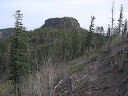
along west side of prominent Fisherman's Bluff, then ascends to flat moonscape-like
expanse just north of bluff around 6.4. Previously a wreck, 2010 maintenance
now renders this section of trail easy to follow through the burn and beyond.
Nevertheless will maintain previous wording for the remainder of this paragraph
to assist in the event that the trail becomes vague again... "The trail mostly
follows a downed fenceline all the way to point 9204 per the map, though the fenceline
isn't always evident. In any case, head east-northeast at first, then as standing
dead timber lessens and terrain becomes more open, look for makeshift cairns and
some vague tread. Easterly jog at 6.4 (waypoint 24080) easy to miss - heads through
tunnel of young aspen here - then becomes more evident as it turns north and drops
to saddle on ridge. A broken-down barbed wire fenceline is often visible just
east of the trail where near the word "Divide" on the map. (Westbounders,
climb south from the saddle south of point 9204 on map. Leveling out, keep old
wire fenceline - if evident - on left. Jog west to follow vague trail through
young aspen tunnel, then turn south again back in the open. Look for cairns and
some vague tread. Easy to lose again as standing dead timber thickens at southwest
edge of mesa just north of Fisherman's Bluff, but poke around here for more obvious
trail which soon slabs south along western slope below bluff.)" Exit
the Aldo Leopold Wilderness at 8.1, demarcated by an old metal Wilderness
sign on a tree. At 8.7 the mostly sidehill-contouring trail runs briefly
through an unburned forested flat with some of the best camping prospects in a
while just off trail to the northeast. Wild raspberries are often abundant from
here to around 10.8 during autumn. CDT Trail 74 joins Caledonia Trail 42 at signed
junction at 9.5. Eastbounders turn sharp right (westbounders
turn left - watch for signboard on tree to your left and don't continue straight
on Trail 42). Approaching
waypoint 24120 the CDT descends an exposed slope via well-graded switchbacks on
reestablished / relocated tread, leaving physical Divide here. (Circa 2009 trail
maintenance begins anew here, and continues northward through the end of this
segment and beyond, all the way to Wahoo Peak area in Segment 26.) The trail then
turns north alongside a prominent drainage,
by and by leaving the burned terrain behind. (Westbounders, the CDT turns
sharp right at waypoint 24120, climbing out of the drainage via switchbacks. Don't
continue straight on unsigned/overgrown continuation of trail in drainage.)
You may well find flowing water in the vicinity of an old homestead along the
trail at 11.4 - only a stone chimney remains now. Both water and camping
prospects continue to improve heading down the well-forested, flat-floored canyon;
plan to tank up here, rather than in the canyon of Chloride
Creek just ahead, which is somewhat less reliable. (The two canyons
merge not far below the trail.) The
CDT reaches dirt 4WD FR 226 at signed trailhead for Caledonia Trail at 13.0.
Here the route of the CDT turns left (west) along the road. (Heading the other
way along FR 226 would lead to the near ghost towns of Chloride in 12 miles, and
Winston in 15. The rough road descends 2000 vertical feet en route to Chloride
and receives virtually no vehicle use save for the odd weekend OHV. Chloride Creek
is nearby at times, and seems to be perennial in places. Please note: Monument
Park Cabin, shown on the topo map, administered by the USFS, is generally locked
and unavailable without prior arrangements.) Cresting
the physical Divide once more, FR 226 drops west a bit then reaches a signed CDT
trailhead on the right (north) at 14.7, from which singletrack
trail diverges, albeit often vaguely at first. (To visit Turkey
Spring - a cement tank and pair of troughs in a corral - continue west
via FR 226 or directly down Seventy-Four Draw for 0.75 mile.) The trail soon contours
along a forested slope above Seventyfour Draw, then descends into this drainage
at 15.7 (waypoint 24170). Just before it does so, ignore a game path that
climbs away at right (east) at an unmarked junction (waypoint 24165). Continue
on singletrack up the pretty, park-like floor of the drainage, with ample dry
camping opportunities. (Westbounders, the CDT leaves Seventyfour Draw on the
left at 15.7. Now remain on the contouring trail along the southeast side of Seventy
Four Draw and ignore an unsigned "game path" that forks left, climbing.)
The CDT then slabs uphill on a closed forest road to reach FR 226A at segment's
end, 16.5. |