G.E.T.
Guidebook
Segment 10: Pinaleño Mountains 25.9
miles  Guidebook
Home Guidebook
Home
Open
this page for printing
Submit
feedback for this segment
|
Segment
Length | Segment
Status | Season |
|
|
|
25.9
mi. | finalized
& accessible | spring,
summer, fall | | Resources |
| OVERVIEW
MAP | 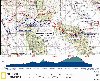 |
| ELEVATION
PROFILE | 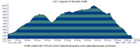 |
G.E.T. Topo Maps 30-32
Water Chart
Image Gallery: Album 3
| Additional
maps:
Coronado
N.F. Safford & Santa Catalina Ranger Districts (USFS)
Land management agency:
Coronado
National Forest Safford Ranger District |
| Beginning
access point | | Ending
access point | |
FR 286 at FR 675.
From Safford, take US 70 west to Pima and turn left at sign for Tripp Canyon Road
/ FR 286. Reach an intersection with Patterson Mesa Rd within a half mile and
turn left. FR 286 resumes at right within a quarter mile, marked by metal signs
(brief easement through private land). A large swinging gate soon encountered
should be left as it was found. Proceed southwest on dirt 2WD FR 286. In ~15 miles
from Pima reach a junction with 4WD FR 351. Keep straight on FR 286, heading up
Tripp Canyon. A dirt lot and car camping area is on the right at ~19 mi. from
Pima, at a signed junction with FR 675. (A 4WD vehicle could also get here
via Klondyke Rd by following the directions for the "beginning access point"
for Segment 9, but turning off at FR 351, taking this 4WD road to the junction
with FR 286, and continuing as described above.) | |
FR 307 at Ash Creek Trailhead.
From Safford, follow US 70 west to Pima, then take Main St south to its end.
Turn right on Cottonwood Rd, then left on dirt 2WD Cluff Ranch Rd. Reach Cluff
Ranch wildlife management area in 4 mi, where 2WD vehicles should park (~5 mi
before the actual Ending Access Point for Seg 10). Suitable high-clearance vehicles
such as Jeeps may continue on Cluff Ranch Rd. Keep left at the fork by main entrance
to Cluff Ranch, then turn left at a 3-way junction onto signed Berry Patch Rd.
Stay on the main road, which becomes Ash Creek Rd (FR 307) and follows an old
water pipeline. The rough rocky road, which crosses Ash Creek three times, ends
in ~4 mi from Berry Patch Rd jct, at a turnout nearby the trailhead, which is
signed with a metal post. (The final 1.8 mi of this approach is concurrent with
the route of the GET in Segment 11.) | TRAVEL
ALERT - PLEASE READ The
2017 Frye Fire
and subsequent flooding in the Pinaleño Mountains has left the GET severely
damaged in and along Ash Creek (from approximately mile 17.5 to the end of this
segment). Trail conditions are verified hazardous, with some *class 4 climbing*
necessary due to the tremendous degree of erosion. The GET will probably be permanently
relocated away from Ash Creek, but a finalized reroute has yet to be determined.
In the
meantime, a temporary alternate route is in place - the 2018 Ash Creek Bypass
Route. This bypass is 36 miles in length, starting at GET Segment 10 mile 16.1
and ending at Segment 11 mile 9.7. The bypass route is thus 16 miles longer than
the portion of the main GET (original route) it replaces. Hikers should plan their
food carry accordingly and be prepared to hike a somewhat unvetted route (which
nonethless should be much safer and easier than the main / old route at this time).
The bypass route does encounter patchy burn conditions from the Frye Fire along
the way, but likely nothing particularly problematic. There is also an "all
roadwalking" option available via the Swift Trail (AZ Rte 366) that should
be very straightforward. Please see the section on the Ash Creek Bypass Route
at the end of this chapter and refer to the most recent version of the GET Topo
Mapset (3.3) maps 31-34 for additional details. |
SEGMENT
OVERVIEW The
Pinaleños are a range defined by their considerable prominence. Rising
to a height of nearly 11,000 feet above the sea, they are by a respectable margin
the tallest of the true Southwestern Sky Islands. The range culminates atop Mount
Graham, with a vertical relief of nearly 8000 feet the most prominent peak in
the state of Arizona. According to the Nature
Conservancy, the Pinaleños traverse five ecological communities and
"contain the highest diversity of habitats in the shortest vertical distance
of any mountain range in North America." Prickly pear and agave are at home
here, only a few trail miles below an old growth forest of spruce and fir - the
southernmost such forest on the continent. In
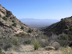
this segment our route traverses a portion of this remarkable range, often nicknamed
simply "the Grahams." Using a combination of foot trails and pleasant forest roads,
the GET follows the main northwest-southeast trending ridgeline, passing near
scenic Riggs Lake, climbing forested Webb Peak (10,030'), and passing within range
of the historic summer cabins at Old Columbine, before descending sharply along
the range's dramatic east face toward the Gila Valley. The route bypasses the
summit of Mount Graham itself, as the trails there are presently off-limits for
the purpose of protecting one of the mountain's rare fauna, the Mount Graham red
squirrel, found only here. For nearly two decades the mountain and its endangered
red squirrels have been the subject of unlikely controversy between wildlife conservationists
and the astronomical community, since the Pinaleños are also now home to the Mt
Graham International Observatory, and indeed the dark, clear skies atop the range
make this among the world's premier locations for stargazing. Nature and science
appear to be coexisting for now, however harmoniously; hikers will note the telescope
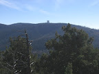
housing atop one of Mt Graham's sub-peaks from several vantages along the route. In
June and July of 2004, the lightning-caused Nuttall Complex fire burned some 30,000
acres of forest and brush, mostly on the Pinaleños' steep east-facing slopes.
This fire and attendant erosion have caused considerable damage to the trail network
as well as the ecology on this part of the range. Thankfully, Ash Creek Trail,
which the GET uses here, received major trail rehabilitation in 2009 and 2010,
resulting in a much improved hiking experience. (Forested Ash Creek Canyon was
largely spared the direct effects of the fire, but not the subsequent flooding.)
(See Travel Alerrt above - the 2017 Frye Fire, some 13 years later, ultimately
tested the resilience of Ash Creek Canyon to the break point.) Still, several
small burn areas and sections of vague or overgrown tread create ongoing challenges
elsewhere in this segment; in addition to this guide description and the topo
map set, plan to pack along an adventurous attitude - the rugged scenery here
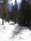
will reward those who are willing to persevere. Spring
season snowpack potentially poses another challenge. Snow on the Pinaleños often
lingers above 9000 feet well into April, or later following an especially wet
winter. As such, hikers at that time of year can expect to encounter at least
some snowpack between milepoints 9 and 21 in this segment, and may want to remain
open to the idea of detouring to avoid some or all of it. The primary concerns
are the labor of postholing through saturated spring snow and the challenge of
following snowbound trail, although slope exposure may also be of concern near
Clark Peak, largely avoidable with care. Refer to the route details below for
more specific info, as well as the Snow Travel
chapter of the GET Trek Planner.
ROUTE
DETAILS Hikers
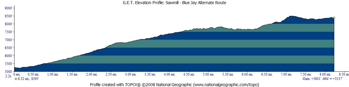
intending to traverse this entire segment may prefer to make use of the Sawmill
- Blue Jay Alternate in the segment's early miles. This alternate route avoids
Johns Canyon Ridge Trail 313, which can be difficult to follow for a mile or more
due to ill-defined and overgrown trail. Elsewhere this primitive trail may be
in more reasonable condition, if a bit vague and brushy. The Trail 313's allure,
compared with the alternate route, is that it offers a more trail-intensive, scenic,
and remote hiking experience on the way up to the crest. It may be particularly
attractive to westbounders, who get to descend this trail from the crest so are
less affected by its scant water resources (see below). In any case, the main
route of the GET - between MP 0 of this segment and its reconvergence with the
Sawmill - Blue Jay Alternate at MP 7.4 - is described first, below, followed by
the alternate route description. Whichever way you opt to begin this segment,
be sure to avail yourself of the water often found in Tripp
Canyon - described at the start of the Sawmill - Blue Jay Alternate
Route description - as there are few convenient, reliable sources between here
and Riggs Lake 14 steep, uphill miles away. To
follow the main route of the GET between MP 0 and 7.4 in this segment, rather
than the Sawmill - Blue Jay Alternate Route, take FR 675 southwest (from the unsigned
junction with segment 9's 2-track road (waypoint 09160, elev. 5260'). FR 675,
a pleasant, little-used 4WD track, heads up the pinyon-juniper-live oak-shaded
bottom of Tripp Canyon, soon crossing the main drainage to follow its north side
(water in wetter times). It crosses back in
about a half mile, near where the side drainage of Johns Canyon enters from the
left (water in wetter times). Above this confluence,
the main canyon changes names from Tripp to Bellows Canyon. Ignore several left-forking
tracks off the main road, which gradually climbs with the canyon bottom. Note
occasional camping potential near roadside in this area - a safe enough bet for
solitude. FR 675 ends at a small "turnout" (if that) along the boulder-strewn
east bank of Bellows Canyon's drainage (1.2, waypoint 10015), the unsigned
trailhead for Johns Canyon Ridge Trail 313. Possibly
marked by a cairn but otherwise unsigned, Trail 313 first runs south through woods
near the drainage's left bank, then crosses it in less than a tenth of a mile,
follows along it briefly, then makes a sharp right away from the drainage at a
t-junction of sorts. The wide swath of a trail eventually meets the drainage again,
narrowing to a primitive pack trail. Soon note an old stock trough, no longer
functional, and a little cement dam, which
holds back a modest-sized pool of good water in wetter times (other times dry).
Natural pools and drainage flow at a final
drainage crossing (1.8, waypoint 10020) are likewise ephemeral, though
fairly likely in early to mid spring following an average or better winter. Top
off water bottles if fortunate here, as Riggs Lake is your next likely near-route
water source. Trail
313 soon switchbacks out of the drainage bottom - leaving it for good - and begins
a sidehill ascent of the canyon's west slope. Although somewhat brushy with live
oak, manzanita, and mountain mahogany, the tread along this portion tends to be
good and the trail is fairly scenic. Occasional blowdowns pose just a minor nuisance
as the trail gains elevation, eventually trending east through a shady side canyon,
then up to a pleasant saddle, with camping potential (3.4, waypoint 10030,
elev. 6803'). The trail leaves the saddle at the 10 o'clock position (southeast),
where it runs near a fenceline for a time, with impressive first views away to
the south and west that include upper Aravaipa Valley and the Galiuro Mountains.
(Westbounders, the trail descends from the saddle on its north side.) Now
the trail sidehills around a steep portion of its namesake Johns Canyon Ridge,
bending southeast and then south, and deftly negotiating around several crags,
more of which are visible in Johns Canyon below. FR 286 can also be seen from
this area, its torturous bends gouged from the ridge beyond Johns Canyon. The
trail becomes increasingly faint due to lack of use and occasional obscuring deadfall,
but remains followable with care. Top out on the forested crest of Johns Canyon
Ridge at 4.4 (waypoint 10040, elev. 7143'), and follow it southeast, the
trail playing hide-and-seek among corridors of brush. At 4.7, watch closely
for where the trail leaves the ridge crest on the left (the crest becomes impassably
steep), again sidehilling, though awkwardly now. (GPS at MP4.7: 32 44.014 110
03.498) (Westbounders, join a narrow portion of the ridge crest at this waypoint
and follow the ridge south to 4.4, where the trail leaves the ridge again to sidehill
once more on its right side, and gradually improving in character.) For
the next half mile or so the trail is considerably harder - sometimes impossible
- to follow, due to an old burn scar (albeit regenerating well) and attendant
erosion of the tread, brushy regrowth, and the like. Watch for flagging and cairns,
and follow this description carefully. After briefly contouring southeast on a
sidehill slope from 4.7, the trail climbs south and quickly becomes lost among
the oaks. However the tread resumes several yards in elevation higher along the
slope to your right - look for flagging leading up there, or seek out an obvious
copse of mature saplings with a little tunnel recently "lopped" through
it. (Westbounders, losing the trail beyond this copse, head directly downslope
a few yards then turn left along your original bearing to soon relocate tread.)
The trails contours
south through the copse of saplings to begin a section of switchbacks that head
generally up the broad "drainage" here. However some of the switchbacks
have been lost to time and the elements. In any case, look for flagging, which
first leads steeply uphill without the aid of switchbacks. Then, several switchbacks
later, the trail turns sharply left by a low-branched Douglas fir. If you accidentally
continue straight here, you'll reach some prominent outlooks to the south and
west but will need to turn back as the side trail leading there abruptly dead-ends.)
(Westbounders turn right by the Douglas fir.) Again
the trail becomes faint as it heads directly up the broad ridge, now in a more
open area. Soon, though, at around 5.1 (waypoint 10045), we are finally
relieved of trail-finding duties, as a 2013-maintained section of tread emerges
- slowly at first, and then definitively - granting comparitively easy passage
via defined switchbacks up the remainder of the steep slope before us. As the
grade slackens, the trail meanders out toward a westward aspect offering far-flung
views, then returns, contouring up to a prominent cairn on a ledge (GPS: 32 43.970
110 03.127). The
trail turns right (south) just above the ledge cairn to pick up the sidehilling
trail. More cairns soon greet you at another turn - this time left (west). Now
a line of cairns marks the trail at intervals leading to a broad, park-like setting
with scattered pines, some with i-blazes cut into the bark. Again the trail turns
- here toward the right (south) - ascends a little rise, then contours with sporadic
cairns toward a somewhat faint switchback that climbs left (west). Trail 313 soon
reaches the edge of the old burn area, heading obviously back into mixed conifer
forest cover at GPS: 32 43.906 110 02.907 (MP 5.8). Good camping
prospects are in the vicinity. (Westbounders, from this waypoint follow faint
tread west to a switchback, then look for cairned trail contouring north, soon
over a little rise, then dipping to a park-like setting. Here note i-blazes on
trees with cairned trail heading west, then turning south to reach a prominent
cairn on a ledge, with GPS waypoint listed in the previous paragraph above.) Routefinding
challenges - and most of the elevation gain - now behind you, follow Trail 313
as it wends its way west and south, first back into park-like terrain to a minor
saddle with camping prospects - then on a brushy westward contour. A junction
with Durkee Ridge Trail 323 at 5.9 may feature an old, fallen signboard.
Another signboard, still standing at last check, marks the junction with equally-moribund
Trail 312 farther ahead at waypoint 10060, with a reference to Coulter
Spring (2500 vertical feet below according to maps, unvisited). Our
trail - still Johns Canyon Ridge Tr 313 - turns left at the sign, climbing through
another old burn area via several cairned switchbacks, and ending at a signed
trailhead turnout along 4WD West Peak Road at 6.4 (waypoint 10070, elev.
8587'). (Westbounders, turn left into the turnout for Trail 313 just before
West Peak Road goes through the notch on the ridge.) (A brief detour south
on West Peak Rd (aka FR 286) leads to a gated side road accessing the summit of
West Peak and its old firetower, which may be locked, but the views are good from
ground level, as is the camping, albeit dry except when rain has been plentiful,
when you may find harvested runoff water in a metal storage
can along the back wall of the fire watch's cabin located 100 yds east
of the firetower. Lookout Spring, located
in the trackless headwaters of Johns Canyon, was unfindable in 2006.) From
the Trail 313 trailhead turnout, West Peak Road heads southeast, downhill, with
the undulating backbone of the Pinaleño crest unfolding away toward still-distant,
higher Mount Graham. The little-used but well-defined dirt road soon bends northeast,
descending easily through open forest and meadow. It rounds the south-facing flanks
of Blue Jay Peak, which are incised by several shallow drainage heads. Watch carefully
just downslope from the road for Government Spring, a
cement tank in an ancient corral, which is worth a look but rarely holds any usable
water, and the surrounding drainage is typically damp at best. A bit more than
a tenth of a mile beyond, at 7.4 (waypoint 10120, elev. 8325') an unpretentious
signboard for Clark Peak Trail 301 on the right heralds our soon return to foot
trail. (Main route description resumes below Sawmill - Blue Jay Alternate Route
info below. See the end of the Sawmill - Blue Jay Alt. description for more info
about potential water options in this area.)
ALTERNATE
ROUTE: SAWMILL - BLUE JAY
| ELEVATION
PROFILE | 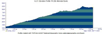 |
The 8.3-mile Sawmill
- Blue Jay Alternate begins at MP 0 (waypoint 09160, elev. 5260') of the main
route in Segment 10 and follows a combination of Forest Route 286 and an old waterline
trail in secluded Sawmill Canyon, trending uphill in the north-facing shadow of
West Peak. An option exists to then remain on FR 286 all the way to the top of
the 8700-foot peak and a resumption of the main GET just beyond, while the Sawmill
- Blue Jay Alternate itself leaves the road part-way up in order to rejoin foot
trail again as soon as possible (Blue Jay Ridge Trail 314). Use of the Sawmill
- Blue Jay Alternate Route adds about a mile to this segment's total length as
stated at the head of this page, though without the routefinding concerns and
dryness associated with the main route on Johns Canyon Trail which it bypasses. Begin
by heading west on FR 675 and passing through a vehicle camping area in forested
Tripp Canyon. In 0.1 mi, at a junction, (signed in 2010) (waypoint 10010, elev.
5200') FR 675 meets better FR 286, onto which we turn right. (Water is often available
just east of this junction and left of the parking area; continue past a concrete
slab then down into the main drainage of Tripp Canyon,
a grassy stringer among sycamores. Waypoint 09155. If the drainage is polluted
by cattle, seek out a small corral at the east end of the car camping area, where
a trough with float valve sometimes holds
good water. More water is potentially ahead, along the alternate route itself,
at MP 0.5 and again at 2.4 and 2.8) 2WD
FR 286 climbs out of Tripp Canyon toward the southeast. Just before it bends sharply
right at 0.5, note the first of two side roads on the left (east). The first is
typically a faint 2-track road and it dead-ends at a pipe-fed
water tank in a hundred yards or so (waypoint 10072). The camo-painted
metal tank is open on top and was filled to the brim with good water from way
up Sawmill Canyon on first observation in Fall of 2014. Our alternate route follows
the waterline for the next 2 miles, but to do so, first return to FR 286. Turn
left on the main road here, then just ahead note another side road on the left
(0.5, waypoint 10074). Take this 4WD track, which heads southeast. The
track becomes increasingly primitive and eroded, by and by discouraging vehicle
use, until crossing a side drainage of Sawmil Canyon, beyond which it is effectively
a pack trail (and not eroded). The
trail continues to follow the waterline, both an old metal pipe - now defunct
- and a newer, synthetic one of the standard rancher variety. Increasingly secluded,
the sunny canyon bottom is initially the realm of live oaks and scattered pines,
but gradually assumes the character of a more coniferous forest fittingly named
for a sawyer's trade (no evidence of an actual historic sawmill was noted), and
affording good camping opportunities along the banks of the normally-dry drainage.
Eventually the primitive but easygoing waterline trail commits to the opposite
(eastern) side of the drainage, still ascending at a gradual pace, as it approaches
our departure point at around 2.4 (waypoint
10076). This is where we'll ultimately climb out of the canyon bottom en route
back to FR 286, which we'll accomplish by way of the "connector trail"
indicated on the map. At waypoint 10076 note an open area along the banks across
the drainage to the west with cut logs, as if from a blowdown removal operation.
This is the vague terminus of the trail, which is more of a wide swath here. With
this departure point in mind, now continue up the waterline trail another 100
yards or less in search of Sawmill Spring,
an area of good trickling pools in the rocky drainage (waypoint 10078). (Maps
show the spring farther north, down the canyon, but no water has been noted there.)
You should hopefully find water where described and won't need to continue farther
up the drainage around a cliffy obstruction (which the waterline climbs over),
although water may also be present above this area (where the waterline actually
terminates is unknown). Back
at the connector trail junction at 2.4 - which may feature a cairn - climb out
of Sawmill Canyon via the wide swath on a steep switchback. This connector soon
reveals itself to be a hodge-podge of actual trail and open drainage travel, with
the trail serving to link a series of low-angle side drainages that lead uphill
away from the bottom of Sawmill Canyon. The way forward should be mostly self-explanatory.
The climb ends with another steep section of "swath" that opens into
a sunny ponderosa flat. This is the Dry Lake Tank undeveloped camping area, seldom
used by vehicles outside of hunting season. Follow a dirt road around the west
side of Dry Lake Tank itself, a manmade pond
that ironically holds water with some frequency (waypoint 10090). (The tank isn't
reliable in times of drought, though. And in any event, better quality water is
usually available at Sawmill Spring.) Beyond the tank, keep left as the "campground"
road occasionally splits, to a rejoining with FR 286 at 2.9 (waypoint 10080).
(Westbounders, where FR 286 meets the Dry Lake Tank undeveloped camping area
at 2.9, follow the "main" road (FR 286A) through the "campground"
to Dry Lake Tank (waypoint 10090). Then walk
southeast from the far end of the tank into the head of a minor drainage. A de-facto
trail starts here and heads down the drainage, which soon steepens. Take the most
obvious line of travel - a combination of trail, swath, and x-c in the drainage,
finally bottoming out in the main drainage of Sawmill Canyon at 2.4 (waypoint
10076). Cross the drainage to find an impromptu waterline trail and adjacent black
pipe. Now head up the canyon bottom to find Sawmill Spring within 100 yards, several
pools and some possible flow in the rocky drainage. The Sawmill - Blue Jay Alternate
proceeds back down the waterline trail for 2 miles.) Follow
FR 286 south as it climbs at a noticeable grade among lush mixed conifer forest.
The dirt road becomes increasingly primitive, especially beyond milepoint 4.5,
where it's essentially 4WD-accessible only. Here, at a switchback in the road,
(waypoint 10100) the main GET route turns left onto Blue Jay Ridge Trail 314.
(A new trail sign was installed here in 2013, but the mileages and destinations
shown were incorrect.) Blue Jay Ridge often holds snow into spring, but the route
is very scenic and biologically diverse, and also the trail received a work crew
in 2011, helping to improve - but not eliminate - its inherently primitive condition.
(Otherwise, one could remain on FR 286, passing close by the summit of West Peak
and its viewful summit firetower. At the height of land, FR 286 becomes West Peak
Road and immediately passes the upper trailhead for Johns Canyon Trail 313, where
resumes the main GET route eastbound via West Peak Rd.) Joining
the Blue Jay Ridge Trail, note the forest of spruce, hemlock, and douglas
fir - exceptionally lush for the 7500' elevation, and more typical of the environment
near Webb Peak ahead in this segment. The trail contours around the drainage of
Sawmill Canyon, then turns northward onto a sunnier slope, where the vegetation
quickly changes to ponderosa, gamble oak, mountain mahogany, and beargrass, and
interesting views open toward the Santa Teresas. Contour
along the base of a rocky bluff to gain the crest of Blue Jay Ridge by a trail
sign at 6.4 (not a junction). Turn sharply right (south) and continue on
the trail, switchbacking briefly uphill, then dipping to a camp-friendly saddle
among the pines (waypoint 10115). The views along this side of the ridge, down
to the Gila Valley, are deep and impressive. The trail now ascends rather roughly
with the aid of short switchbacks, descends to another saddle, then switchbacks
uphill again, taking the only feasible line through this difficult terrain. Top
out just shy of peak 8529, then descend moderately to reach the trailhead at the
end of West Peak Road. (7.8, waypoint 10118). When snow is melting you
might find a little rill in the shallow drainage
just before trailhead. Follow
4WD West Peak Road south, with expansive views of the Pinaleño crest ahead.
About 100 yards after passing through an open gate, rejoin the main GET route
and turn left off the road onto Clark Peak Trail 301. (8.3 of alternate
route, waypoint 10120, elev. 8330') (Westbounders, turn right here to follow
the Sawmill - Blue Jay Alternate Route, or left to follow West Peak Rd on the
main GET route.) This is milepoint 7.4 along the main GET route.
Government Spring, a cement tank in an ancient corral, visible just
downhill off West Peak Road to the west, rarely holds any usable water, and the
surrounding drainage is typically damp at best.
Back
on the main GET route, (7.4, waypoint 10120, elev. 8325') Clark Peak
Trail 301 begins on an old road bed closed to vehicles, but soon becomes a more
definitively singletrack trail. (This trail received a work crew in 2010 as far
as Taylor Pass, as well as the last 2 miles to the eastern trailhead along FR
803.) Improved with occasional cairns, the trail descends a southeastern ridge
of Blue Jay Peak among pinyon pine, live oak, and manzanita toward Taylor Pass,
with frequent short switchbacks easing the gradient. Hikers in desperate need
of water might consider bushwhacking over to Manzanita
Spring (map-derived waypoint 10130), an unverified source; otherwise,
your best bet would probably be to avoid the extra effort and press on with a
purpose toward Riggs Lake (or Sawmill Canyon, for westbounders). A
barbed wire fence follows the ridgeline at Taylor Pass (9.2, elev. 7150',
waypoint 10140). Eastbounders here turn left to pass through a gate in this fence,
rather than continue more obviously straight on Trail 306. Once through the gate,
continue eastbound on Trail 301 up along the ridge. (Westbounders would likewise
turn left through the gate, then right to remain on Trail 301.) Trail work
was incomplete between Taylor Pass and about milepoint 10.5, so the trail was
rougher here, and especially so beyond another saddle at 9.7, also with
potential camping prospects. Continue climbing via switchbacks, now entering a
portion of the Taylor Fire burn area. The unmaintained switchbacks may be eroded
and rather indistinct, though the route should be more or less obvious due to
user traffic and/or flagging tape. After the first set of switchbacks the trail
rounds the east side of the ridge then climbs via more switchbacks through some
thorny vegetation and gamble oak. Some impromptu whacks and cuts at the vegetation
had helped to define the trail corridor here. The trail reaches the edge of a
meadowy area near 10.5. The next half mile continues through an older,
more extensive burn, now mostly recovered by grasses and ferns, where occasional
large cairns help guide the way. Better
trail resumes about half way through the meadow area. Heading back into living
forest beyond a height-of-land, Trail 301 contours along a west-facing slope,
which tightens into a narrow ridgeline defined by the rocky prominence of Clark
Peak. The Carter-Nuttall Trail, which heads downhill to the north at 11.4
(elev. 8600'), might (or might not, depending on trail conditions) offer a bomb-off
option for springtime hikers confronting snowpack around Clark Peak, where the
trail is forced to weave back and forth on either side of the crest. (Another
unconfirmed bomb-off is back at Taylor Pass, where the North Taylor Trail 306
heads downhill to the north.) Often, however, the spring snowpack ahead can be
negotiated, for example where the trail crosses the ridge to its east side, by
leaving the bench-cut trail to climb directly up the slope among the comparitive
safety of the trees. The trail can then be regained where it intersects the main
ridge once again, crossing back to its sunnier west side. Reach
the trailhead terminus for Clark Peak Trail 301 at 12.6. This is also the
terminus of FR 803, more popularly known as the Swift Trail. Constructed by the
Depression-era Civilian Conservation Corps, this portion of the scenic road (graded
dirt) is accessible to passenger vehicles when open, typically mid April to mid
November. Traffic is generally very light. The rest of the year the road is gated
and often snowbound. The suggested route of the GET actually joins up to follow
the Swift Trail in about a mile; instead it follows a more primitive road from
the trailhead area: signed FR 730, which heads south, forming a semi-loop with
the Swift Trail. FR 730 passes near an expansive westward outlook over the Sulphur
Springs Valley, then heads more easterly where we encounter an equally expansive
copse of quaking aspens, among the finest such stands on the mountain range. Meadowy
campsites are found near an unsigned junction with another 4WD road heading south.
The GET continues east on FR 730, which then bends left, north at another junction.
During snowmelt season in spring you may find water in the adjacent
drainage. FR 730 ascends gradually with the drainage (side roads head
to vehicle camping spots), topping out at its terminus with the Swift Trail once
more, at 13.6. The
GET now joins the Swift Trail's graded dirt track, proceeding southeast, and occasionally
by dispersed camping areas along the road, to reach a signed junction with FR
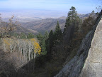
287 at 14.0 down to Riggs Lake. The
first reliable water in this segment, the manmade lake is located in a very attractive
forested setting, and even sports a small sand beach. At the very least, pause
to fill water bottles here as needed, then continue along the Swift Trail. (The
lake's inlet, along its eastern shore, a small, pristine creek that drains from
a densely forested area, may also be reliable.) The
road arrives at the pleasant meadow of historic Chesley Flat at 16.1 (waypoint
10220, elev. 9260'), named for a pioneer-era family who lived and worked on the
mountain. Here the unsigned Chesley Flat Trail 311 leaves the road at left (east-northeast),
the main route of the GET, bound for 10,000-foot Webb Peak and its scenic lookout
tower. (However, in springtime of heavy snow years, hikers may prefer
to remain on the Swift Trail, which keeps generally below 9500', rejoining the
main route below the Ash Creek trailhead at Columbine Corrals. Distances are comparable
along either route.) TRAVEL
ALERT: Due to flooding in Ash Creek as well as burn damage in its headwaters around
Webb Peak, hikers should leave the main route of the GET either at 16.1 or at
17.3, then follow the Ash Creek Bypass Route as shown on the most recent (version
3.3) GET Topo Mapset. Read ahead to the end of this chapter for an overview of
the alternate route. Indistinct
at first, Trail 311 skirts the southern edge of the meadow, ducking into the woods
within 50 yards or so, then reaches a signed junction with Blair Trail 304. Keep
right here, remaining on Chesley Flat Trail 311, which begins a switchbacking
climb through a dense forest of spruce, fir, and aspen. This section of the trail
saw maintenance in 2010; previously Trail 311 had served as a successful fire-break
during the large Nuttall Complex Fire of 2004, helping to spare the forested west
side of the range a similar fate as the east, but the trail was tree-littered
and hard to follow as a result. As the grade slackens, the trail heads along the
height of the broad ridge in an open area just out of the forest, the burned terrain
to the north offering up distant views. Chesley Flat Trail 311 ends at a signed
junction with FR 88 at 17.3. Follow
FR 88 (closed to vehicles) to the summit of Webb Peak (milepoint 17.5),
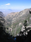
at 10,030 feet the highest point on the GET in Arizona. Views from the top of
the fire tower are all-encompassing: to the south rises Mt Graham with its summit
telescope housing plainly visible; on the western horizon, the rugged profile
of the Galiuro Mountains frames more distant Rincon Peak, the Santa Catalina and
Santa Rita Mountains; northward stand the Santa Teresas and Pinal Mountains; eastward,
the folds of desert ranges along our route extend to the edge of Gila Country,
while the town of Safford lies some 7000+ vertical feet below, alongside the Gila
River on its long and adventurous (and sometimes subterranean!) journey from New
Mexico to California. Find
Webb Peak Trail 345 by a trail sign behind the lookout cabin. The trail descends
eastward, soon reaching a junction where the trail splits (forming something of
a loop trail from Ash Creek trailhead). The left (northward) option, the main
GET route, is somewhat nicer for its varied forest and how it keeps to the backcountry.
(However, this portion of the loop probably holds onto snowpack later in the
season, so the other fork, trending southeast toward Ash Creek trailhead, may
be the better choice in heavy snow years. It reaches the trailhead in about a
mile, from which Ash Creek Trail starts north. In addition to the hiker/equestrian
trailhead, this area serves as a developed campground (fee), with tables, fire
grates, and vault toilets.) The main GET-fork of Webb Peak Trail trends north
downhill through several switchbacks, briefly in burned terrain here, then crosses
the first of several pleasant rills, likely flowing in springtime and following
monsoon rains. It now heads more directly down a forested ridge, then eases into
an eastbound-trending contour. This trail apparently saw a blowdown crew in 2010,
as evidenced especially by the big log cuts on the final descent toward the southeast,
where it joins up with Ash Creek Trail 307 (19.4, waypoint 10280, elev.
9120'). Traveling
from the pines and aspens all the way to the desert below, Ash Creek Trail descends
4800 net vertical feet in nearly 7-8 miles, a prolonged and noteworthy grade,
certainly, but also a remarkable one thanks to nature's handiwork on display in
Ash Creek Canyon. Ahead lie waterfalls, towering pinnacles, and much of the mountain
ambience that one associates so fondly with the American West. But be forewarned:
due to the shady northeastern exposure here, residual snowpack may persist in
springtime all the way down to the 8000 foot elevation; plan on a pace of no better
than one or perhaps 1.5 miles per hour when snow is a problem. (A detour via AZ
366, with a possible hitchhike into Safford about 35 miles away by road, may be
worth considering when the trail here is deeply snowpacked. AZ 366/Swift Trail
is generally open to vehicle travel all year along its paved portion, which begins
about 7 undulating miles beyond the turnoff to Columbine Corrals.) Trail work
on Ash Creek Trail in 2009 and 2010 provided a smooth, well-defined tread with
very few obstacles, for as long as it lasts. Trail
307 immediately crosses perennial Ash Creek
at 19.4 (westbounders join signed Webb Peak Trail 345 at the junction
to follow the main GET route up to Webb Peak). An old relict here must be
a boiler for a steam engine commonly used by early logging operations. Ash Creek
tends to be lively and cold during the snowmelt season, though is usually manageable
with care. Continue downhill on Trail 307, gently contouring and notably wide
ahead as it follows a former logging route. Cross a tributary of Ash Creek at
19.4, where a side trail points up the drainage to the Southern Arizona
Bible Camp surrounded by national forest land (the trail is virtually non-existent
after a few yards). Ahead, Trail 307 fords Ash Creek
again, here at the site of the former Mount Graham sawmill, now a pleasant sunny
meadow with fine camping prospects. At
20.6 (waypoint 10300), the recommended GET route turns left, climbing out
of the drainage on the Ash Creek "bypass trail," while the old Ash Creek
Trail itself continues down the drainage toward Ash Creek Falls and "Slick
Rock," a sloping creekside monolith which the trail has been engineered to
cross. However, this drainage-hugging section of trail in recent years has been
damaged by floods and is potentially unsafe during times of higher water. (In
2009 the so-called bypass trail had been resigned as the main Ash Creek Trail,
and the old drainage route abandoned - at least officially so; in reality, it's
still a popular route for "locals" on a warm summer day.) The
"bypass trail" ascends the sunny southeast-facing wall of the canyon,
offering a potential reprieve from any snowpack. The gradual, traversing climb
gives way to a switchbacking descent, presenting good views of the canyon below
and Pinaleño crest above. Return to the main Ash Creek Trail by a brown
sign with an arrow on it at 21.3 (waypoint 10310). Turn left here at the
switchback (or right, to check out the lower end of the Slick Rock feature, with
its pretty cascade). (Westbounders, to proceed on the recommended GET route,
turn right, heading uphill at the switchback.) Now
Trail 307 traverses north, perhaps again with snow patches in spring. Look and
listen for 200-foot-high Ash Creek Falls in the drainage far below; you can edge
your way down a short use-trail to an outcrop overlooking the falls, but for safety's
sake consider dropping your pack first. Views ahead to the lower peaks and ridges
of the range present a striking scene, with the massive granite exposures of The
Pinnacles especially impressive. Shingle Mill Mesa Trail heads left at 21.7
(waypoint 10320, elev.7640'), the T-junction marked by a dilapidated wooden signpost.
(Westbounders, turn left here, remaining on Trail 307.) A long series of
short switchbacks doesn't quite relieve the steep descent back down to Ash
Creek on our Trail 307. Reach the drainage at 22.1 near a possible
campsite (elev. 7049'). The
trail was formerly flood-damaged and quite rough as it headed down the drainage
from here, but was in good shape following aforementioned trail maintenance. Nevertheless,
the footing tends to be rocky, with frequent fords of Ash Creek, and with little
climbs and descents in between. Pass
the first good camp at Oak Flat - on the left (west) side of the creek - at 23.2
(waypoint 10340). This is one of the few feasible spots to camp until reaching
Ash Creek Road at segment's end. It's also a good spot to watch for raccoon-like
coatimundi, which sometimes forage in large packs along the open forest floor.
A seasonal spring sometimes floods the trail
just ahead, slightly more accessible than Ash Creek itself. Finally the trail
leaves the drainage for a spell, descending along viewful switchbacks. Near the
steeply-graded bottom of the pitch, up-close views of a spirited cascade delight
the senses, before the trail returns once more to the drainage (24.2, elev.
5646'). For its
elevation, the creekside forest of Douglas fir and ponderosa pine remains surprisingly
lush as you persevere in the drainage for just a little longer. With a final crossing
of Ash Creek at 24.9 (waypoint 10360)
the trail promptly climbs out into the surrounding high desert, contouring east
along open slopes. A northward tack on good tread soon reveals the full grandeur
of Ash Creek Canyon and of the Pinaleños' eastern face in total - a great,
towering upheaval of granite and gneiss. Trail
307 at last descends a low, blocky ridge to reach 4WD Ash Creek Road by a cairn
and metal post at 25.9 (waypoint 10370, elev. 4672').
| ELEVATION
PROFILE | 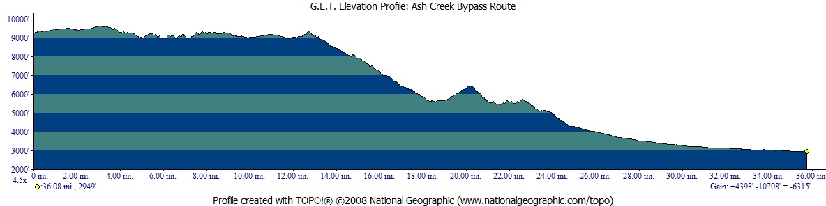 |
ALTERNATE ROUTE:
ASH CREEK BYPASS ROUTE TRAVEL
ALERT The
2017 Frye Fire
and subsequent flooding in the Pinaleño Mountains has left the GET severely
damaged in and along Ash Creek (from approximately mile 17.5 to the end of this
segment). Trail conditions are verified hazardous, with some *class 4 climbing*
necessary due to the tremendous degree of erosion. The GET will probably be permanently
relocated away from Ash Creek, but a finalized reroute has yet to be determined.
In the
meantime, please use this temporary bypass route in order to complete Segment
10. This bypass is 36 miles in length, starting at GET Segment 10 mile 16.1 and
ending at Segment 11 mile 9.7. The bypass route is thus 16 miles longer than the
portion of the main GET (original route) it replaces. Hikers should plan their
food carry accordingly and be prepared to hike a somewhat unvetted route (which
nonethless should be much safer and easier than the main / old route at this time).
The bypass route does encounter patchy burn conditions from the Frye Fire along
the way, but likely nothing particularly problematic. There is also an "all
roadwalking" option available via the Swift Trail (AZ Rte 366) that should
be very straightforward. In
abstract, from Chesley Flat the Ash Creek Bypass Route follows the Swift Trail
(aka graded dirt FR 803 / AZ 366) for 5 additional miles, with likely water at
Peters Flat, Post
Creek (the drainage below Hawk Peak Spring) and Moonshine
Creek. It then optionally joins a network of old logging roads that
widely parallel the Swift Trail on its east side, mainly for the sake of more
primitive tread, although the current condition of these roads is unknown. The
headwaters of Grant Creek may offer water
here. The route then rejoins the Swift Trail for an additional 2 miles, or you
might be able to use the Grant Hill trail network and other jeep roads and/or
cross-country travel to again roughly parallel the Swift Trail for a more aesthetic
experience (albeit the Swift Trail is a pretty nice walk itself). Water would
normally continue to be available at regular intervals throughout this area. Joining
Arcadia Trail (a National Recreation Trail), the alternate route enters the old
Nuttal Fire burn zone from 2004. Some of this terrain likely burned again in the
Frye Fire, and although trail conditions were reportedly good just prior to the
Frye Fire, it's possible that this has changed or could change in the future.
So, if you happen to find the way ahead problematic, you could opt to remain on
the Swift Trail, intercepting the bypass route again farther ahead (a couple of
caveats being that the Swift Trail is paved ahead and is normally open year-round
to vehicle traffic, whereas the graded dirt portions are gated to vehicles between
November 15 and April 15 annually). The
most primitive portion of this trailed section of the bypass is likely to be along
upper Noon Creek Ridge Trail, if not directly due to fire then simply because
it receives less use and maintenance. If this trail is an issue, then continue
on Arcadia Trail down to Arcadia Campground and join the Swift Trail there, taking
it for as long as you deem necessary. Both Wet Canyon
and Noon Creek often have water. By the time
the route joins Round-the-Mountain Trail, elevations are sufficiently low that
forest (burned and unburned) has given way to a much more open transitional environment.
This part of the mountain burned in the Frye Fire as well, but the negative impacts
should be lower overall. Find water in Marijilda Creek
and Gibson Creek, and then near the bottom
of Gibson Canyon Trail where, some 13 miles after joining trail at upper Arcadia,
the bypass trades trail tread for mostly dirt roads the remaining 10 miles to
the outskirts of Safford and a resumption of the main route in Segment 11. Views
up to Mount Graham are all-encompassing here along the edge of the Gila Valley,
but plan to tank up on water before leaving Marijilda environs as the low desert
front country tends to be dry with very limited exception. Eastbound,
rejoin the main route of the GET in Segment 11, mile 9.7 (skip ahead to this part
of Guidebook Chapter 11 to continue reading). And please refer to the most recent
version of the GET Topo Mapset (3.3) maps 31-34 for further details on the Ash
Creek Bypass Route. |