G.E.T.
Guidebook
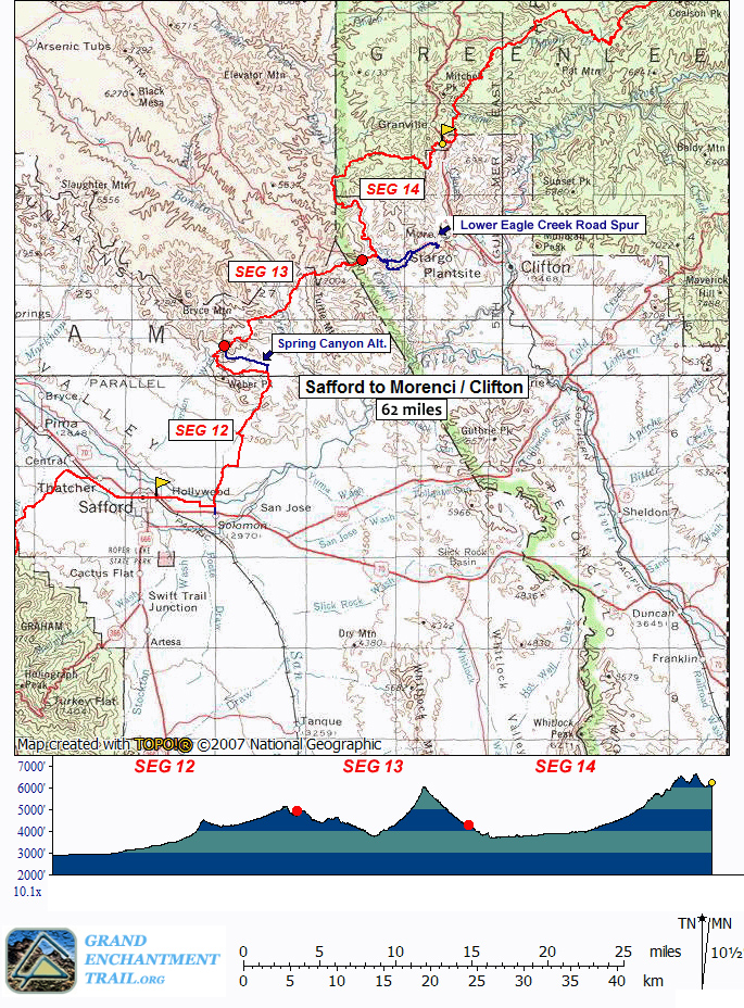
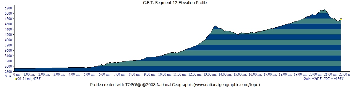
Segment 12: Gila Valley North 21.9
miles
 Guidebook
Home Guidebook
Home
Open
this page for printing
Submit
feedback for this segment
|
Segment
Length
|
Segment
Status
|
Season
|
|
|
|
21.9
mi.
|
finalized
and accessible
|
fall,
winter, spring
|
| Resources |
|
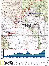
OVERVIEW
MAP
|
 |
|
ELEVATION
PROFILE
|
 |
G.E.T. Topo Maps 35-37
Town Guide: Safford
Water Chart
Image Gallery: Album
4
|
Additional
maps:
Safford 1:100K Topographic (BLM)
Land management agency:
BLM Safford Field Office
|
| Beginning
access point |
|
Ending
access point |
|
US
70 at 8th St & Hollywood Rd. The GET crosses US
70 here, a half mile east of downtown Safford. Free, long-term
parking may be available in town; inquire at the Chamber
of Commerce office on US 70 between 8th Ave and 14th Ave
(with a large parking lot nearby), or at the USFS/BLM office
on 14th Ave at 8th St.
Alternative
access: Sanchez Rd at Gila bridge. Section hikers with
vehicle support can bypass the first 5 miles of this segment,
which follow pavement and dirt agricultural roads out of
town. From beginning access point above, follow US 70 east
4.3 mi. to Solomon, turn left (north) on Sanchez Rd, and
continue 0.8 mi. to the bridge over the Gila. A dirt turnout
is on the left just beyond the overpass.
|
|
Old
Safford-Morenci Trail west trailhead. From
US 70 (Thatcher Blvd) at 8th Ave in Safford, head north
on 8th Ave. In 1.5 mi. bear right at the fork onto Airport
Rd. and follow it 4 miles to Aviation Way. Turn left here,
then immediately left again onto (unsigned) Solomon Pass
Rd (which becomes graded dirt) and continue 8 miles to the
Solomon Pass-Salt Trap Road junction. Bear left onto Salt
Trap Road and follow it 1.8 miles. Turn left (waypoint 12135;
if you reached Salt Trap tank and corral you missed this
turn) and continue ~4 miles to the signed trailhead, a dirt
turnout with ample parking. A 4WD high-clearance vehicle
may be needed for sections of the last 6 miles.
|
SEGMENT
OVERVIEW
The Grand
Enchantment Trail rejoins cotton-spangled farmland once more as
it departs Safford environs, then ascends gradually out of the
Gila Valley and into the Gila Mountains on our tour of this segment.
The Gila Mountains of Arizona are of course not to be confused
with the Gila National Forest in New Mexico, farther ahead on
our route. This comparatively low-elevation mountain range is
fault-block in origin, a colorful, rock-studded upheaval that
delineates the broad Gila Valley for many miles on its north.
The geology
changes markedly as we enter this high-desert range. Gone from
the surface environment are the sturdy granites, gneisses, and
schists that form the heart and character of the Pinaleños, Santa
Teresas, and other sky island ranges, replaced instead by the
cobbly sedimentary and volcanic rock of the Gila Conglomerate.
As is common throughout southeastern Arizona, the mineral copper
is abundant in this area, a fact that has not gone unnoticed by
mining interests over the years. In 2005, the Phelps-Dodge Corporation
(now Freeport-McMoRan) secured plans to develop a pair of open
pit mines in the Gila Mountains west of our route and only a few
miles north of Safford, a boon to the rural economy here, if in
some ways a transformation of the town's very soul. And so our
route looks on from afar, offering vantages from this range of
the distant past, the heady present, and an uncertain future.
In essence,
this segment is a lead-in to the historic Old Safford-Morenci
Trail which we explore in Segment 13. Along with Segment 14, these
three segments - collectively the G.E.T.'s "mining miles" - make
for a good 3-5 day section hike physically linking the Safford
area with Morenci and the historic mining town of Clfton. Segment
12 here offers the fewest water sources of the three. Be sure
to carry an adequate supply out of Safford, and consider detouring
to the community of Solomon - 5 miles into the segment and about
a half mile off-route - as all of the potential sources in this
segment are either rancher-dependent or otherwise unreliable.
(The Gila River may be fine for "camp water," but would not be
suitable for drinking due to agricultural use of the valley.)
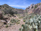
Overall, the hiking route in this segment, a mish-mash of developed
roads, jeep tracks, and drainages, is quiet and sufficiently remote-feeling,
and becomes ever more so as you make tracks into the desert hills
beyond town.
ROUTE
DETAILS
From the 4-way
junction of US 70 with 8th St on the west and Hollywood Rd on
the east, (waypoint 11130, elev. 2920') head east on Hollywood
Rd. The minor paved road passes through the little unassuming
enclave called Hollywood, part residential, part agricultural.
At 0.9
of a mile (waypoint 12000), the arrow-straight road finally bends
toward the south, becoming Montierth Lane. Leave the road at the
bend and continue due east across the northern edge of a cotton
field, keeping an embankment on your left. The way is unimproved
initially, but a dirt farm road comes in at the next field plot
and you can continue east on this. (The farm roads in this area
- little-used except by cotton farmers themselves - are generally
considered public rights-of-way, while just to the north lies
the Gila River's extensive, sporadically wooded floodplain which
is public domain as well, where you could make a pleasant camp.
The floodplain tends to be very sandy, so is not as conducive
for travel.)
Remain at
the very northern edge of cultivated land as the perimeter road
trends east and southeast, crossing a couple of minor irrigation
channels, which can be a little tricky to dry-foot hop when flowing.
At 2.0 (waypoint 12001), the road comes to a t-junction,
with a row of shade trees at right extending south. Turn right
here (south), tracing the eastern edge of the field. In a short
ways you can then pick up an easterly road once again (waypoint
12002). Remain nearly due east on this road, ignoring occasional
side roads at left and right, and continue to its end at a t-junction
(3.1, waypoint 12004). Here turn right (south) to 3.5
(waypoint 12006), then left (east) on a short bridge over the
San Simon River, little more than an irrigation channel here.
(Westbounders, be sure to cross the bridge, THEN turn right
(north) onto the road just beyond.) Remain on this road as
it continues east across more cotton fields, a veritable sea of
white in the early autumn prior to harvesting. Pass a few utility-type
structures at roadside, then reach paved Sanchez Road at 4.5
(waypoint 12008). (Westbounders, leave Sanchez Rd and turn
right onto the first groomed dirt road beyond the Gila River,
left side of an irrigation channel. A road sign warning of "ice
on bridge" is located just north of the turnoff.)
As a detour,
you could follow Sanchez Rd south for 0.5 mi. to reach the small
community of Solomon, which
has a convenience store for water, as well as a post office and
restaurant. (See Town
Guide) Otherwise, turn left (north) on Sanchez Rd. Traffic
is generally light, while more bordering cotton fields lend a
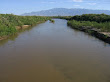
bucolic air. At 4.8, the road spans the Gila River in its
wide flood plain (el. 2950'), with river access available via
either the north or south end of the bridge. Continue north to
the paved road junction at 5.5 and take the left fork onto
Airport Road.
Leave Airport
Rd at 5.7 (waypoint 12030), and join the wide, braided
drainage of Tidwell Wash heading north. (A 2-track just east of
the wash ends within 0.1 mi. in the wash) Generally follow the
easternmost branch of the wash for easiest travel in this cross-country
stretch. At 7.4 (waypoint 12040) a 4WD road crosses. Leave
Tidwell Wash here by turning right (east) on the 4WD, and continue
to 8.4, where a power transmission line and its service
road cross.
At the powerline,
turn north onto the dirt 2-track service road. Pass around the
east side of a power substation at 9.4, ignoring roads
that head west, and continue north with the trans. line. A solar-powered
well just east of the substation may offer a trough
and sometimes feeds water to a stock pond visible to the west
via PVC tubing, from which you may be able to collect good water.
The pond itself seems to receive little stock use and its north
side might make for an ok camp hidden in the brush. Farther ahead
on the powerline road, pass a side track on the left that goes
to another earthen stock tank of unknown reliability. At 10.2,
(waypoint 12060) ignore an intersecting 4WD road at a 4-way junction,
then at 10.5 (waypoint 12070) reach another 4-way with
a lesser road and turn left (west) onto it, leaving the powerline
service road. Cross the wide, sandy course of Tidwell Wash, which
away from the road crossing may offer good, secluded cowboy camping
prospects. The 4WD road ends at a t-intersection with Solomon
Pass Rd, at 10.9 (waypoint 12075). Turn right (northeast)
onto graded dirt Solomon Pass Rd. Vehicle traffic is generally
light. (Westbounders note that the 4WD turnoff, at 10.9, is
the first such option on your left after the corral at 12.3.)
A windmill
and corral appear at left, at the road bend near 12.3.
The corral may contain several troughs
with water now fed by solar power. Cross a cattle guard here.
Just beyond, a lesser road heads right. Don't take it, but instead
continue a short distance on Solomon Pass Rd to the next junction,
at 12.4 (waypoint 12080), where a 2-track roads heads off
at the 2 o'clock position (northeast). Take this 2-track, which
parallels Solomon Pass Rd on the opposite side of the drainage
below the pass. The rocky swath is essentially unused by vehicles,
and is safer than the main road to Solomon Pass, where the two
roads again meet. (Westbounders turn left just beyond the pass
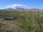
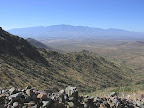
onto the 2-track.) Far-ranging views from Solomon Pass (13.4,
el. 4540') include the Gila Valley, Pinaleños, and Santa Teresas
toward the south and west, while in the opposite direction lies
broad Turtle Mountain beyond Bonita Creek, both destinations northward
along our route.
Proceed north
once more on Solomon Pass Rd, descending among diminuitive high-desert
ground cover to a pair of corrals near 14.1. The second
corral, on the left (west) side of road, has one
or two troughs with float-valves that sometimes hold
water, and have had a good track record in recent years. (The
stock pond of Rattlesnake Tank
itself was not visited.) Soon a 4WD track forks left (waypoint
12110), but continue on graded Solomon Pass Rd to 14.8
(waypoint 12120). Now take the left fork onto (likely signed)
Salt Trap Road. Pass sometimes-wet Don
Tank, downhill to the east, often with cows, and continue
north to 16.1 (waypoint 12130), where the obvious, gravelly
wash of Bear Spring Canyon crosses. (Here the Spring Canyon
Alternate route follows Salt Trap Rd another half mile, then
turns left onto a 4WD road to reach the Safford-Morenci west trailhead
in 3.5 more miles. A solar-powered well
with trough is a possible water source at MP 2.0 of
the alternate. This is the vehicle route to the trailhead, shorter
but less interesting, and potentially offering less solitude,
than the main GET route.)
The main route
turns left (west) to follow the rocky, braided wash of Bear Spring
Canyon (not Spring Canyon, mentioned above). Negotiate
a wire fence across the wash near 17.4. Ahead, the drainage
forks. Our route follows the left fork, remaining in Bear Spring
Canyon, while the right fork leads to Boo
Tank. (This is an earthen stock pond located in the
drainage as mapped, and often has some silty water, and - less
often - good pools just below it in the rocky wash. Camping is
possible nearby, or alongside Bear Spring Canyon.)
Along the
GET, reach a road junction in the drainage at 17.8 (waypoint
12140). Turn left (south) onto the dirt track, then right (west)
at the t-junction almost immediately beyond. (Westbounders
(heading east here!), be sure to turn left at the t-junction and
head back into the wash, rather than keeping straight on the road,
which would lead you astray toward Burro Saddle, shown on the
map.)
For the next
mile and a half or so the somewhat graded (4WD-ish) dirt road
generally follows in or near the hackberry and juniper-lined wash
of Bear Spring Canyon, and passes occasional mining exploration
sites. At length, leave the road (waypoint 12145) where it climbs
decisively out of the drainage on its left side, and continue
in the wash itself with occasional sections of bordering trail.
The canyon gains an air of seclusion here, yet remains open with
good views, especially toward Weber Peak on the southwest. At
19.4 (waypoint 12150) pass an old gate in the wash, a cable
draped between a pair of metal posts. In a few tenths of a mile,
join the 4WD track that definitively leaves the drainage at left.
The track soon contours through a shallow side canyon. Avoid several
side roads at left (which climb away). Rejoin the main drainage
of Bear Spring Canyon near an earthen impoundment.
Keep straight
where another 4WD road joins from the left (waypoint 12160) (westbounders
take the left fork, staying in the drainage). Momentarily
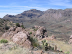
reach the head of the canyon at an ocotillo-blessed pass (20.7,
waypoint 12170, el. 5100'), with commanding views of the rugged
Gila Mountains all around. An abandoned homestead is visible in
the canyon to the north. Our rocky 4WD track now turns west to
another outlook, back toward the sweeping expanse of the Gila
Valley and, closer, the San Juan and Dos Pobres open pit copper
mines now in development. Follow the road northeast, downhill.
Bear right at a fork, then soon right again (21.5, waypoint
12180) (westbounders take the left fork and stay left).
Our road crosses
the wash containing unreliable Bear Spring.
Turn left down the wash a short ways to look for pools in the
bedrock channel. If unsuccessful, turn left again in less than
0.1 mile and walk up a short, narrow side drainage which occasionally
has pools of water near its cliffy head.
The 4WD road
reaches the Old Safford-Morenci Trail west trailhead, with signboard
and trail register, on the left at 21.9 (waypoint 12200,
el. 4700').
|