G.E.T.
Guidebook
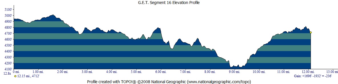
Segment 16: Blue River 12.3
miles  Guidebook
Home Guidebook
Home
Open
this page for printing
Submit
feedback for this segment
|
Segment
Length | Segment
Status | Season |
|
|
|
12.3
mi. | finalized
& accessible | all
year | | Resources |
| OVERVIEW
MAP | 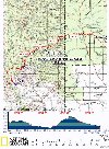 |
| ELEVATION
PROFILE | 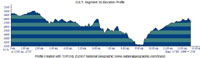 |
G.E.T. Topo Maps 45-46
Water Chart
Image Gallery: Album 5
| Additional
maps:
Apache-Sitgreaves
National Forests (USFS)
Clifton 1:100K Topographic (BLM)
Land management agency:
Apache NF Clifton Ranger District
|
| Beginning
access point | | Ending
access point | |
FR 475 at Pigeon Creek
Trail 465. From
Clifton take US 191 (Coronado Blvd) north ~3.5 mi to the town of Morenci. Continue
on US 191 - a winding, 2-lane mountain highway - north approx. 27 miles (or south
65 miles from Alpine) and turn east onto signed, graded 2WD FR 475 / Juan Miller
Rd. Pass Upper and Lower Juan Miller campgrounds. In ~5 mi from the highway reach
signed "Cow Canyon." A few car camping spots are ahead on the right,
acceptable for parking as well. These spots are just beyond a junction with a
4WD road, signed "Pigeon Creek Trail 465" (also signed FR 475E). Please
note that FR 475 is narrow, with mountain curves and grades, and may be impassable
to passenger cars when wet. | |
FR 475 at Wild Bunch
Trailhead. From
Clifton take US 191 (Coronado Blvd) north ~3.5 mi to the town of Morenci. Continue
on US 191 - a winding, 2-lane mountain highway - north approx. 27 miles (or south
65 miles from Alpine) and turn east onto signed, graded 2WD FR 475 / Juan Miller
Rd. Pass the Beginning Access Point for this segment in 5 miles. Continue straight
at the junction with signed FR 475C, and reach a crossing of the Blue River, ~14
mi. from the highway. The ford often requires a high clearance 4WD vehicle. (A
parking area is on the right, just before the crossing.) FR 475 continues another
2 miles to the signed trailhead for Wild Bunch Trail #7 on the left. Please note
that FR 475, in its entirety, is narrow, with mountain curves and grades, and
may be impassable to passenger cars when wet. | SEGMENT
OVERVIEW From
its source above the Mogollon Rim, the Blue River flows south, first as a creeklet
among fir and aspen, then into the Blue Range Primitive Area as a ponderosa pine-flanked
stream. Descending below the Rim it becomes a small river bordered by shady cottonwoods
and willows. In its lowest reaches along our route in this segment, a vertical
mile below its headwaters, the Blue carves a sheer-sided canyon toward its confluence
with the San Francisco River, whose waters likewise begin in the distant White
Mountains. The San Francisco joins the Gila River below Clifton, and on toward
the Colorado River the fluvial journey unfolds. Toward
the end of this segment the main GET route reaches the canyon of the Blue, fording
the river just once. Because the Blue River drains a large watershed at elevation,
it is prone to significant fluctuations in depth and current depending upon conditions
upstream - e.g., whether or not snow is melting in the high country, or if summer
thunderstorms are hammering just a few or perhaps many of the tributary canyons.
Outside of peak runoff conditions, the Blue is typically ankle to knee deep, 10
to 15 yards wide, and easily forded. Such is certainly the case for both eastbound
and westbound thru-hikers, most of the time. The
main GET route initially follows FR 475 (Juan Miller Rd) from the Pigeon Creek
Trailhead. As roadwalks go, this is a pretty good one, with far-ranging scenery
and interesting geology at roadside. Although the road is graded dirt, the area's
remoteness all but insures only the lightest of vehicle traffic. Nonetheless,
the GET then leaves the vehicle road in favor of a quiet track now gated and off-limits
to the motoring public. This adventurous, unsigned, little-known route - dubbed
Clear Creek Road on some maps, Pat Mesa Trail on others - tours a surprising landscape
of strangely eroded rock formations and viewful mesas en route to the canyon of
Pigeon Creek, which we then follow a short ways to its confluence with the Blue
River and this segment's remote crossing. Another wonderfully obscure track soon
leads away from the river canyon, returning us once more to FR 475 for the final
2 miles to segment's end at the head of the Wildbunch Trail. Thirsty
hikers touring the largely open landscape here will find perennial water at the
Blue River, although seasonal Pigeon Creek is generally a better source when it's
flowing near its confluence with the Blue. Water may also be encountered sporadically
in the drainages crossed by FR 475, most notably at Turkey Creek.
ROUTE
DETAILS From
the junction of FR 475 (Juan Miller Rd) and signed Pigeon Creek Trail 465 (also
signed here as FR 475E) (waypoint 16010, elev. 4950'), proceed east on FR 475.
The somewhat narrow, graded dirt road passes a few impromptu car camping spots
on the right, then climbs out of Cow Canyon's drainage. The springs indicated
on the map, a short ways up Cow Canyon, were not visited, but those in need of
water might try their luck there. Another option, at least in wetter times, is
nearby Pigeon Creek; although normally dry in this area, the wash sometimes flows
by a narrow pour-off ahead. To reach it, leave
FR 475 at 0.4 (waypoint 16020), passing through a fence opening, then angle
southwest down to the drainage and walk down it for a hundred yards or so. (Please
note that the canyon of Pigeon Creek, while becoming an intermittent creek farther
down, nevertheless makes for extremely rough going in its trackless, rocky canyon,
and so does not present the most practical route down to the Blue River.) The
lesser 4WD track of signed FR 8937 heads right (south) at 1.6, beyond which
FR 475 descends around the head of a minor basin to a crossing of Turkey
Creek, at 2.8. The shallow creek, not entirely reliable, is
attractive in its setting of cottonwoods and sycamores. The road leaves the creekside
shade, passing the subdued T Link Ranch on the left, the only private parcel of
land along Juan Miller Road between the highway and Blue River (no camping permitted
in the vicinity of Turkey Creek here). Another undulating traverse leads to the
bedrock drainage of Bear Creek, which occasionally holds water in its potholed
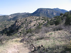
surface (3.5, waypoint 16040). Beyond
another pair of drainages, pass a side road on the right (south) that heads to
a scenic turnout, from which you may appraise the interesting terrain surrounding
Pigeon Creek and its canyon. Especially prominent is the distinctive, flat-topped
and cliff-banded mesa below Pat Mountain. Clear
Creek, signed at
the road crossing at 4.9, may also contain pools or a small flow in wetter
times. Less than 100 yards to the west of (ie, before) the crossing, by
a road sign that reads "Do Not Enter When Flooded," at waypoint 16050,
leave FR 475 / Juan Miller Rd on its south side to join the unsigned Clear Creek
Road (aka Pat Mesa Trail 467). The track had been bermed here, rendering it impassible
to vehicles, but in fall 2009 the road was temporarily re-opened during a work
project on the grazing allotment and is now much more obvious, if still primitive
in character. Reminiscent of the Rug Road over the Galiuros in Segment 6, the
adventurous track heads south, in places over a surface of sculpted bedrock, and
soon reaches a metal gate in a fenceline at waypoint 16060, which was locked.
Climb over the gate, still on public land. After a counter-clockwise bend, watch
carefully for where the track resumes its southward tack in an open area of bedrock
(westbounders, the track turns sharply left here). The
road now climbs to reach something of a pass at 6.1 (waypoint 16070, elev.
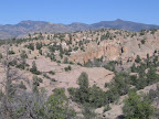
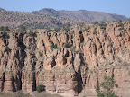
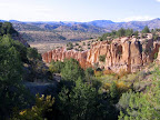
4780'), a commanding viewpoint tentatively dubbed the Clear Creek overlook. The
eastward view encompasses the foreground badland terrain above the drainage of
Clear Creek itself - the light-colored volcanic rock must be a high-silicic welded
tuff or the like - as well as the distant, pointed summits of Maple and Coalson
peaks in Segment 17. Note the intriguing, human-like forms in the prominent canyon
wall just ahead. The descent from the overlook is intially steep and rough. Beyond
a low-point drainage crossing just west of Clear Creek's drainage - which can
be accessed with a short bushwhack - the road ascends more mildly, but also somewhat
vaguely as it seeks out a pleasant southeast contour near the crest of a grassy
mesa-like ridge. Dip briefly to pass through a gate at 7.4 (waypoint 16080),
rounding the fenceline of an old corral, which might allow for camping in any
volcanic cobble-free spots. Continuing
at or near the little mesa's height-of-land, the track eventually descends to
another wire gate (waypoint 16090), here within relatively close range of the
Blue River's canyon, although much of its sheer topography is hidden from view.
(Colorful Johnson Canyon, which our route soon follows, is visible where it cuts
down to the Blue.) Beyond the gate, the road soon turns sharply west, commencing
a slabbing descent into the canyon of Pigeon Creek, now fully in view. Another
gate appears just back from the drainage itself, at 9.0 (waypoint 16100).
Just as the road enters the floodplain, leave it by turning left (southeast) and
walk down the edge of the floodplain, soon reaching a crossing of the main creek
channel, the north wall of the canyon here located just on your left. (Westbounders,
leave the main channel of Pigeon Creek where it bends well away from the sheer
canyon wall on your right, and head up the right-most edge of the open, rocky
floodplain to a crossing of the Clear Creek Road. Turn right on the old road,
which heads north through the gate at 9.0 and climbs out of the drainage.) Continue
to follow the drainage east, crossing Pigeon Creek
wherever convenient. The little creek often flows in this area, nourishing large
Arizona sycamores and other shade trees. Also of note: the seemingly limitless
field of loose, cobbly "river rock" in this portion of the drainage,
which flash floods have obviously carried downstream over the eons, depositing
them wherever the current could no longer support their passage. One fairly rock-free
spot does appear along the south bank, an inviting camp. Negotiate
a somewhat awkward fence spanning Pigeon Creek canyon's width (rather than attempting
to open the tight, bale wire-bound break at mid-fence, try squeezing around the
north or south ends by the canyon walls), then immediately reach the confluence
with the Blue River at 9.4 (waypoint
16105, elev. 4130'). The sudden commotion of the river's 15 yard span is something
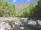
of a primal delight, especially when encountered in such a remote setting as this.
Merriam's turkey are often spotted along the banks in this area, or you may find
their tracks in the soft sand. Ford the river here, typically knee-deep in springtime
- lower in autumn - and proceed north along the grassy bank, where another fine
camp could be made. (Westbounders, continue down the river's eastern shore,
following the open, grassy bank, and note the entrance to Pigeon Creek's canyon
up the opposite bank. Ford the river here.) The
next objective is to locate an old pack trail that heads up alongside the next
side drainage to the north, known locally as Johnson Canyon. Continue along the
river's dry bank, weaving among the open stands of sycamores, cottonwoods, ashes,
and black walnut trees. About 100 feet south of the drainage in Johnson
Canyon, turn right (east), perpendicular to the river, and proceed
70 feet or so to a fenceline gate (waypoint 16110). Here an illegible wooden sign
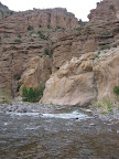
heralds the start of the track, reportedly called the Bohom Trail. The rugged,
all but abandoned track ascends beneath the sheer south wall of Johnson Canyon.
Emerging from the lower canyon, the track splits, with a lesser track that forks
left along a fenceline at 9.8. The main route of the GET follows this fenceline
track to begin an adventurous and wonderfully scenic section of cross-country
travel that also bypasses a private ranch. (Alternatively, you could follow the
increasingly-vague continuation of the Bohom Trail - the right fork at 9.8 - out
to FR 475, but you'll end up walking through the ranch. There's a public easement
along the main road, and the ranch owners are friendly, but you will more than
likely be greeted by an enthusiastic contingent of the family's numerous hound
dogs en route. It's all good, but please make sure to remain on the public road
across this private property.) Following
the fence track at 9.8, a path (or way) down to the drainage of Johnson
Canyon soon presents itself. Cross the pleasant little creek in its
shady, albeit rocky setting, then find a way past a wire fence at the mouth of
a dry feeder canyon that comes in from the north here (waypoint 16116). Now climb
out of the feeder wash on its left side and work your way uphill among the lava
rocks toward an obvious boundary with a different kind of rock just off to the
west - the now-familiar hoodoo-forming "slickrock" tuff. Walk along
this natural geologic boundary (the tuff terain is far easier on the feet) generally
northeastward. A fence opening on the left at waypoint 16117 offers a fun side
trip onto a sprawling bench of eroded rock with great views in all directions.
Eventually our route veers east, following the lay of the land along the edge
of the cliffs, then undulates its way to a meeting with an east-west fenceline.
Keep just south of the fence, using it as a handrail until just before reaching
FR 475, where a minor canyon cuts across your path, recommending a brief detour
south. In any case, now join FR 475 and head north, passing through a gate at
11.0 (waypoint 16125). Continue
easily on FR 475 as it trends northeast among scenic, juniper-dotted grassland,
crosses the drainage of Mud Springs Canyon, then reaches the signed trailhead
for Wildbunch Trail #7 at 12.3 (waypoint 16130, elev. 4700').
|