G.E.T.
Guidebook
Segment 19: Lower Mineral Creek 5.6
miles  Guidebook
Home Guidebook
Home
Open
this page for printing
Submit
feedback for this segment
|
Segment
Length | Segment
Status | Season |
|
|
|
5.6
mi. | finalized
& accessible | all
year | | Resources |
| OVERVIEW
MAP | 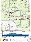 |
| ELEVATION
PROFILE |  |
G.E.T. Topo Maps 49-50
Town Guide: Glenwood / Alma
Water Chart
Image Gallery: Album 6 |
Additional maps:
Gila National Forest
(USFS)
Land management agency:
Gila NF Glenwood Ranger District
|
| Beginning
access point | | Ending
access point | |
US 180 at Alma. Short-term
parking may be available in the village of Alma, located 4.6 miles north of Glenwood
along US 180. Ask at the Alma Trading Company, a convenience store/gas station,
the community's only storefront. (The GET crosses US 180 less than 0.1 mile south
of the store.) Otherwise, consider parking at the Trail 307 Trailhead (the Beginning
Access Point for Segment 18) and hiking segments 18 and 19 together. | |
Mineral Creek Rd at Mineral
Creek trailhead. From
Glenwood, travel north on US 180 ~4.5 mi., then just beyond bridge over Mineral
Creek at Alma turn right onto graded dirt Mineral Creek Rd. In 3.9 mi. from Alma
the road crosses Mineral Creek (usu low water or dry here). Pass Cooney Tomb 1
mile beyond. Continue 0.7 mi farther to one of two parking areas at road's end
near trailhead signboard. The driving route from Alma to Mineral Creek trailhead
follows GET Segment 19 in its entirety. | SEGMENT
OVERVIEW Along
with Segment 18, this short segment offers a convenient link between the backcountry
of Arizona's Blue Range and the Gila Wilderness in New Mexico. US 180 serves as
a natural dividing line between these segments. The 2-lane highway offers access
to the village of Alma, directly
along our route, and also larger Glenwood
a few miles to the south. As
in Segment 18, the route here follows lightly-used roads. In fact this entire
segment is located on graded dirt Mineral Creek Road, providing a straight shot
to trailhead access into Gila country at segment's end. Fittingly enough, the
road runs adjacent to Mineral Creek, flowing seasonally in its lower reaches here
(and perennially in Segment 20 just ahead). Also located along the way is the
historical curiosity known as Cooney's Tomb, a gravesite hollowed out of a large
boulder. Pioneer prospector James Cooney discovered silver and copper along Mineral
Creek and later bragged publicly that he "had not seen a hostile Indian in
this camp for three years," only to be scalped by Apaches two months later.
His friends built the grave, using ore from Cooney's own mine to seal the entrance.
(The so-called Alma Massacre, led by Chiricahua Apache Chief Victorio, ultimately
claimed the lives of several dozen residents of the adjacent community, lending
Cooney's Tomb a somber significance to this day - a small cemetery is located
adjacent to the site.) For
hikers planning to resupply in Glenwood, several options exist to get to (or for
westbounders, from) the start of Segment 20. From Glenwood, you can walk
or hitchhike north on US 180 to Alma and from there hike all of Segment 19, as
described in the Route Details below. Or you can go part of the way to Alma and
then join NM 159 (aka the Bursum Road), reaching the GET at milepoint 1.6 of the
segment, which all told would be about one and a half miles shorter. While in
Glenwood you may also wish to visit the acclaimed Catwalk
National Recreation Trail; however while portions of the Catwalk may be open
and accessible, this trail currently does not offer thru-access to or from the
Gila Wilderness trail network due to heavy damage stemming from the Whitewater-Baldy
Fire and subsequent flooding. GET'ers detouring to the Catwalk from Glenwood are
advised to hitchhike out and back, which usually is not problematic whenever the
Catwalk is open to the public.
ROUTE
DETAILS From
the junction of US 180 and Mineral Creek Road in Alma,
(waypoint 18110, elev. 4900') proceed east on Mineral Creek Rd (C 007 / FR 701).
(At the junction, this road is also signed for Cooney Tomb and Mineral Creek Tr
201.) The quiet, 2WD dirt road passes a few homes among farmland (private lands
at roadside mean no public camping for most of this segment). Keep right at a
turn-off to Alma Cemetery in 0.5 of a mile (waypoint 19010). Now the road
comes close to Mineral Creek, passing Oaks RV Park on the left at about 1.2,
with camping, water and hook-ups for RV's only. At
1.6 (waypoint 19020), signed C 046 (FR 714), on the right offers roadside
access to Mineral Creek, typically ankle-deep
in wetter springs, but dry by autumn. The creekside setting here has changed considerably
as a result of heavy flooding that occurred in September 2013, the channel now
wide and bermed in order to accommodate the threat of similar future floods exacerbated
by the Whitewater-Baldy Fire of 2012. Continuing
on Mineral Creek Road, our route itself eventually crosses the creek
at 3.9, then turns up the other side, now in a shady forested setting,
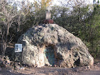
where it enters the private Grove Ranch for a spell. A mile beyond reach Cooney's
Tomb at right (4.9, waypoint 19040), which has been part of the Gila National
Forest only since 2009 (previously the publicy-accessible site was located on
private land). Unfortunately you may encounter concrete barricades in front of
the tomb of late, a measure designed to protect this important cultural resource
from flood damage. In any event, unless otherwise indicated it should still be
possible to explore the area up close, including the small cemetery just behind
it, enclosed by a wrought-iron fence. An
otherwise inviting creeklet that crosses the road near 5.2 actually seems
to have an off-taste, potentially due to historical mining activity upstream.
Thankfully Mineral Creek, even if dry in Segment 19, offers good water and is
perennial just ahead in Segment 20. Continuing on, our road keeps left at a fork,
possibly now signed as Forest Road "4239U," then more or less ends at
a large dirt turnout by an old corral in mature riparian forest. From here a narrow
high-clearance track continues a short distance to the end of Segment 19 by a
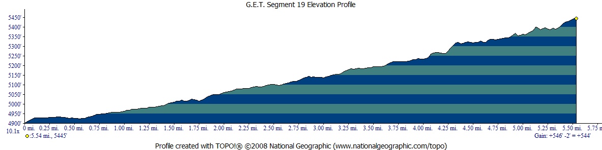
trailhead signboard for Mineral Creek Trail 201 (5.6, waypoint 20010, elev.
5420'). |