G.E.T.
Guidebook
Segment 2: Reavis Canyon 18.0
miles
 Guidebook
Home Guidebook
Home
Open
this page for printing
Submit
feedback for this segment
|
Segment
Length | Segment
Status | Season |
|
|
|
18.0
mi. | finalized
& accessible | fall,
winter, spring | | Resources |
| OVERVIEW
MAP | 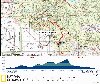 |
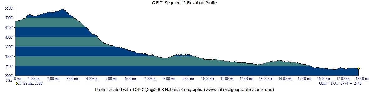
| ELEVATION
PROFILE | 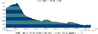 |
G.E.T. Topo Maps 4-6
Town Guide: Superior
Water Chart
Image Gallery: Album 1
| Additional
maps:
Tonto
National Forest (USFS)
Land managing agency:
Tonto N.F. Mesa Ranger District
Tonto
N.F. Globe Ranger District |
| Beginning
access point | | Ending
access point | |
Trail #109 at Forest
Route 172A. Rogers Trough Trailhead is accessible by 2WD high-clearance vehicles
in dry weather, otherwise 4WD required. Two miles east of Florence Junction, turn
north off US 60 onto FR 357, to FR 172, then right on FR 172A. Bear left at jct
with FR 650 and continue short distance to trailhead, appx. 14 mi. from US 60. | |
Picketpost Trailhead
at Forest Route 310.
Picketpost Trailhead is accessible by passenger car. ~4.5 miles west of the town
of Superior, or 0.4 mi east of marked highway milepoint 221, turn south off US
60 onto FR 231. (Formerly obscure, the turnoff has now been signed "Picketpost
Trailhead" by the Forest Service.) Follow dirt FR 231 0.3 mi., passing Picketpost
Windmill, to a junction and turn left, now on FR 310. Take this road 0.7 mi. to
its end at Picketpost Trailhead, with ample parking. | SEGMENT
OVERVIEW Although
not located within officially-designated Wilderness, this segment nonetheless
makes for a scenic, interesting, and remote extension southward from Segment 1
toward the very edge of the Superstition Mountains. Section hikers and very strong
weekend hikers may find it convenient to traverse both of these segments in one
go, rather than accessing either via the remote, rough-access trailhead at Rogers
Trough. Segment 2 begins near the upper elevation threshold of the Sonoran desert,
climbs a bit higher, but soon descends rapidly to the low country, touring among
lush desert foothills and canyons holding seasonal water. Our route here follows
the Arizona National Scenic Trail (AZT) exclusively, most of which is located
on singletrack trail, much of it in good condition yet fairly little-used, although
you may encounter other hikers, mountain bikers and equestrians in the second
half of this segment, especially on weekends.
ROUTE
DETAILS Spring
2018 update: A recent relo of the Arizona Trail off of roads and onto singletrack
trail will replace the first mile of the original description below (shown in
italics), but has not yet been included on the GET Topo Mapset. From the dirt
parking area at Rogers Trough Trailhead, signed Arizona Trail should now exit
the southeast side of the parking lot and climb, via trail, for around a half
mile, where it then joins FR 650 left (southeast), here at mile 1.0 in the description
below (thus the relo is around a half mile shorter than the original route from
Rogers Trough Trailhead, all on roads). From
the dirt parking area at Rogers Trough Trailhead, our GET/AZT route begins by
heading south on FR 172A. Brown, carsonite posts branded with Arizona Trail decals
may appear sporadically at roadside, a common blazing convention along the entire
AZT portion of our route. At 0.3, reach a 3-way road junction and turn
left. (FR 172A continues right here.) Our new road (FR 650) becomes steep and
rough as it climbs, soon reaching good outlooks toward the west. The road then
descends slightly to cross a shallow drainage in lightly forested terrain (mile
1.0), before climbing toward a remarkable outlook, with Weaver's Needle
visible below among the complex ridges of the western Superstitions. Farther left
in the scene, the waters of the distant Gila River often refract the late afternoon
sun. Picketpost Mountain, approached in Segment 3, is visible beyond Montana Mountain,
our near objective. At
2.3 (waypoint 02040), by a cairn, just before a road sign for Trail 509
(facing the other way), our route turns right off the road onto foot trail. This
is Reavis Canyon Trail, which is numbered as Trail 580 on a nearby wooden trail
sign, rather than 509 as elsewhere. The trail traverses uphill toward a saddle
near the top of Montana Mountain (5,557'), then turns east to pass through a gate.
The town of Superior can be seen in the valley of Queen Creek to the south. Picketpost
Mountain and the rugged peaks of the White Canyon Wilderness are also in view,
and beyond them, lone Antelope Peak, which is approached in Segment 5, as well
as the distant Santa Catalina Mountains near Tucson. The
mesquite and grass-lined trail now descends in a long series of switchbacks on
the southern flank of Montana Mountain. The switchbacks number over 30 in total,
and are hard to pick out on the map set, despite what should be an accurate mileage
assessment. Finally, and with potentially sore knees, reach the drainage of Reavis
Trail Canyon at 4.6. The trail meanders back and forth
across the rocky drainage, which may be flowing in springtime or have pools at
other times (especially around 33 22.763 N 111 08.435 W as well
as at Mud Spring: 6.3, waypoint 02070).
Short sections of 2009-constructed trail now keep the trail from following the
drainage itself for any length. The trail contours more decisively away from the
drainage near 7.2, passing through a green metal gate, then continues descending
through the mouth of the canyon, eventually reaching an old stone-wall corral
where a camp could be made. A small dirt trailhead appears not far beyond, where
our trail reaches Whitford Canyon and a 4WD road crossing at 8.0. Arizona
Trail singletrack tread continues across FR 650, first climbing north and east,
then contouring easily southward in and out of saguaro, cholla, and ocotillo-dotted
gullies. Pass through a wire gate at 9.6. The public corral and windmill
visible downhill to the west were rehabilitated in 2011; water may be available
from a pair of cement troughs, and there are
benches and a makeshift table beneath a shade tree, albeit it's a popular spot
for vehicle enthusiasts and so might not lend itself to quiet camping prospects.
To visit the corral, leave the GET / AZT at a 2-track crossing (10.1, 33
20.399 N 111 07.885 W) and follow the road for 0.16 mile. Continuing
on, the trail itself crosses FR 650 again at 11.1, here at a well-signed
junction. Our
singletrack trail now follows near the drainage of Whitford
Canyon, first on its eastern embankment, then through a small but colorful
box canyon section where you may find water in wetter times. Beyond, the trail
proceeds near the wash, crosses it a couple of times, and leaves it briefly near
a rocky bend at about 12.3. Pools of water may persist down in the drainage
near this bend. At
12.9 the GET/AZT crosses a 4WD road and then winds up a low ridge, passing
through a pair of gates in wire fencing near 13.7. Picketpost Mountain
looms ahead as the trail proceeds south along the open, rocky ridgeline, descends
beneath a pair of powerlines, and then reaches a 2-track road at 15.7 (waypoint
02140). Hikers
bound for Superior may prefer to leave the route here (rather than ahead at busy
US 60 where the trail crosses it 4.5 miles west of town) and instead follow the
quiet 2-track road east toward town. (2016 hikers please note: The following
route into town may be closed in part while a Hwy 60 expansion project is ongoing.
Use at your own risk... Keeping right as the road forks, you'll reach a defunct
railroad grade in 0.8 mile. Join it until another dirt road parallels it on the
right. This becomes a gas pipeline utility road, which you'll follow until a gate
near the highway. Pass through the gate and join US 60, following its generally
ample shoulder (or dirt shoulder beyond) about 1.5 miles into Superior. Another
option from the gate at US 60 is to continue into town via the Legends of Superior
Trail, a 2011-completed recreation trail (signed with carsonite posts) designed
to link the Arizona Trail with the Superior area. However, while the Legends Trail,
or LOST trail as it's nicknamed, avoids part of the final 1.5 miles of pavement
walking as described above, the trail is more roundabout and so adds time and
distance to the "commute." The Legends Trail ends on the west at the
Hewitt Station Rd trailhead for the Arizona Trail (see below), offering a modest
shortcut option on the return trip. (Westbound GET'ers could depart for Superior
here and return to the main trail at MP15.7.) From
the 2-track crossing at 15.7 on our route, continue south through a camp-friendly
flat, walking beneath another powerline, then crossing the defunct Magma railroad
line to reach gravel FR 357 (Hewitt Station Rd) near 16.2 at a small trail
parking area. This trailhead also serves as the west terminus of the Legends of
Superior Trail - see the previous paragraph. Beyond, walk through a gate - here
entering a parcel of not-well-signed private land where you shouldn't camp - and
turn sharply right, following beside a fenceline for 0.1 mile. Confront another
gate, exiting private land, just before crossing the wide, sandy wash of Queen
Creek. Look for a cairn or flagging where the trail continues beyond. Pleasant
trail continues in the direction of Picketpost Mountain, crossing beneath US 60
by way of a pair of culverts in a wash at 17.4. Arizona Trail tread resumes
a short ways beyond, ascending a bit to reach FR 310. Picketpost
Windmill, a possible source, is located about 0.9 mile west via FR
310 and FR 231 (or a quarter mile via the wash south of the highway culvert).
Our trail instead crosses FR 310 to reach Picketpost Trailhead, a large dirt parking
lot with vault toilet facilities but no water (18.0, waypoint 03010). (During
business hours, water is available at the Boyce Thompson
Southwestern Arboretum, located on US 60 about 1.5 miles east of the
GET/AZT crossing. US 60 is now a four-lane, high-speed divided highway most of
the way toward the Arboretum, but offers a wide shoulder and should still be open
to pedestrians in this stretch.) |