G.E.T.
Guidebook
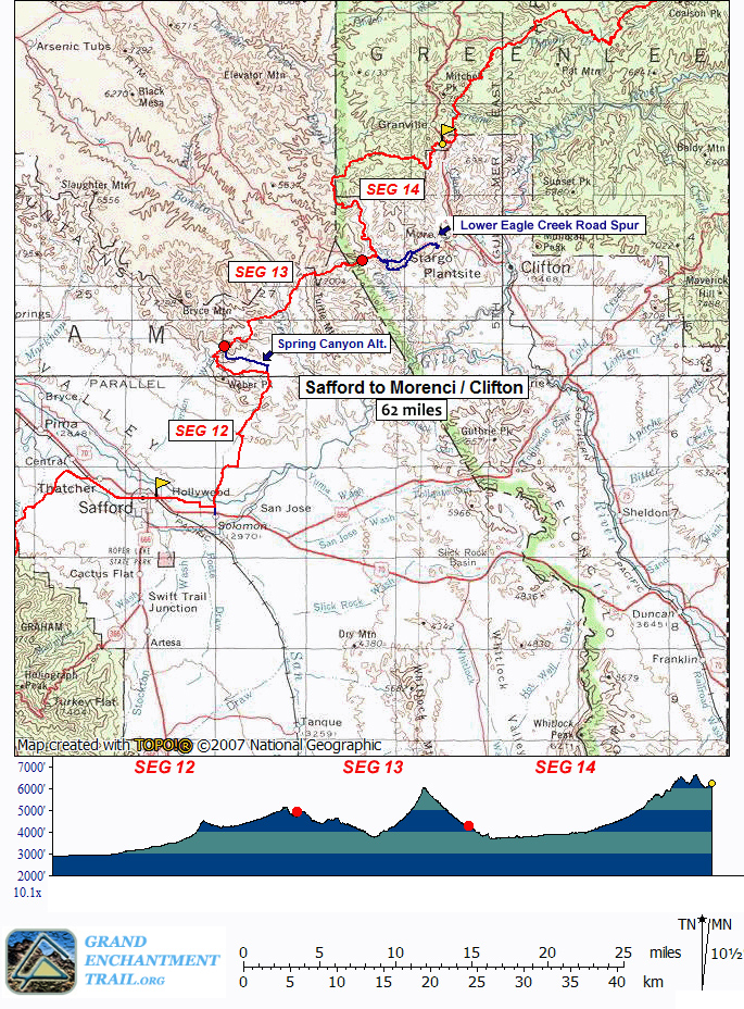
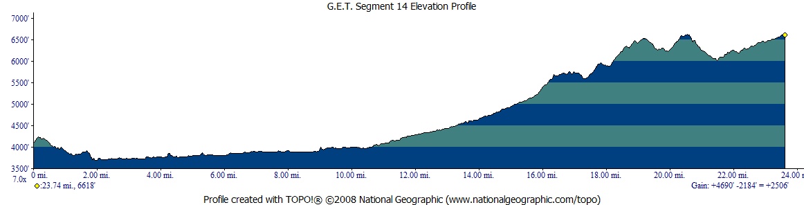
Segment 14: Eagle Creek - Painted Bluffs 23.9
miles  Guidebook
Home Guidebook
Home
Open
this page for printing
Submit
feedback for this segment
|
Segment
Length | Segment
Status | Season |
|
|
|
23.9
mi. | finalized
& accessible | fall
& spring | | Resources |
| OVERVIEW
MAP |  |
| ELEVATION
PROFILE |  |
G.E.T. Topo Maps 40-44
Town Guide: Morenci/Clifton
Water Chart
Image Gallery: Album 4
| Additional
maps:
Clifton 1:100K Topographic (BLM)
Apache-Sitgreaves
National Forests (USFS)
Land management
agency:
BLM Safford Field Office
Apache
NF Clifton Ranger District
|
| Beginning
access point | | Ending
access point | |
Old Safford-Morenci Trail
east trailhead. From
Clifton take US 191 (Coronado Bvd) north to the town of Morenci. Continue another
~5 miles and turn left onto signed, graded dirt Lower Eagle Creek Rd a short ways
before ridge-top overlooks of the mine. The road descends to the flood plain of
Eagle Creek in another 5.5 miles, where it turns left past a pumping facility,
then right to cross the creek. A high-clearance 4WD vehicle is often advisable
here and beyond. Now on unsigned Black River Rd (the same road changes names),
continue ~1.6 miles, along the way ignoring a side road at right, to the signed
Old Safford-Morenci Trail east trailhead. Parking for several vehicles is available
along the roadside opposite and just beyond the trailhead sign. | |
Granville Campground
From Clifton take
US 191 (Coronado Blvd) north ~3.5 mi to the town of Morenci. Continue on US 191,
passing Lower Eagle Creek Rd, the Morenci Mine overlook, and a large turnout on
the right at an unsigned switchback overlook. In another mile pass a second overlook
on the left (Chase Creek Vista). Continue through switchbacks another half mile
to an alternate ending access point on the left at a hiker/equestrian sign
(a 2WD dirt side road leads a short distance to a parking area for Painted Bluff
Trail 13). Another 1.4 mi. on US 191 leads to signed Granville Campground, ~16
mi. from Morenci village. Trailhead parking for several vehicles is past the restrooms
on the left, enclosed by a low stone wall. | SEGMENT
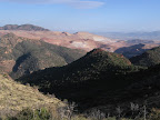
OVERVIEW The
past and present merge with a certain canniness in this segment. Initially the
G.E.T. follows a continuation of the historic trade route which ran from Safford
to Morenci (beyond the current BLM-designated Old Safford-Morenci recreation trail).
We then join the canyon of perennial Eagle Creek en route to the Apache National
Forest. At length we climb away on the rugged Painted Bluff Trail, where ancient
Anasazi pictographs adorn secluded mountain cliffs. Finally our tour tops out
above the modern-day mining colossus of Morenci, affording competing perspectives
of southeastern Arizona's so-called Copper Belt, one toward its natural and prehistoric
wonders, the other its present-day material resources. In
the late 1800's, when the Old Safford-Morenci Trail (Segment 13) was an active
trade route, it reached the boomtowns of Morenci and Clifton via Eagle Creek and
Gold Gulch, following a route which modern roads have since rendered obsolete.
Nor has this portion of the old route been reclaimed as a recreation trail; it
is NOT part of the reconstructed Safford-Morenci Trail, but its history is still
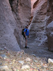
very much alive and on display. A burro trail, pick-axed from the sheer walls
of Gold Gulch, still grants passage around an impressive slot canyon here, and
old metal pitons that once served those ambitious trailbuilders yet remain in
place. Gold Gulch is accessible as part of an alternate route that offers foot
access to the Coronado Trail (US 191) outside Morenci, from which hikers can attempt
a hitch into town in order to resupply (or else continue on to the end of Segment
14 where the main route crosses US 191 and hitchhike from there). This alternate
route option can also be used to bypass most of the 50+ creek fords of Eagle Creek
along the main route, but with the disadvantage of either an extended paved roadwalk
directly past the Morenci Mine, or a hitchhike and missed miles, in order to rejoin
the main route at segment's end. As such, we normally advise against using the
alternate for avoidance's sake except whenever Eagle Creek is in flood. In
the old days, the vast mineral deposits of Morenci spelled paydirt. And for those
who make a living from this remote and rugged country today, the dirt still pays
- big time. Purchased by the Phelps-Dodge Corporation in 1881 (more recently by
Freeport McMoRan) and first developed as an underground copper mine, the lands
around Morenci have continued to yield ore ever since. At a depth of nearly 1000
feet and bredth of several miles, the Morenci mine is now one of the largest open-pit
mines in the world and is North America's largest producer of copper cathode,
the stuff that keeps us "wired" in our modern, high-tech world. A side trip to
Morenci village winds past the mine, within plain sight of its towering equipment
and massive haul trucks, all the while telling the story of a land whose many
and varied chapters are little-read by the outside world. Morenci
village and its sister town of Clifton are potential resupply points for thru
travelers. Clifton is a virtual living history museum to the old mining days before
Morenci stole the reigns. In fact, the celebrated Apache Geronimo was also born
nearby, and Chase Creek Street in town still looks much the same as in the days
when saloons and brothels lined its now-quiet flanks. Hikers
following the main route in this segment generally enjoy a leisurely pace along
Eagle Creek, sloshing back and forth across the drainage as dictated by the terrain,
and pausing among leafy shade trees to admire the surrounding cliffs. The upper
reaches of the canyon can be a little more challenging, with a somewhat deeper
channel and the occasional beaver dam-flooded area. The Painted Bluff Trail is
likewise rather primitive in character, is quite remote in its lower reaches,
and ultimately provides a scenic and rewarding trip out to US 191 at segment's
end.
ROUTE
DETAILS From
the Old Safford-Morenci Trail east trailhead (waypoint 13250, el. 4100'), turn
right onto Black River Road. The rough, graded dirt road ascends among mesquite
and juniper to pass an old corral. At 0.6 of a mile, ignore a well-worn
2-track road on the left (the 2-track leads to a flat, relatively camp-friendly
spot by a usually dry stock pond within 500 feet). Continue to a junction at 1.0,
where the main GET route turns sharp left onto a road flanked by a pair of tan
metal posts. (Or continue straight at the junction on Black River Rd to follow
the Lower Eagle Creek Road Spur, a roadwalk route which leads 6 miles -
first down to a single ford of Eagle Creek, then uphill all the way - to US 191,
where one can attempt to hitchhike into Morenci or Clifton to resupply. See the
description of this alternate route at the end of this chapter.) The
main GET route soon reaches a Y-intersection, taking the left fork. In 0.1 ignore
a road on the right that heads out to a point above an old reservoir in the canyon
of Eagle Creek. In another 0.1, turn left (west) at a t-junction, and follow the
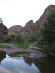
road somewhat uphill, then down to reach a first crossing of Eagle
Creek in its scenic cliff-bound canyon at 2.0 (waypoint 14130,
elev. 3690'). Typically ankle-to-shin deep here in its lower reaches, and 10-15
yards wide, perennial Eagle Creek is forded about 50 times in the 9 or so miles
the GET follows it. The channel gradually narrows up-canyon, and in a few spots
may be thigh-deep during average flow periods, especially in the final two miles.
The current is typically reduced at the deeper crossings. Be sure to treat the
creek water before drinking, particularly due to likely cattle activity upstream. Ford
the creek, passing beneath an old tram car line that must have served the former
reservoir downstream. (Westbounders, ford the creek beneath the tram and join
the road that heads right from the opposite bank, soon leaving the drainage.)
A cobbly 2-track parallels the creek upstream, which we follow, here passing
the remains of a gaging station. The
willow-lined creek soon turns north, the track fording it at frequent intervals.
At 2.5 a spur track on the west bank accesses a potential camping spot
among shady sycamores and mesquite trees. (The site is likely popular with fishermen
as well; all of Eagle Creek in this area is owned by the Phelps-Dodge Corporation
[now Freeport McMoRan, Inc], which thankfully allows public use of the resource.)
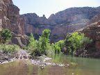
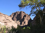
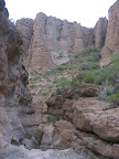
The tan and buff
conglomerate cliffs on the east wall of the canyon are impressive near the confluence
with Horseshoe Canyon, where the creek bends west. Probably the most spectacular
part of Eagle Creek Canyon occurs near 4.4, where another, unnamed drainage
cuts deeply down to the main canyon. A scenic camp could be made at 5.2
(waypoint 14150), a smooth, grassy spot with campfire ring on the east side of
the creek, a short ways after the track fords to this side. The
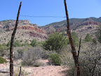
red, iron-rich volcanic exposures of Coronado Ridge soon come into view off to
the north, while our canyon now widens a bit, offering the option to follow the
2-track road or impromptu horse/cow paths that leave and rejoin the 2-track at
intervals. The meandering paths are often easier on the feet than the rocky, creekside
track. At 7.1 another potential camp appears, above the cobbles on the
north bank, among some shady walnut trees. With
perhaps 38 of 50 fords now behind you, the 2-track comes to a gate in a fenceline
at 8.3. Pass through the gate, which is unlocked and unposted, and turn
right, circumventing an old ranch house, the bulk of which is posted private
property. Primary vehicle access to the lonely dwelling must be via the adjacent
San Carlos Reservation, rather than up the creek. The
obvious way north up the canyon keeps to the west bank initially, passing a tree
with a rope-swing. (Westbounders - heading south - should be on the west bank
approaching the homestead, as a fenceline spans the drainage ahead.) Soon
pick up a de-facto pack trail, which, like the 2-track, follows along the banks
and occasionally fords. (OHV's occasionally widen the first part of the trail
between flooding episodes.) Seemingly well-trod by horses, the pack trail attempts
to stay back from the creek corridor as much as possible, thereby avoiding the
densest riparian vegetation. The trail occasionally branches and can take some
finding again after it fords, though pruned tree limbs here and there offer reassurance.
Wildlife is abundant in this more pristine portion of the canyon; watch especially
for raccoons and coatimundi along the cottonwood and sycamore-lined creek. The
final mile along the creek is somewhat rough and slow-going, with deeper fords
and occasional deadfall tangles at creekside due to flash flooding. Beyond the
side drainage of Pistol Creek (shown on the map), the pack trail generally sticks
to the east bank of Eagle Creek. Keep to this side of the creek as the canyon
bends southeast. Here the trail emerges from the trees onto the open flood plain,
follows its southern edge, then skirts back into the bordering woods on your right
for a short ways, before ending for good at a cairn. Note the prominent red cliff
straight ahead, an obvious landmark, on the south side of the creek where it bends
north upstream. Continue in the open portion of the flood plain a little farther,
then bushwhack to the creek, fording it just before this bend. The canyon now
resumes a northward tack. Soon ford again to the east bank at the confluence with
Knight Canyon, at 10.8 (waypoint 14180, elev. 4015'). The confluence is
somewhat inconspicuous, as Knight Canyon is willow-lined and often sediment-laden
here, although flagging tape and/or a cairn sometimes mark the turn-off. (Westbounders,
emerging from Knight Canyon, ford Eagle Creek
here, then walk down the opposite bank and ford back across just beyond the bend,
where the creek turns northwest. Find a way through the riparian growth, then
back in the open turn northwest. Look for a cairn on your left indicating where
pack trail heads into some woods at the base of the cliff there.) Now
in the Apache National Forest, proceed cross-country up the rocky drainage of
Knight Canyon, passing through a gate at 11.2. As the canyon turns north,
look carefully for a pack trail on the left (west) bank, which immediately climbs
away (waypoint 14192). This, in essence, is the westernmost end of the Painted
Bluff Trail #13, which you'll follow east all the way to the Coronado Trail (US
191) near segment's end. (If you reach an area in the drainage with huge, obstructing
boulders, then you missed the trail turnoff.) Primitive and brushy, Trail 13 contours
above the drainage, surveying some intriguing eroded cliffs, and soon reaches
the hardscrabble remains of Lower Cottonwood Corral (waypoint 14194), which it
passes directly through. The trail then returns to the canyon floor at an area
of possible spring pools in the bedrock, at
11.7 (waypoint 14200), often a fine source (scout down-canyon a short ways
if the first area of pools is dry). Immediately the trail climbs away again, via
the same side of the canyon. The
trail now develops a habit of crossing the main drainage back and forth, though
the crossing points are often vague and the trail hard to pick up again on the
opposite side. Look for possible flagging, and note that the trail rarely follows
the rocky drainage itself for very long, but prefers to cross it directly, then
parallel it farther up in the flood plain where the going is less rough. The trail
crosses to the left (west) bank at 33 08.956 109 28.806, where it remains
until reaching Cottonwood Corral
at 12.5 (waypoint 14210). Now defunct, the old corral would make for a
flat and smooth campsite, with spotty live oak shade and some intriguing rock
formations adorning nearby ridges. Spring pools
are occasionally found in a sculpted bedrock portion of the adjacent drainage
less than 100 yards southwest of the corral, though this source is often dry. Beyond
the corral the trail continues to another crossing of the drainage, marked by
cairns. Most of the crossings beyond are also now marked by cairns, some more
obviously than others. Approaching 12.9 the trail returns to the drainage
and remains in it as our route turns north, (waypoint 14220) trading Knight Canyon
for an unnamed canyon that nevertheless is the more prominent of the two. Look
for the resumption of trail tread in a short ways. (Westbounders, upon joining
Knight Canyon, watch for the trail leaving the rocky drainage course on the left,
where it remains until crossing back to the other side soon before reaching Cottonwood
Corral.) A
trail sign heralds your arrival at Cottonwood Spring environs. Nailed to a sycamore,
the sign seems out-of-place in this secluded area, with "Hwy 666" (now
US 191) shown as 9 miles away (likely closer to 8) and Eagle Creek 4 miles back
(more like 3 and change). Cottonwood Spring
(14.1, waypoint 14230) typically flows in the drainage for a couple hundred
yards, occasional cattails and watercress assuring that it is a reliable source.
Be sure to fill your bottles here, as the next fairly dependable water is nearly
12 uphill miles away at Frye Spring (or seasonally at Granville Campground). (Side
note: just west of the aforementioned trail sign, what appears to be an unmarked
trail climbs away on the north side of the drainage. In fact, this is nothing
but a well-worn stock path, not the Painted Bluff Trail which instead remains
in the drainage. Westbounders, be careful not to go this way by accident when
leaving Cottonwood Spring, as the errant path goes nowhere after the initial steep
climb.) Now
better defined by cairns, the Painted Bluff Trail continues to shortcut the drainage's
meandering course, crossing it at frequent intervals, while rolling hillsides
of scattered mesquite cast a decidedly arid air. At times the trail climbs a fair
height above the drainage in order to shortcut bends in the channel. Finally the
trail crosses to the north bank one last time, turns right alongside it, and climbs
a short ways to reach a corral at 15.9 (waypoint 14240), leaving the drainage
for good. Pass through the corral and turn right beyond it. (Westbounders continue
through the corral and turn right, soon descending to cross the drainage at a
cairn.) Old
cattle paths may briefly confuse the way ahead, where our trail soon angles somewhat
northeast, then climbs east to a level height-of-land. From here to Wood Canyon
the trail contours along south-facing slopes, with occasional short climbs and
descents. A cement trough on the left (at waypoint 14245) is fed by Pinto
Spring about 300 feet up the slope above, but the pipe is disabled
and the trough dry. Following the pipe will lead to the spring, which collects
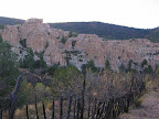
in another cement trough at the base of a cliff. Also
above the cement trough at trailside, an Anasazi rock art site is located among
the colorful cliff exposures of the Painted Bluffs. Situated at the base of the
main cliff band, perhaps 300 vertical feet above the trail, just to the left of
the steep little canyon that divides the cliffs (Pinto Spring is to the right,
lower), the site contains some of the best preserved pictographs (cliff paintings)
in the Southwest, due in no small part to its rugged isolation. Other surprises
also await discovery here; by all means, plan to allot some extra time to explore
the area, but consider leaving your GPS unit off here, and allow the next explorer
to enjoy the same rewards in finding the site as you experienced. The
trail commences a final descent into Wood Canyon, crossing the rocky, usually
dry drainage at 17.6. Just before the crossing, a rough little side trail
on the right (heading south) leads less than 0.1 mi. to a primitive campsite in
a secluded setting among Arizona cypress. Just by the camp is Curve
Spring, an unreliable pool (or series of pools) in a bedrock portion
of the wash (waypoint 14250). At last check, though, the side trail was so overgrown
as to be more or less impassable. The best way to the spring may be to just head
down the drainage itself. The
trail turns left up the east bank of the drainage, then heads right to climb away
on more prominent tread. (Westbounders, the trail turns left as it approaches
the drainage, heading south along the bank for a ways, then crosses the wash.)
Back in more open terrain, pass a cleared area on the right in 0.1, which could
fit a tent or tarp. The trail corridor remains in generally passable condition,
with occasional large cairns offering reassurance. Dip awkwardly into a minor
drainage, then climb away toward the east, reaching a gate at 18.7 (waypoint
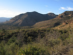
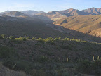
14260). Commanding views open back down the broad expanse of Wood Canyon toward
distant peaks beyond Eagle Creek. The
trail now slabs across the rocky slope as it ascends southeast, traversing among
pinyon pines and Arizona cypress trees, the latter of which appear to be faring
rather poorly in this area, perhaps due to climate change and/or the proximity
to the Morenci mine. (Elsewhere in the region they appear to be thriving, as obviously
they once did here, given the density of the stands.) Arrive at a prominent saddle
at 18.6 (waypoint 14270, elev. 6480'). A small, somewhat sloped
campsite with fire ring is here, nestled among the conifers. Here the Morenci
mine comes into view off to the east, presenting a sudden, striking contrast to
the landscape behind you. The open-pit copper mine's orange tailings walls are
enormous, a fact which only hints at the collosal scale of the ongoing excavation.
Massive haul trucks plumb the depths day and night, yet from this vantage appear
as mere toys. From
the saddle the trail heads northeast in the company of scrub oak and our now-familiar
Arizona cypress. Occasional blowdowns in this stretch will continue to be the
norm as long as the standing dead timber remains. As of 2013 a route had been
hacked by ax through the worst tangle, resulting in a somewhat awkward but at
least passable detour. Beyond here the trail reaches a level, airy perch at 19.9,
where an old wooden plank supported by rocks serves as a bench, inviting pause.
The area has been laboriously cleared of debris and would make for a viewful,
if dry, camp. The
overgrown limbs of scrub oak and mountain mahogany once made for a scratchy walk,
but the trail now remains good en route to a drainage crossing at 20.3 (waypoint
14290). After ascending a small rise by a dry stock impoundment, singletrack trail
ends and Painted Bluff Trail 13 continues to the trailhead as an old 2-track road.
The 2-track climbs north,
then trends east in open, grassy terrain. Continue straight at 20.7, where
an eroded track climbs away at left. The mine is once again in view, though soon
enough will become a distant memory (except, that is, for those planning to resupply
in Morenci, whose highway detour visits the open pit at close range). Descending
a small red-clay knoll, the old 4WD turns left, soon contouring east, then turning
north again to descend toward a crossing of the canyon's main drainage. Here our
road bends southeast, passing some shady live oaks at left - a nice lunch spot.
Ignore a side road that joins from the north and continue climbing southeast on
the main 4WD. (Westbounders stay left, descending.) Painted Bluff Trail
13 ends in less than half a mile at 22.2 (waypoint 14320, elev. 6250')
by a large dirt parking area off of US 191. (Westbounders, look for a cairned
metal sign at the northwest end of the lot. Just beyond it, a wooden signpost
for the Painted Bluff Trail indicates which 2-track road to take here.) From
the trailhead, the GET follows the dirt access road north to a junction with US
Highway 191 by a hairpin turn at 22.3. This curving mountain biway is known
as the Coronado Trail, as it roughly follows the historic route of Francisco Vasquez
de Coronado's expedition in search of the fabled Cities of Gold. (Those intending
to hitch into Morenci or Clifton to resupply should plan to be patient waiting
for a ride, especially weekdays and mornings. One way to improve the odds is by
first following the low-speed, 2-lane road south a bit under 2 miles to a scenic
roadside overlook for vehicles, which sees some turnaround traffic coming up from
Morenci, in addition to tourists heading south toward town. All southbound traffic
heads at least as far as Morenci. Along the way to the overlook, you'll pass signed
Chase Creek Scenic Vista at 0.6 - a worthwhile stop. An interpretive sign points
out several area peaks, as well as a small natural arch below, alongside the serpentine
highway. Portions of the Morenci mine are also visible. In any case, it seems
few vehicles stop here, preferring the more obvious turnout located about a mile
farther down the highway, the recommended hitchhiking spot. Note that locals actually
seem to refer to this lower turnout as the Chase Creek Scenic Vista, rather than
the upper one, a worthwhile consideration if calling for a ride.) From
22.3 the GET follows the highway north, immediately entering the Apache
National Forest. After a few curves the road straightens out above the drainage
of Chase Creek, trading southerly views for a secluded forested setting. Pass
a highway sign for southbound vehicles listing "Morenci 16 miles," and
offering another potential hitchhiking spot (maybe try pointing at the sign with
a trekking pole whenever a vehicle happens past, in order to indicate your destination
to unfamiliar tourists). At 23.7, turn right onto Granville Circle at the
signed entrance to Granville Campground. The dirt road crosses a cattle guard,
passing through a pleasant forest of gamble oak, maple, and occasional ponderosa
pine - excellent habitat for stellar and scrub jays, as well as the distinctive
acorn woodpecker - before entering the campground proper. Vault toilet facilities
(with trash cans), as well as combination picnic / camping sites are here (free,
first-come first-served, generally a quiet place), in addition to several water
spigots which are turned on usually from April to October. (The rest
of the year you might find water at the north end of the campground, by a private
cabin. See the beginning of chapter 15 as well as the water chart for details.)
Segment 14 ends at 23.9 (waypoint 15010) by a parking area just north of
the restrooms, enclosed by a low stone wall, in essence the trailhead for the
Granville and Pinal trails accessed in Segment 15.
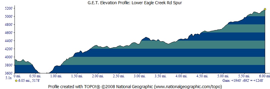
ALTERNATE ROUTE: LOWER
EAGLE CREEK ROAD SPUR
| ELEVATION
PROFILE |  |
This alternate route
is intended as a way to reach US Hwy 191 in order to hitchhike into Morenci and
Clifton to resupply, rather than by hitchhiking from the end of the segment. Although
it's a 6 mile hike out to the highway via this alternate (as opposed to less or
no off-route hiking from segment's end) the hitchhiking prospects are arguably
better via the alternate due to the proximity to the Morenci mine and related
traffic. The Lower Eagle Creek Road Spur can also be used to bypass Eagle Creek
during times of high water. One ford of the creek is still required, but would
only very rarely prove unmanageable on foot. In general, this alternate route
is not intended to serve as a way to walk either all the way into Morenci or around
the main route in Segment 14 altogether, since either would involve a protracted
roadwalk on US 191, which features a narrow shoulder, hairpin turns, and for the
most part an industrial air as it tours past (in essence, directly through)
the Morenci mine. Current
streamflow data for Eagle Creek is available from the USGS here.
The data is recorded not far above the alternate route's single ford. Suffice
it to say, readings in the near-normal to somewhat-elevated range for any given
date should allow for safe crossing. From
the road junction at 1.0 of the main route, (0.0 of the alternate) keep
right (east) on Black River Rd. Soon descend rather steeply into the scenic gorge
of Eagle Creek, passing a ranch on the right just before the dirt road fords the
creek, at 0.6 (waypoint 14020, elev. 3600'). Eagle
Creek is typically
10 yards wide and ankle-to-calf-deep here. Despite the pumping plant just upstream,
and almost certain cattle activity, the perennial water seems to be as suitable
for drinking (with treatment) as other creeks its size along the route. Just beyond
the creek, the primary alternate route turns left along the road (now called Lower
Eagle Creek Rd), while the Gold Gulch alternate heads right, an interesting
detour that meets up with the Lower Eagle Creek Road Spur again in a few miles.
(Refer to the GET topo map set, and see below.) Use the Lower Eagle Creek Road
Spur in order to avoid further fords of Eagle Creek, or in times of high runoff
or imminent flash flooding, when the otherwise intriguing slot in Gold Gulch would
be dangerous to enter. The Lower Eagle Creek Road Spur follows Lower Eagle Creek
Rd past the pump house, then turns right and switchbacks uphill, soon passing
the curious ruins of a Spanish missionary-style church. The road finally tops
out on a scenic ridge above the gorge, and continues east to cross the shallow
drainage of upper Gold Gulch, where the Gold Gulch alternate rejoins (waypoint
14070). Distances are similar along either route. Gold
Gulch alternate From
milepoint 0.6 of the Lower Eagle Creek Road Spur , on the east bank of
Eagle Creek, the Gold Gulch alternate heads right (south). Follow the rough
jeep track, which soon dabbles with the creek again. The canyon, with its richly
hued, eroded cliffs and pinnacles rising 1000 feet above the tall creekside greenery,
is truly a feast for the senses. Eagle Creek here is privately owned by the Phelps
Dodge Corporation (now Freeport McMoRan, Inc), which nonetheless allows recreational
use of the canyon, including camping. The jeep track fords the creek here and
there; some of the fords may be deeper (but with gentler current) than others.
Pass some potential campsites on the right (west) bank, not long before the side
canyon of Gold Gulch enters on the left, at 1.5 (waypoint 14040). The
entrance to Gold Gulch is fairly obvious - the first prominent side canyon, with
a deep floor and small grove of cottonwoods near its mouth. Turn left onto a cobbly
side track to ford Eagle Creek again, then enter the narrow gulch. (Or, to visit
the hot spring shown on USGS maps, it appears that one would continue another
half mile down Eagle Creek.) The dry creek bed of Gold Gulch soon narrows to a
beautifully sculpted slot canyon, which is navigable for about 200 feet, where
an impassable pour-off may nonetheless delight with a thin rivulet
of fine-tasting water. Curiosity
quenched, backtrack out of the slot, and look carefully for an old trail that
leaves the wash on its south bank. The trail heads up-canyon, paralleling the
drainage while ascending slightly along the base of a cliff, past a grove of mesquite,
and soon reaching a switchback. At the switchback it should be possible to clamber
up the low-angle cliff to a rejoining of the trail above - an option if the trail's
modest exposure seems problematic. Otherwise, follow the trail - a narrow side-cut
notch in the cliff face - as it climbs through another switchback. This trail
was apparently built in the early days of the Safford-to-Morenci trade route;
the occasional pitons below the trail aren't of any use now. Beyond the bare rock,
the trail contours along a brushy bench, remaining close by the south wall of
the canyon. Follow the bench to its intersection with the main wash of Gold Gulch,
just above another impassable pour-off. (Westbounders, upon reaching this pour-off,
veer left around it onto the bench, keep the cliff wall close on your left and
continue until it seems you cannot proceed further. Here look for the notched
trail in a low-angle cliff, with conspicuous bolts.) Eastbound,
Gold Gulch continues as a non-technical slot, although you may need to remove
your pack in a couple of spots in order to hoist yourself unencumbered over small
pour-offs. It's hard to imagine how pack animals would have ever negotiated these
narrow, serpentine canyon walls. In dry weather only, secluded camping may be
possible where the canyon widens into a box, especially inviting when the slot
below happens to contain pools of water. Proceed
widely around a final pour-off by following the brushy slope on its left side.
The slot/box portion of the drainage ends here, at 2.0 (waypoint 14050) Walk
up the wide wash of Gold Gulch, negotiating a couple of fencelines, to reach a
4WD crossing at 2.9 (waypoint 14060). A corral and unreliable stock pond
are on the left. Continue cross-country up the wash, at 3.6 passing beneath
a trestle-supported water pipeline serving the Morenci mine. Bighorn sheep are
often seen grazing near this pipeline, especially where it first climbs from Eagle
Creek farther to the west. The wash reaches graded, 2WD Lower Eagle Creek Rd.
Turn right on the road, here rejoining the primary alternate route eastbound (waypoint
14070). Continue
east on Lower Eagle Creek Rd. The vivid orange tailings of the Morenci open pit
loom dead ahead. (Westbounders, turn left off the road to follow the Gold
Gulch alternate down the wash of Gold Gulch, or remain on the road to keep
to the Lower Eagle Creek Road Spur .) Lower
Eagle Creek Rd curves and climbs, passing a ranch on the right, then ends at an
intersection with paved, 2-lane US 191 at 6.1 (waypoint 14080, elev. 5200').
This curving mountain highway is known as the Coronado Trail, as it roughly follows
the historic route of Francisco Vasquez de Coronado's expedition in search of
the fabled Cities of Gold. Traffic is generally light, and the highway is low-speed,
but the road is narrow and with only a minimal shoulder in places. Hitchhike into
Morenci from here, or around the road bend just to the south (or call a town business
such as the motel to see if anyone might offer a ride). Walk the final 5 miles
into town only as a last resort. Side
Route to Morenci & Clifton US
191 heads south, then curves east by a storage yard, where you may witness some
of the goliath mining equipment up close. An historic Catholic cemetery - of all
things - is nearby on the left, now all that remains of the town of Old Morenci,
long since consumed by the ever-expanding mine (and reincarnated as the present-day
village of Morenci, ahead). The highway loses elevation through a series of dramatic
hairpin turns, affording revealing views north into one of the mine's main ore
pits. The road enters a 60 yard-long tunnel, which grants semi-safe passage via
a pedestrian walkway. Beyond, a huge conveyor overhead delivers quarried material
to a sorting facility. Use caution when entering the short underpass ahead - eastbounders
must walk along the left shoulder to avoid a blind curve on the right. (Westbounders,
approach the underpass by walking behind a guardrail on the left side of the road,
then cross the road to enter the underpass on the right side.) Reach
a traffic light by the main entrance to Freeport-McMoRan Inc., where the mine's
low-grade ores are processed into pure copper cathode (via a supposedly enviro-friendly
leaching process), then shipped by train to smelting facilities outside the area.
Continue south on US 191 about 1.4 miles to Morenci
village. The village plaza, with post office, bank, restaurants, supermarket,
and nearby Morenci Motel, is on the right. (To visit Clifton
and historic Chase Creek Street, you can remain on now-busy US 191 for 3 more
miles, or follow an old railroad grade - quiet but longer - as shown on the map
set.)

|