G.E.T.
Guidebook
Segment 21: West Fork Gila River 17.2
miles  Guidebook
Home Guidebook
Home
Open
this page for printing
Submit
feedback for this segment
|
Segment
Length | Segment
Status | Season |
|
|
|
17.2
mi. | finalized
& accessible | spring,
summer, fall | | Resources |
| OVERVIEW
MAP | 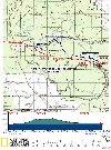 |
| ELEVATION
PROFILE | 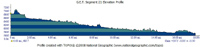 |
G.E.T. Topo Maps 57-60
Water Chart
Image Gallery: Album 6 |
Additional maps: Gila
National Forest (USFS)
Gila Wilderness (USFS)
Land management agencies:
Gila
NF Wilderness Ranger District
|
| Beginning
access point | | Ending
access point | |
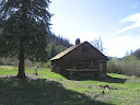
Trail 151 at White Creek
Administrative Site. This
segment begins within the Gila Wilderness, at a remote location accessible only
on foot or horseback. For the nearest vehicle access to the east, see the Ending
Access Point for this segment, at right. | |
NM 15 at Gila Cliff Dwellings
contact station. From
Silver City NM, follow NM 15 north (narrow and winding, with some steep grades*)
43 miles to t-junction and turn left, remaining on NM 15. Parking is available
at TJ Corral trailhead on the right in 0.8 mi. (access to Seg 21 Highwater Bypass
trail network). Otherwise continue additional 0.8 mi to Gila Cliff Dwellings contact
station and parking for West Fork.
*Those
wishing to avoid mountainous portions of NM 15 can instead use NM 35: turn north
onto Highway 152 from Highway 180 at Santa Clara, NM. Follow 152 to the junction
with 35 and follow 35 to the junction w/15. | PLEASE
NOTE: THIS CHAPTER REMAINS UNFINISHED. SEGMENT OVERVIEW AND ROUTE DETAILS INFO
BELOW ARE IN DRAFT FORM AND HIGHLIGHT ONLY THE ESSENTIALS NEEDED FOR NAVIGATING
THIS SEGMENT IN CONJUNCTION WITH THE TOPO MAP SET. SEGMENT
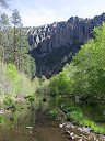
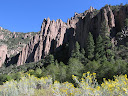
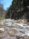
OVERVIEW Main
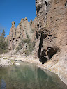
route follows sheer, serpentine, pinnacled canyon of W Fork Gila River for 15+
miles, with option to visit Gila Cliff Dwellings beyond or follow singletrack
trail above river to TJ Corral trailhead. 60+ fords of river en route, knee-thigh
deep in wet spring, or ankle-shin deep in fall or dry spring. Current not usu.
major concern, but some of the earlier fords (eastbound) can be a bit slippery
underfoot. Water can be quite cold during snowmelt or in late fall. Navigation
straightforward; trail fords, then heads back into bordering riparian woods, sometimes
vague or washed out following floods. Highwater
Bypass route avoids all but one ford of W Fork Gila River at White Creek Admin
Site, not usually problematic. Route is leisurely on mesas, in open pine forest
with limited views, but quite dry with only occasional water in area tanks/ponds
some distance off trail. Feeder trails off Bypass route connect with main route;
one heads up from Hell Hole area, intended for eastbounders who've lost interest
in fording (only 6 more fords en route vs the one required ford when following
Highwater Bypass in full, so a good option whenever the river is somewhat high
/ swift but not dangerously so), or westbounders in need of water at river. Other
feeder uses CDTS route, mainly for westbounders, or eastbounders planning to visit
the Cliff Dwellings; involves several river fords for westbounders before joining.
ROUTE
DETAILS To
follow Highwater Bypass involves one ford of W Fork Gila
River from White Creek Admin Site (Bypass begins at end of Seg 20). Main
GET follows Tr 151 south from White Creek Admin Site passes meadowy camp sites,
then fords river to meet junction. Bear left at sign (right is former route along
river in this area, now abandoned). After well-graded climb to a bench, gradual
descent back to river at 1.8. Now begins routine fording at intervals,
however still intermittent all the way to the Hell Hole area, with predominantly
forested walking on benches either side of creek. (Westbounders ignore side
trail marked "Dead End" on your left just before 1.9.) Bear right
at signed jct at 3.7, or left to join Bypass route. Good camp
just before 4.3. (Westbounders bear left, remaining on Tr
151.) Camping and water never far away continuing eastbound, with frequent
fords in this most dramatic section of the canyon (50 or so fords between MP 4.3
and 15.1). The mapset highlights some of the better camping locations, all of
which are dry, level, and amply forested, albeit many of them aren't established
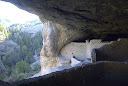
camps per se but simply favorable areas. Cliff
dwelling (waypoint 21090) on eastbounder's right, south side of canyon, heavily
weathered, not part of GCD National Monument proper. Might be approachable with
care via rough use trail. CDTS
route (northbound) at 15.1, (after several fords for westbounders);
connects with Highwater Bypass following prolonged, fairly shadeless ascent out
of canyon. Occasional camps between here and 16.6 on main route; trail (and river!)
in this area occasionally relocated in places due to flooding. At
16.6, Trail 792 continues in canyon bottom to trailhead at segment's
end (17.2, waypoint 21130) (previously without fords en route but at last
check requiring two due to flood plain changes) and access to Gila Cliff Dwelling
National Monument. Developed water and toilet at GCD contact station. Dwellings
accessible via short paved loop trail during Nat Mon daily operating hours only
(generally until 4:30 or 5pm). First time visitors should plan not to miss this
side trip. Otherwise, since the start of Segment 22 beyond requires a stretch
of paved roadwalking, another option from 16.6 is to continue via Trail 151, contouring
along scenic grassy hillsides and side canyons above the W Fork drainage to TJ
Corral trailhead, here rejoining the main route at MP 0.8 of Segment 22.
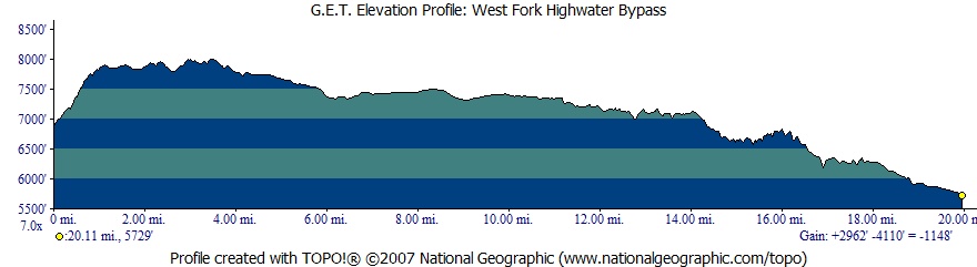
ELEVATION
PROFILE:
WEST FORK HIGHWATER BYPASS | 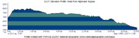 |
|