G.E.T.
Guidebook
Segment
5: Antelope Peak 16.3 miles
 Guidebook
Home Guidebook
Home
Open
this page for printing
Submit
feedback for this segment
|
Segment
Length | Segment
Status | Season |
|
|
|
16.3
mi. | finalized
& accessible | fall,
winter, spring | | Resources |
| OVERVIEW
MAP | 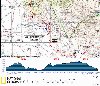 |
| ELEVATION
PROFILE | 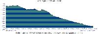 |
G.E.T. Topo Maps 12-14
Town Guide: Mammoth
Water Chart
Image Gallery: Album 2
| Additional
maps:
Mammoth 1:100K (BLM)
Trail managing agency:
Arizona Trail Association |
| Beginning
access point | | Ending
access point | |
Arizona Trail at Freeman
Road. From AZ 77
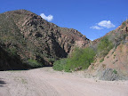
at Dudleyville, head west on dirt 2WD Freeman Road 12 miles, crossing a cattle
guard just before Arizona Trail tread meets the road at right by a carsonite post.
Park here off the road, or turn right (north) onto a rough track that leads about
0.3 mi. to an impromptu, more secluded parking/camping area at left. | |
AZ
Hwy 77 at Old Camp Grant Place. The
GET crosses the highway without vehicle parking amenities nearby. Instead follow
Aravaipa Road 0.5 mi. east to the small Central
AZ College Aravaipa Campus, where short-term
parking should be permissable (note the entrance gate may be closed at night &
on weekends / holidays - inquire within). For alternative parking, continue on
Aravaipa Rd (via the GET in Seg 6) an additional 1.8 mi. and turn left at a "no
dumping" sign onto a primitive dirt road (cars ok with care). This road passes
through a clearing then shortly reaches a gate. Park off the road before the gate.
| SEGMENT
OVERVIEW The
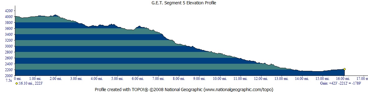
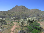
lone profile of tawny Antelope Peak presides over the first half of this enjoyable
segment. Eastbound hikers have been eyeing this eroded volcanic cone for miles,
and now finally get to inspect it at close range. The rolling, well-graded Arizona
Trail hiking experience is more cohesive here than in Segment 4, with less roadwalking
and more continuous treadway. Finally, though, the GET parts company with the
southbound-trending Arizona Trail, slabbing east in order to begin its approach
toward spectacular Aravaipa Canyon Wilderness (Segment 7). In the process our
route - a straightforward cross-country-via-wash experience now - passes near
perennial Putnam Spring, by far this segment's best (and other than the San Pedro
River, its only reliable) water source. Here the GET returns to a saguaro-studded
Lower Sonoran desert environment, and threads a picturesque, red-walled box canyon
on its way toward the lush, tree-lined oasis of the San Pedro River, which it
then follows for a serene and contemplative mile. Extending over 100 miles from
its source in Sonora, Mexico to the Gila River near Winkleman, the San Pedro is
one of the Southwest's finest remaining examples of a low-desert riparian-riverine
community. It is also a fragile and highly endangered ecosystem, due to long-term
regional drought compounded by unsustainable agricultural use of groundwater along
its length.
ROUTE
DETAILS From
a carsonite signpost junction of the Arizona Trail and wide, graded 2WD Freeman
Road, a 2010-completed section of singletrack intially parallels the road eastbound,
remaining on its north side. In 0.3 or 0.4 of a mile the winding trail returns
to Freeman Road and crosses it, just east of a cattle guard, then continues south
on a narrower dirt road. The tri-humped profile of Antelope Peak is straight
ahead, and the Santa Catalina Mountains near Tucson soon appear on the horizon.
Ignore occasional
roads heading off at left. At an AZ Trail signpost at 1.5 (mapset waypoint
05030) turn left (east) onto a lesser 2-track. The 2-track bends toward the south,
leading to constructed trail tread on the left in a short ways (waypoint 05040). Marked
at intervals by cairns, the trail descends through a shallow gully then contours
along the northeast side of Antelope Peak. At an elevation of 4000 feet, the plant
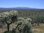
community here is Upper Sonoran, with mesquite, acacia, barrel cactus, prickly
pear, and especially chain-fruit (jumping) cholla on display. The
GET/AZ Trail undulates southward, negotiating via switchbacks a couple of minor
canyons. Camps could be made in the sandy washes here during dry weather. Beyond,
ascend to cross a faint ridgeline 2-track at 4.6. The 2-track rejoins at
5.1 by a wire gate. Pass through the gate to find the continuation of trail
on the left. Enter
a cattle-impacted area, with numerous stock paths crossing the constructed trail.
Proceed carefully ahead a short ways to a 4WD crossing at 5.6 (waypoint
05090). Antelope Tank, an undependable and
polluted stock pond, lies 0.3 northeast along the road. Cross
the 4WD road and follow cairns, soon crossing a minor wash, then climb via constructed
switchbacks to a viewful ridge, at 6.0. The Catalina Mountains draw ever
nearer to the south above Oracle, while to the east the seemingly unbroken wall
of the Galiuro Mountains belies the splendor of still-hidden Aravaipa Canyon.
Continue along the ridge complex to a switchback at 7.1, where the trail
begins a descent. Reach
wide, sandy Putnam Wash at 7.8 and turn left, east in this often "OHV-improved"
wash. (Westbounders look for an AZT carsonite post, cairn, and/or flagging
at the junction.) The pock-marked cliff ahead vaguely resembles a giant beehive.
Just beyond it, at 8.2, a 4WD road leaves the wash heading south. Welcome
to Beehive Well, a windmill-tank-corral affair
that often has some water. The windmill is inoperable and its well only produces
when the rancher turns on a gas-powered pump, but the large tank may hold a supply
regardless - don't expect AquaFina though! The small trough within the corral
is another possibility, sometimes with better water. As the sign says, "no
camping allowed" here, the standard rule near developed water sources in
cattle country. Here
the GET & AZT at last part company, some 70 miles after merging in the Superstitions.
The Arizona Trail now turns south along the 4WD road and remains a non-singletrack
affair for a number of miles, while the GET remains eastbound in Putnam Wash.
Continue easily if uneventfully to the confluence with Camp Grant Wash at 11.7.
(You may spot a windmill off to the right en route, likely non-functional.) The
surrounding dark, volcanic slopes of the Black Hills are populated by an impressive
density of saguaros, heralding the GET's return to the Lower Sonoran desert. At
the confluence our route turns left, east, still in Putnam Wash. First, though,
you may want to turn right to visit Putnam Spring
(in Camp Grant Wash) in 0.3 of a mile (waypoint 05150). Water sometimes flows
down the wash a ways, but the spring's source seems to be perennial - impressive
given its setting directly in the sandy wash, and likely a fault-controlled hydrologic
feature. The shallow spring flow - most easily collected by means of a pump filter
- tastes excellent and is a good alternative to Beehive Well, but be sure to treat
it since cows and OHVs have ready access to it. For the same reasons, you may
want to avoid collecting water downstream of the source. A leave-no-trace camp
could be made nearby, out of the wash. From
the confluence of washes at 11.7, follow Putnam Wash east below the steep,
narrow cliff walls, passing occasional cottonwood groves (and on weekends, the
odd off-road vehicle enthusiast, a popular passtime among the small-town locals).
Eventually the canyon widens with views of the San Pedro valley ahead. Reach
a railroad bridge spanning the wash at 13.8. Pass beneath the bridge at
its south end, following 2-track as it curves right, leaving the wash. Almost
immediately arrive at an offset 4-way road junction (waypoint 05155). Continuing
south here would lead a pleasant, mostly traffic-free 8.5 miles into the outskirts
of Mammoth - the best option for walkers looking to resupply in town (as opposed
to hitchhikers, who instead would continue along the main GET to AZ 77, which
carries plenty of high-speed traffic). The Mammoth-bound walking route is also
the way to go if following the Aravaipa Canyon Wilderness bypass route
described in Segment 6 (not preferable unless you can't get a permit for ACW;
there's also another detour option around Aravaipa Canyon Wilderness on the north
side, staying closer to the main route in Segment 6 and 7, that you can use if
you don't want to walk south through Mammoth). The main GET route instead turns
left at the 4-way junction, east, and follows a dirt road among mequite trees
one tenth of a mile to a T-intersection. Turn left at the T, north, passing through
a gate in a wire fence. In a short distance reach another T-intersection back
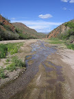
in Putnam Wash. (GPS here: 32 50.244 110 43.100) Turn
right (east) down the wash, reaching an opportune ford of the normally gentle,
ankle-deep San Pedro River just north of its confluence with Aravaipa Creek, at
14.2. Although often dry a few miles upstream, the San Pedro typically
flows in this area, nourishing a riparian community of cottonwoods, ashes, and
willows. The scene, especially continuing north, is very attractive - a wonderful
respite from the open desert - but it's best not to drink from the river here,
due to agricultural and ranching concerns upstream. The
recommended route of the GET now follows the San Pedro River north for about a
mile, rather than fording and continuing east into Aravaipa Creek's wash (which
has public access concerns where Highway 77 crosses it, as well as beyond). From
14.2, proceed north along the banks or else slosh up the normally shallow
creek where easiest. The riparian corridor becomes markedly more extensive just
upstream and is a wonder to behold. Plan to linger for a bit in this area, especially
eastbound hikers after miles of open desert travel without much access to water
or shade. Around 14.6 the wide, shallow drainage bends sharply east and
narrows; follow near the banks here as convenient, keeping the creek close at
hand to avoid the pervasive flood debris from 2006 deposited farther back in the
woods. Approaching
15.1 leave the creek and walk east to the edge of the flood plain, where
a primitive use trail climbs the embankment, (waypoint 05165) soon leaving the
riparian corridor behind. The trail appears to be used mainly by feral horses
and continues out to graded dirt PZ Ranch Rd, which we join at 15.6 (waypoint
05170) just south of a cattle guard. (The horse trail diverges occasionally; keep
right at junctions, avoiding any old 2-track roads as well as a private-posted
fenceline en route. The last part of the trail follows along the top of what appears
to be an old railroad grade.) Follow
PZ Ranch Rd south to Old Camp Grant Place at 16.1, then turn east to segment's
end at 2-lane, high-speed AZ Highway 77 at 16.3 (waypoint 06010). Cross
the highway with care if continuing on to Segment 6 from here.
|