G.E.T.
Guidebook
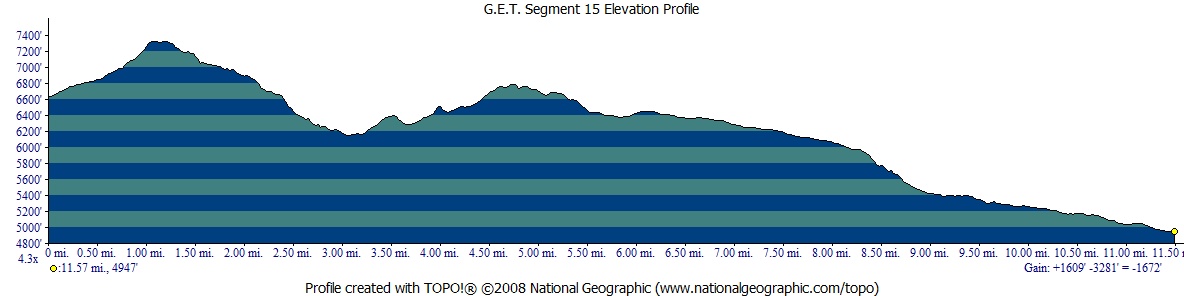
Segment 15: Coronado Trail 11.7
miles  Guidebook
Home Guidebook
Home
Open
this page for printing
Submit
feedback for this segment
|
Segment
Length | Segment
Status | Season |
|
|
|
11.7
mi. | finalized
& accessible | all
year | | Resources |
| OVERVIEW
MAP | 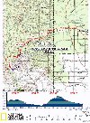 |
| ELEVATION
PROFILE | 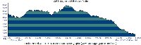 |
G.E.T. Topo Maps 44-45
Town Guide: Morenci/Clifton
Water Chart
Image Gallery: Album 5 |
Additional maps:
Clifton 1:100K Topographic (BLM)
Apache-Sitgreaves
National Forests (USFS)
Land management agency:
Apache NF Clifton Ranger District
BLM Safford Field Office |
| Beginning
access point | | Ending
access point | |
Granville Campground
From Clifton take
US 191 (Coronado Blvd) north ~3.5 mi to the town of Morenci. Continue on US 191,
passing Lower Eagle Creek Rd, the Morenci Mine overlook, and a large turnout on
the right at an unsigned switchback overlook. In another mile pass a second overlook
on the left (Chase Creek Vista). Continue through switchbacks another half mile
to an alternate ending access point for Segment 14 on the left at a hiker/equestrian
sign (a 2WD dirt side road leads a short distance to a parking area for Painted
Bluff Trail 13). Another 1.4 mi. on US 191 leads to signed Granville Campground,
~16 mi. from Morenci village. Trailhead parking for several vehicles is past the
restrooms on the left, enclosed by a low stone wall. | |
FR 475 at Pigeon Creek
Trail 465. From
Clifton take US 191 (Coronado Blvd) north ~3.5 mi to the town of Morenci. Continue
on US 191 - a winding, 2-lane mountain highway - north approx. 27 miles (or south
65 miles from Alpine) and turn east onto signed, graded 2WD FR 475 / Juan Miller
Rd. Pass Upper and Lower Juan Miller campgrounds. In ~5 mi from the highway reach
signed "Cow Canyon." A few car camping spots are ahead on the right,
acceptable for parking as well. These spots are just beyond a junction with a
4WD road, signed "Pigeon Creek Trail 465" (also signed FR 475E). Please
note that FR 475 is narrow, with mountain curves and grades, and may be impassable
to passenger cars when wet. | SEGMENT
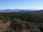
OVERVIEW When
Spanish explorer Francisco Vasquez de Coronado led his expedition across the Southwest
in 1540, he followed a route that ran close by today's Highway 191 from Clifton
to Alpine. Coronado came in search of the storied Seven Cities of Cibola - that
is, for gold - but today's visitor finds a more enduring treasure along the scenic
byway dubbed the "Coronado Trail" - mile after mile of untamed natural
splendor. The
GET in Segment 15 also passes this way, in turn following a route loosely described
by the two-lane mountain highway. Hikers arriving at the Granville Campground
trailhead to begin this segment, whether by foot or by vehicle, will already be
familiar with the torturous curves for which the Coronado Trail is (in)famous;
in fact there are several hundred of them en route to Alpine, the nearest town
for northbound touring vehicles. Trading asphalt for dirt, the GET soon rejoins
trail of the foot-traffic sort, contouring along the scenic slopes of 7000+ foot
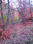
summits. Mitchell Peak, a lightly forested crest along a ridge faceted with crests,
typifies the complex topography here at the southern edge of the Blue Range, itself
only a portion of Arizona's vast Central Highlands region below the Mogollon Rim. Among
the Apache National Forest trails that the GET follows here are Granville Trail
572, Frye Trail 12, HL Canyon Trail 11, and Pigeon Creek Trail 465. The segment
ends at Forest Route 475, which is accessible to passenger cars in dry weather
and, with the segment's starting access point, offers a convenient option for
a one-way overnight trip. Forested camping is available in HL Canyon a little
over half-way along, with probable water at Frye Spring and Mud Spring. Frye Spring
is located along an alternate route in this segment, intended for use whenever
water may be hard to come by at Granville Campground.
ROUTE
DETAILS This
segment begins at an unsigned trailhead parking area at Granville Campground (waypoint
15010, elev. 6615'), just north of the public restrooms. Developed water is available
from any of several spigots in this area,
but only seasonally, from April to October usually. The campground road forms
a loop to the north; take the right fork, heading uphill and passing a couple
of longstanding summer cabins - private residences located on National Forest
land under a special use allowance. The road shortly levels out at another junction;
take the right fork again, possibly marked by a metal trail sign for Granville
Trail 572. The last cabin on the right appears to be in disrepair, but has a small
in-ground piped trough near the road which
can hold water year-round (be sure to ask permission first if anyone is home).
Follow the old
dirt road north-northeast, reaching a lateral fenceline (on either side of the
road) and another roadside metal trail sign (0.2, waypoint 15020). This
is the junction of Granville Trail 572 and Pinal Trail 713. Note the somewhat-hidden
wooden trail sign for Trail 713 is nailed to a tree on your right, just above
where singletrack climbs out from the road. Trail 713 is part of an alternate
route (the Frye Spring alternate) intended to provide access to Frye Spring, a
small but generally reliable water source, and one that long-distance travelers
may want to visit if unable to obtain water at Granville Campground. (The next
likely water north / east in this segment is at Mud Spring at mile 5.3.) Otherwise,
the main route may be preferred, since it's quite a bit more scenic. A brief description
of the Frye Spring alternate follows.
ALTERNATE
ROUTE: FRYE SPRING This
3-mile-long alternate route leaves the main route in Segment 15 at mile 0.2 (waypoint
15020) and rejoins it at 2.6 (waypoint 15060). Pinal Trail 713 initially proceeds
southeast along a fenceline, then turns northeast, climbing through a dense scrub
forest of pinyon, juniper, and scattered ponderosa pine, which offers restricted
views off to the south toward Chase Creek's canyon and the Morenci mine. The rocky
but easy-to-follow trail reaches a height-of-land from which it decends sharply
at first, then crosses another bench with some duff-ground camping opportunities
at trailside. Negotiating another little ridge, the now-secluded-feeling trail
commences a final descent, ending at a signed junction with Frye Trail 12 at 1.9
(waypoint 15040). Turn
left, following Frye Trail north.
Just ahead, the trail descends into a gully and turns right down it. Frye
Spring, several small pools fed by a pipe, is located due north at
this bend, off the main trail, less than 100 yards up the side drainage (2.0,
waypoint 15050). In wetter times, water may also be found just ahead along the
main trail; as it crosses the drainage three times, then leaves it on its left,
look down the embankment to the right for pools.
Past the spring area,
Frye Trail contours, with occasional ups and downs, to a saddle-top junction with
signed Granville Trail 572 at 3.0, and a resumption of the main route in
Segment 15.
From
the unsigned junction along the main route at 0.2, Granville Trail 572
continues northeast along the old 4WD road, signed as closed to motorized vehicles.
The road passes a cistern (no water noted in adjacent trough, cistern itself inaccessible)
and continues up the drainage, reaching another slightly obscure junction at 0.5
(waypoint 15030). Be on the lookout here for a trail sign on a tree located about
10 yards to the right, off the road, beyond which Trail 572 now continues as singletrack.
The trail is initially a bit vague but the way ahead is evident as it heads east
along the canyon bottom among shady Gamble oak and big-tooth maples. It then jogs
northeast to ascend an open slope of mountain mahogany, affording expansive vistas
to the west all the way beyond the canyon of Eagle Creek into the San Carlos Indian
Reservation. The
Granville Trail tops out along a level ridge at an elevation of around 7300 feet.
It then begins a gradual descent northeast through broken forest cover, revealing
truly remarkable views eastward. Grassland-juniper mesas and peaks rise over the
Blue River and San Francisco River watersheds in a dazzling spectacle of topographic
complexity. Near at hand is prominent Walker Butte, standing sentinel above the
sinuous canyon of Sardine Creek, the head of which we cross in several miles.
On the far horizon looms conspicuous Maple Peak, the major highlight of Segment
17 ahead on the route, and farther still, the nearly 11,000-foot-high crest of
the Mogollon Mountains (Segment 20), often snow-capped in early spring. Crossing
the dry head of a drainage, Granville Trail bends southeast along a sunny slope,
contouring and descending. Among the trailside chaparral, note the variety of
live oak species, including silverleaf and Mexican blue oak, occurring here near
the northern extent of their range.
The trail then trades the slope for the adjacent ridge, now with first views north
to nearby Mitchell Peak and a perspective on our route ahead. Pay close attention
to the trail underfoot, though, as it briefly leaves the rocky ridge crest to
jog south, bypassing an old trail layout that once bombed directly down the steepening
grade of the main ridge. You'll note where the old trail comes in again, and how
the new trail alignment is still rather steep, with awkward footing in this area.
Resuming a more easily tack, the trail heads directly across a small clearing,
marked by tree cuts at either end, then makes a final rocky descent to a saddle,
where we reach a signed junction with Frye Trail 12 at 2.6 (waypoint 15060).
(This junction marks the eastern end of the Frye Spring alternate route, described
above. Westbounders in need of water can remain on the Frye Trail to reach the
spring in a mile, then continue via Pinal Trail 713 to a resumption of the main
route near Granville Campground, which has developed water seasonally. The next
likely water is 10 miles beyond the campground at Cottonwood Spring in Segment
14.) Turn
left (west then north) on Frye Trail 12. The
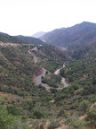
trail heads down from the saddle, dropping steeply toward a maple-blessed side
canyon, its crimson canopy a feast for the senses in autumn. The trail here has
recently been confused by game paths; if you find yourself confronting braided
tracks on the forested slope then you may have missed where the correct trail,
somewhat overgrown, makes a sharp turn to follow directly down the drainage -
backtrack and look carefully for cairns and/or flagging. Beyond the leafy glade
the trail again contours onto arid slopes, then resumes its descent, bottoming
out in the main drainage of Sardine Creek,
which only occasionally holds water, such as in small pour-offs at trailside.
Follow the trail up-canyon along the north bank of the riparian drainage, then
as it climbs northeast rather steeply away toward a viewful flat. Frye Trail 12
ends here, at a signed junction (3.4, waypoint 15070, elev. 6400'). Here,
HL Canyon Trail 11 runs both left and right. Follow it right (east). (Trail 11
forms a loop around Mitchell Peak, the prominent high point to the northwest,
and is accessible from US 191.) (Westbounders, take the left fork at the signed
trail junction onto Frye Trail 12, toward Sardine Trail 10, per the sign.) HL
Canyon Trail, where concurrent with the GET, was last cleared of brush in fall
'09 by the author; previously the trail was rather overgrown with live oak and
New Mexico locust (and at this point may well be again). Pass evidence of an old
corral, and descend toward a signed junction with Walnut Spring Cut-off Trail,
at 3.6 (waypoint 15080). (Walnut Spring,
reliability unknown, is ~1.4 mi via this side trail.) Turn left, staying on HL
Canyon Trail, and immediately passing a large cairn. (Westbounders, turn right
beyond the cairn.) The
trail traverses obviously across a shallow, cottonwood-studded canyon draining
from Mitchell Peak, the first of several in the next few miles. It then ascends
on an eroded surface of white volcanic tuff to a viewful point. Here it bends
north, crossing a drainage, then contouring around another. A sidehill climb leads
to a junction with Trail 703, signed "Walnut Spring 1 mile." (4.3,
waypoint 15090) The junction is rather vague; keep left, remaining on HL Canyon
Trail, which climbs northeast on faint tread with occasional cairns. (Westbounders,
remain on HL Canyon Tr, which bends right (west) and descends.) Traverse
above some eroded cliffs, with fine views south toward Pinal Point and the peaks
above Morenci mine (often seen through localized haze caused by airborne dust
from the mine). The cairned trail trends northeast along the slopes, now with
the juniper-clad expanse of Prieto Plateau in view, Maple Peak and the distant
Mogollon Mountains beyond. Pass between a pair of old wooden posts, then follow
the trail left (north) along a fenceline, reaching a gate in 100 yards. Here,
in a fenced enclosure at 5.3, is Mud Spring,
a seemingly reliable, pipe-fed cement trough. The nearby ground often appears
to be muddier than the spring source itself, and the trough is often full and
clear. Eastbounders, fill your bottles here, as the next sure-fire source in drier
times is nearly 15 miles away at the Blue River in Segment 16. (Westbounders,
follow along the fenceline beyond the spring, then in 100 yards turn right, away
from the fence, passing through a pair of old wooden posts.) The
trail resumes a viewful northward traverse, passing a small, relatively rock-free
potential camp spot on eastbounder's right, about a quarter mile north of Mud
Spring. A similar distance north of the campsite the trail passes near tiny, fragile
(and often dry) McBride Spring on the left,
which is actually located just beyond (at contour) where the trail descends right
to bottom out in HL Canyon. (Westbounders, McBride Spring is just to the right
of the main trail after the initial short climb out of HL Canyon.) The shallow
rockbound pool was almost unusable upon first observation, and tasted strongly
of tannins, but would nonetheless be a convenient source if camping nearby. Trail
11 crosses the usually dry drainage in HL Canyon and comes to a prominent t-junction
(5.7, elev. 6400') at a cairn and sign, where it heads left. Our route
instead turns right (east), joining Trail 312. Trail
312 soon reaches an old stone corral. Here a semi-cleared area among the rocks
would offer one of the better camping spots since the start of the segment, with
ponderosas, sycamores, and stately oaks lending a sheltering, secluded ambience.
Just beyond the corral the trail reaches an opening in a fenceline. Don't pass
through, but instead turn left on the trail that leaves the drainage. This is
unsigned Pigeon Creek Trail 465. The trail parallels the fence for 100 feet, then
passes through another opening at a wire gate and continues uphill along its opposite
side. Soon the fenceline jogs away, and the trail ascends to reach another fence
with a gate at 6.0 (waypoint 15110). Beyond the gate, Trail 465 becomes
vague, then fades out entirely. But Trail 465 resumes as an obvious 2-track road
near Wing Tank in less than half a mile. To reach the tank, head northeast, initially
cross-country (possibly flagged) along the pinyon-juniper clad mesa. Reaching
a cairn, join an old dozer track that continues along the northern edge of the
mesa, then at a pair of cairns join some semblance of foot trail which heads east
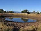
south-east, ending at a corral containing Wing Tank,
an earthen wildlife pond that often holds some water. As of 2015 the corral also
contained a small plastic cattle trough fed
from an adjacent cistern (with water apparently piped in from somewhere up-canyon).
Head through the corral to reach the obvious 2-track road at 6.4 (waypoint
15120). (Westbounders, to reach HL Canyon from Wing Tank, pass through the
corral obliqely, possibly guided here by a metal trail sign. Foot trail heads
west northwest from the sign, then joins an old dozer track at a pair of cairns.
Follow the track along the edge of the mesa. The track eventually fades out at
another cairn; here continue cross-country toward the southwest (possibly flagged),
reaching a fenceline spanning the mesa and seek out a gate near the mesa's southern
end (waypoint 15110). Pass through the fence gate and follow the resumption of
Trail 465 (now singletrack again) southwest, traversing down off the mesa. The
trail passes through another fence opening at a wire gate, soon reaching the drainage
of HL Canyon by an old stone corral.) From
the corral and tank, the recommended route of the GET turns right on the narrow
2-track road (FR 475E). (A left on the road leads a similar distance toward the
end of this segment but is less wild and scenic.) The little-used track comes
to a junction in about 0.2 of a mile - keep left, soon passing a flat vehicle
camping spot that likely receives little use. The road continues east along a
broad ridge, passing near another potential cattle trough
on the left at 7.4. In another half mile keep straight at a road junction
by a gate in a wire fence (waypoint 15124). Following near the fence, the 2-track
becomes increasingly primitive until little more than a game path along the rocky,
narrowing crest of the ridge. Find any convenient route down the final, steepening
portion of the ridge to a saddle at 8.6 (waypoint 15126), where the GET
joins another primitive 2-track by a gate and turns left, north. The
steep, rocky 2-track road switchbacks down to cross a drainage then passes through
an old corral, which would make for a shady rest break in this increasingly open
landscape. The road (FR 475D) remains closed to vehicles in its upper reaches
via a series of berms, encountered around 10.1. Areas of exposed bedrock
- weathered ash-flow tuff - lend a slickrock air to the landscape as the road
continues an undulating descent generally northward. Choose either road fork at
10.8, as the two meet up again ahead (the right fork might be the easier
of the two to follow). Reach a junction with FR 475E at 11.5 (waypoint
15140) and merge right, northeast onto this better road. The road passes near
an unreliable stock pond (Chi Chi Tank per
some maps, sometimes of good quality, sometimes not), then crosses the unreliable
drainage of Pigeon Creek. FR 475E (aka Pigeon Creek Trail 465 per signs) ends
at a junction with 2WD FR 475 (Juan Miller Road), at 11.7 (waypoint 16010,
elev. 4950'). |