G.E.T.
Guidebook
Segment
4: Tortilla Mountains 27.6 miles
 Guidebook
Home Guidebook
Home
Open
this page for printing
Submit
feedback for this segment
|
Segment
Length | Segment
Status | Season |
|
|
|
27.6
mi. | finalized
& accessible | fall,
winter, spring | | Resources |
| OVERVIEW
MAP | 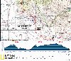 |
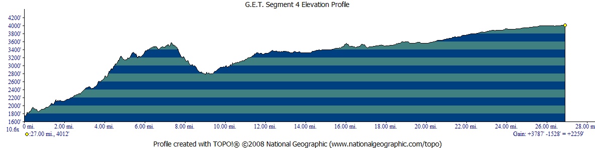
| ELEVATION
PROFILE | 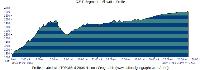 |
G.E.T. Topo Maps 9-12
Water Chart
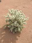
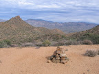
Image Gallery: Album 2
| Additional
maps:
Mesa
1:100K Quad (BLM)*
Globe 1:100K Quad (BLM)*
Casa Grande
1:100K (BLM)*
Mammoth 1:100K (BLM)
*limited coverage shown
Trail managing agency:
Arizona Trail Association |
| Beginning
access point | | Ending
access point | |
Florence-Kelvin Road
at Kelvin-Riverside bridge.
Take AZ 177 south from Superior or north from Winkelman. Turn off at sign for
the village of Kelvin onto Florence-Kelvin Road. Follow this paved 2-lane road
1.3 miles, through Kelvin (no services) to Kelvin-Riverside bridge over the Gila
River. A dirt turnout is south of the bridge at a junction with Riverside Rd on
the left. Alternate parking: For longer term parking, instead continue
south on Florence-Kelvin Road for ~2mi to a large Arizona Trail parking lot on
the left. The AZT / GET crosses the parking lot here, at MP 2.0 along the GET
in Segment 4. | |
Arizona Trail at Freeman
Road. From AZ 77
at Dudleyville, head west on dirt 2WD Freeman Road 12 miles, crossing a cattle
guard just before Arizona Trail tread meets the road at right by a carsonite post.
Park here off the road, or turn right (north) onto a rough track that leads about
0.3 mi. to an impromptu, more secluded parking/camping area at left. |
SEGMENT
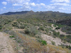
OVERVIEW The
remote Tortilla Mountains extend south from the Gila River toward the distant
Santa Catalina sky island range, and we follow their lead in this segment, winding
among Sonoran desert foothills and mesquite-lined washes, and encountering few
if any people. Except for the first 8 miles or so, the terrain here is fairly
mellow. Navigation is also relatively straightforward, though the Arizona Trail
route that you'll follow changes surfaces frequently - from singletrack to 4WD
road and back - so be alert at junctions and look for cairns, posts, and flagging
leading the way through this interesting rolling country. You'll likely find some
stock trough water in the first half of this segment, and particularly in springtime
a pair of public water caches are typically maintained for AZ Trail hikers, one
located 2 miles into the segment and one at the very end. Otherwise the terrain
is likely to be dry. (For the most recent status of Arizona Trail water caches,
see the aztrail.org website "Water Sources" links.)
ROUTE
DETAILS The
segment begins just south of the Kelvin-Riverside bridge over the Gila River.
(The Gila is generally unpotable here, but developed water is available in the
community of Kelvin to the north. See Chapter 3 for more information.) 2011-built
Arizona Trail tread leaves the road at right beyond the bridge. The trail climbs
above the Gila River, then meanders west through Sonoran desert scrub, crossing
a prominent wash at 0.9 (waypoint 04020). At 2.0 miles, it reaches
Florence-Kelvin Road again (now graded dirt), crossing it at a large Arizona Trail
parking area. In recent years an Arizona Trail Association-provided metal
cache box has been available, located alongside the trail just below
the parking area, and typically stocked in springtime. The
trail heads south from the parking lot at Florence-Kelvin Rd, passes beneath power
transmission lines, then through a gate at 3.8 (waypoint 04060). Beyond
the trail climbs moderately
with the aid of switchbacks to crest a gravelly ridge, where occasional large
cairns guide the way along the meandering height of land. The town of Kearny comes
into view off to the east, well below, along the banks of the Gila. Trail tread
may disappear momentarily on the approach to the "Big Hill," (as the
trail community has unofficially named the little conical peak) but the way ahead
is straightforward enough. Soon rejoin constructed trail near 7.3 (elev.
3526') and begin a well-graded descent toward the west via switchbacks. The views
here are commanding, with the White Canyon Wilderness visible to the north, the
Tortilla Mountains toward the south (including the gumdrop profile of Antelope
Peak, approached in Segment 5), and the Santa Catalina Mountains' skyline far
beyond. Even Picacho Peak is visible, the oft-climbed volcanic plug charging skyward
on the western horizon. Foot
trail continues into a minor canyon (waypoint 04110) then reaches a wider wash
by a metal gate at 8.8. Walk southeast down the wash, watching for a large
(but somewhat hidden) cairn on the left (waypoint 04130). Trail tread leaves the
wash here, continuing to a cairned crossing of wide Ripsey Wash at 9.3
(elev. 2821'). Turning
left (south) along the west side of Ripsey Wash leads to a spring-fed
trough in under 0.2 of a mile (waypoint 04150). The trough often contains
some water, although its float valve doesn't work well of late and may be producing
only a trickle of fresh water - if any; otherwise you can follow the PVC pipe
to the spring source in the cliff above, sometimes quite shallow and hard to collect
from. Camping is possible in the vicinity, but avoid the main branch of the sandy
wash itself in case of vehicles. Crossing
the wash, our AZT/GET route continues as foot trail once more, climbing a minor
ridge to a 4WD road junction by a powerline at 10.1. Continue straight
on the road, which descends west to cross a drainage at 10.4. Just beyond,
the trail veers left off the road onto constructed trail again (but first you
may want to continue west along the road another 0.1 mile or so, possibly following
a black water line, to a float-valve-controlled metal
trough, good in recent years - in fact more reliable than the next
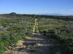
source another 0.4 mile along the trail). The shared AZT/GET singletrack trail
now undulates rather moronically in and out of the wash. (Superior-bound
hikers: the Arizona Trail joins the road, then stays right at an unsigned junction
with another road, and climbs to a signed junction atop a ridge, where foot trail
soon resumes.) At the trail's 4th crossing of this wash, 40 yards to the west,
is a "100 gallon stock trough,"
near 10.8 (waypoint 04180). One or two metal troughs are often found here
and sometimes with water in one or both, but they may also contain sand and debris
at other times; the PVC inlet pipe can produce a trickle of water that you can
collect from directly. Climb
to reach a gate on a viewful ridge at 11.7, where constructed trail ends.
Turn right and follow a 2-track road, which bends south to soon reach a better
2-track (waypoint 04200). Turn left onto this road, watching for helpful flagging
and/or cairns. A tenth of a mile beyond, bear right at a 3-way road junction.
Take the left fork at 12.5, continuing southeast. Pass
through a gate at 13.7, and turn right, west, along the fenceline on a
old 2-track. Turn left
where foot trail resumes in a tenth of a mile (waypoint 04240). The trail wanders
through an intriguing upper-Sonoran desert landscape, crossing a couple of old
2-tracks (and a number of confusing stock paths) along the way. Constructed trail
may end at a 2-track crossing at 15.3. If so, turn right here, following
the 2-track a short distance over to a powerline service road. Here bend left
and follow the rough road south. (Westbounders: the turnoff of the powerline
road may be marked by a cairn.) The road climbs to the left of a low hill,
then reaches an unsigned t-junction in a drainage at 16.2. Turn right here
on the road that heads down the drainage. Reach
a better road at 16.8. Heading right (west) here would lead to the Old
Ripsey Ranch corral, with a windmill and possible trough,
in a half mile, a potential detour if you're low on water. (Camping is not allowed
at the corral.) Our route instead follows the road left to cross beneath the powerline
twice, then at 17.2 reaches a cairn at constructed AZ Trail tread (waypoint
04300). Turn right onto the trail. The
tread can sometimes be overgrown and indistinct here, but is blazed with occasional
cairns and reflective aluminum markers tied to brush. Reach
a well-defined wash at 18.2. Cross 2WD dirt Old Florence Road at 19.1,
then pass through a metal gate and traverse around a viewful knoll. The Ninety-Six
Hills stand low toward the southwest, while southeast beyond nearby private Tecolote
Ranch rises the tawny cone of Antelope Peak. The Santa Catalina "sky island"
range inches closer on the southern horizon above Oracle. Descend
from the knoll to cross a wash. More recently-built trail begins within a half
mile, cruising easily southward among agave, yucca, and mesquite. Although the
terrain is fairly flat, small ridges and washes add enjoyable texture. Cross a
4WD road at 20.8, and then a pair of shady washes offering camping prospects.
Beyond, soon skirt "the Boulders" - an assortment of weathered granitic
outcrops similar in composition to the rocks atop Mount Lemmon in the Catalinas.
Pass through a gate at 21.9, then cross a hackberry-lined wash a couple
of times to reach a gas pipeline service road at 23.6. Signed
trail continues beyond the pipeline road, crossing a pair of 2-tracks - the second
set just after descending beneath the powerline once again. At 25.3 (waypoint
04430) meet graded, 2WD Hayden Ranch Rd, and another road of similar quality shortly
beyond. Constructed trail ends at another gas pipeline road at 25.8. Turn
right, south, following the undulating, arrow-straight track (ignoring any turnoffs)
to 27.0, where singletrack trail resumes at left (east). The AZT/GET rambles
pleasantly once more among upper-Sonoran vegetation, passing an official public
water cache box just off the trail at right, less than 0.1 of a mile
before arriving at graded 2WD dirt Freeman Road at 27.6 (waypoint 05010;
elev. 4012'). When stocked and maintained, the public cache for Arizona Trail
hikers is generally obvious - a metal box containing (and/or surrounded by) as
many as a couple dozen (although often fewer) plastic gallon jugs of water, sometimes
with an Arizona Trail hiker register.
|