G.E.T.
Guidebook
Segment 25: Lookout Mountain 11.5
miles  Guidebook
Home Guidebook
Home
Open
this page for printing
Submit
feedback for this segment
|
Segment
Length | Segment
Status | Season |
|
|
|
11.5
mi. | finalized
& accessible | spring,
summer, fall | | Resources |
| OVERVIEW
MAP | 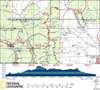 |
| ELEVATION
PROFILE | 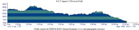 |
G.E.T. Topo Maps 65-67
Town Guide: Winston
Water Chart
Image Gallery: Album 7 |
Additional maps:
Gila National Forest (USFS)
Land management
agencies:
Gila
NF Black Range Ranger District
|
| Beginning
access point | | Ending
access point | |
FR 226A at CDT (Trail
74). 5 miles north
of Truth or Consequences NM take exit 83 off Interstate 25 onto paved NM 181 North,
then turn left onto paved NM 52 (west). In ~31 mi. from I-25, reach community
of Winston (last gas station). Continue
~10 more mi. and turn left onto paved NM 59. Follow ~13 miles to signed crossing
of Continental Divide. Continue ~1.6 mi. and turn left (south) onto dirt FR 226,
then left onto FR 226A (both high-clearance & 4WD advisable) toward Lookout
Mountain. ~11 miles from NM 59 reach signed CDT crossing. Park along shoulder. | |
NM 59 at CDT (Trail 74).
5
miles north of Truth or Consequences NM take exit 83 off Interstate 25 onto paved
NM 181 North, then turn left onto paved NM 52 (west). In ~31 mi. from I-25, reach
community of Winston (last gas station).
Continue ~10 more mi. and turn left onto paved NM 59. Follow ~13 miles to signed
crossing of Continental Divide. Continue 0.5 mi. to CDT trailhead and parking
on the left. | PLEASE
NOTE: THIS CHAPTER REMAINS UNFINISHED. SEGMENT OVERVIEW AND ROUTE DETAILS INFO
BELOW ARE IN DRAFT FORM AND HIGHLIGHT ONLY THE ESSENTIALS NEEDED FOR NAVIGATING
THIS SEGMENT IN CONJUNCTION WITH THE TOPO MAP SET. SEGMENT
OVERVIEW The
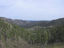
Continental Divide atop the remote Black Range is less prominent in this segment,
more forested, and provides for easier passage in comparison to the early miles
of Segment 24. However, because terrain features are somewhat nondescript, in
spite of their continued ridge-and-canyon complexity, it can sometimes be difficult
to ascertain one's bearings here. This would not be much of a concern if the CDT
were well defined and clearly marked. Alas, in the first 4 miles or so of this
segment, the CDT is not always that. In fact, the trail can be rather confusing
to follow in places, particularly as there is more than one route marked as the
CDT: a former route that tends to hug the physical Divide more closely, marked
with i-blazes and occasional wooden CDT markers on trees, as well as a newer route
signed with the more familiar, blue-and-black metal CDT markers on trees. Trail
maintenance in recent years (tread improvement, cairning, blowdown removal) has
helped somewhat, while the following guidebook description aims to further minimize
any head-scratching here. Once
the trail gets its act together - which it does finally do - navigation is quite
undemanding. The well-plotted and -graded trail contours this way and that along
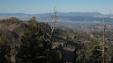
the broad, ponderosa-clad crest of the Continental Divide, offering up occasional
glimpses east toward the San Mateo Mountains and nearer Cuchillo Hills, or west
toward sere grasslands and island-like forested ridges of northern Gila country.
The easy transit here also has an added advantage, ferrying one expediently along
an increasingly droughty trail corridor. The most reliable opportunity to fill
water bottles between Seg 24's Chloride Creek and Seg 26's Adobe Spring appears
at this segment's halfway point, a trio of small springs in separate drainages
off the Divide. The spring-fed trough located east of the trail remains the only
one yet explored firsthand, seemingly fragile, but never reported dry.
ROUTE
DETAILS From
signed CDT trailhead along FR 226A, the summit of Lookout Mountain - at 8870 feet,
one of the higher peaks in the vicinity - is a couple of miles east via the road,
featuring a lookout tower, and might make for a scenic diversion. Immediately
north of the gate the CDT bends toward the right while another trail - actually
an old fire line cut - goes straight and was blocked with debris in an attempt
to limit any confusion. 2000's-era trail maintenance had made the CDT somewhat
easier to follow now as climbs east, soon topping out on flat, burned ridge. At
around 0.1 of a mile since the gate, look for a large covered fiberglass
tank perhaps 50 feet off-trail (this was first reported in fall of
2017, 15 feet in diameter and full of good water at that time). Trail now turns
north through a small, spotty 2007 burn, sometimes without much tread evident.
But trail and terrain conditions improve as the trail turns east again in a couple
hundred yards, contouring along north side of height of land. Better established
after first or second gully contour where it mostly exits this particular burn.
Gate in wire fence at saddle at 1.2 - trail passes through -
a reassuring landmark. First
junction with former (now abandoned) CDT route to Franks Mountain (mapped dashed
line) not really evident, so need not be concerned here. However, those heading
the other way (toward FR 226A trailhead, aka westbounders) can be led astray at
2.1. Tread can be quite vague along correct CDT route in upper part of
semi-burned gully just south of 2.1 (has a few CDT metal markers on trees, but
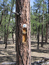
these are easy to miss). Physical Divide all along the top of the ridge features
i-blazes (bark cuts) on trees, and possibly some old wooden CDT markers on trees,
continuing toward Franks Mountain as well as over the summit of peak 8843. Bottom
line: all of the mapped black dashed lines here should be carefully avoided, as
it's possible to be lured onto them by mistake. Beyond
2.1, correct CDT route from FR 226A trailhead contours below peak 8843 on established
tread with occasional metal CDT markers. It returns to the physical Divide west
of peak 8843, where those heading the other way should again be careful not to
continue up the ridge toward that peak. Now the correct CDT route heads vaguely
with tree cuts and metal CDT markers through another small burn area, then meets
a wire fenceline (yellow dashed line) at 3.1, which it crosses without
the aid of a gate at waypoint 25050. (This fence was apparently constructed around
2007 for the benefit of the grazing allotment, not the pre-existing National Scenic
Trail. More recently a gate was added in a perpendicular fence immediately west
of our hop-across point. Ignore this gate. The trail continues SOUTH of all fences
when heading north along the CDT here) The trail then generally parallels the
fence at a distance of 10 or 20 yards, with greater or lesser degrees of obviousness.
Returning to the fence once more, the trail follows along it for a short distance
without crossing it, then turns west away from it for good. (Those heading
toward FR 226A trailhead, upon meeting the fenceline, the trail follows along
it briefly without crossing it, then turns away to then parallel it at some distance,
and finally returns to and crosses the fence without a gate at waypoint 25050.) CDT
tread remains a bit vague as trail continues along broad, forested (mostly unburned)
crest of the Divide - look carefully for i-blazes, metal CDT markers, and small
cairns. But trail gradually improves, then becomes quite good approaching 6.1.
Important potential water source 0.3 mi. east of Divide; leave CDT at flat campable
saddle (waypoint 25070), passing through wire gate. Folow vague trail tread along
northerly (left) slope above gully, which finally drops steeply into the gully
itself at an spring-fed metal trough alongside
drainage. Water in trough sometimes rusty, or look for good
small pools in eroded portion of drainage here. 250 vertical feet below
Divide. In the as-yet-unheard-of case of finding no water here, backtrack to Divide,
then seek out springs to west (approx. 0.8 mi. from Divide; connecting trails
and source reliability unconfirmed). From
6.1 to around 8.5 (and to a lesser extent before 6.1 as well) the CDT served as
a fire line during a 2010 fire that burned low to the ground (a beneficial fire).
Due to the use of ATV's in fighting the fire (and keeping it east of the trail)
the excellent singletrack trail had become something of a 2-track in places, but
had largely recovered to a single-wide corridor by 2014. In any event, this section
remains a good walk, with the easy-going trail contouring along the broad, forested
crest of the Divide. At 8.5, pass through gate & stile approaching
Kline Mountain. Junctions with little-used jeep roads thereafter typically not
confusing. At 10.7, CDT crosses better jeep road to begin newly
built trail section that avoids former walk along this road (the mapped road that
heads due north to reach NM hwy 59 at the physical Divide). This purpose-built
trail, again heading through a portion of the burn described above (minus the
associated trail damage), descends leisurely through a shallow canyon to reach
a CDT trailhead (with vault toilet and information board, but no water) at NM
59 about a half mile west of the Divide (11.5, waypoint 26010).
Hikers planning to resupply in Winston would hitchike east along the highway here,
or else continue about 30 miles (north / east) to NM Hwy 52 - see the Town
Guide for more info. |