G.E.T.
Guidebook
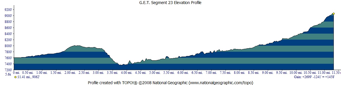
Segment 23: South Diamond Creek 11.5
miles  Guidebook
Home Guidebook
Home
Open
this page for printing
Submit
feedback for this segment
|
Segment
Length | Segment
Status | Season |
|
|
|
11.5
mi. | finalized
& accessible | spring,
summer, fall | | Resources |
| OVERVIEW
MAP | 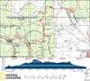 |
| ELEVATION
PROFILE | 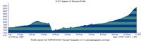 |
G.E.T. Topo Maps 62-64
Water Chart
Image Gallery: Album 7 |
Additional maps:
Gila National Forest
(USFS)
Land management agencies:
Gila
NF Wilderness Ranger District
|
| Beginning
access point | | Ending
access point | |
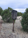
FR 150 at Trail 707 trailhead.
Join NM 35 north
per Seg 22 Beginning Access Point "asterisked" directions. Follow NM
35 past community of Mimbres to Mimbres Ranger Station and continue ~5 miles to
signed turnoff for FR 150 (North Star Road) on right. Follow graded dirt FR 150
(can be rough in places, with several long grades) approx. 25 miles and turn right
on signed 2WD FR 61 to Me Own fire/helitack site. Follow road clockwise around
admin. site building and pass through gate by corral (toilet and water spigot
nearby). Continue via 2-track 0.25 mi. to small turnout by Aldo Leopold Wilderness
boundary at Trail 707. | |
Trail 69 at CDT (Trail
74). This segment
ends within the Aldo Leopold Wilderness atop the Black Range Crest (Continental
Divide), at a remote location accessible only on foot or horseback. For the nearest
vehicle access to the east (north), see the Ending Access Point for Segment 24. |
PLEASE NOTE:
THIS CHAPTER REMAINS UNFINISHED. SEGMENT OVERVIEW AND ROUTE DETAILS INFO BELOW
ARE IN DRAFT FORM AND HIGHLIGHT ONLY THE ESSENTIALS NEEDED FOR NAVIGATING THIS
SEGMENT IN CONJUNCTION WITH THE TOPO MAP SET. SEGMENT
OVERVIEW Our
mellow tour of Middle Gila country concludes in this segment with a final push
to the Continental Divide atop the Black Range, the culmination of an extended
walk up the secluded canyon of perennial South Diamond Creek and its tributary.
The trail in fact drops a sharp ~500 feet initially, leaving a pinyon-juniper-ponderosa
mesa to switchback down to the bottom of South Diamond, whereupon it heads up
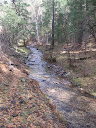
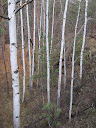
the gentle canyon grade to regain lost elevation. The creekside environment harbors
mixed riparian and conifer forest, with stately Douglas fir and Englemann spruce
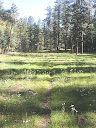
present farther up-canyon, as well as beautiful wildflower meadows by mid-summer.
Bear and elk are common, if elusive, visitors. The
walking here consists of the now-standard occasional crossings of a minor creek,
typically dry in places, reliable in others. Per usual in this type of environment,
the trail tread is occasionally vague due to limited use and sporadic flooding,
or becomes divergent in open meadows. Nevertheless the trail remains generally
in the flat-floored drainage and on adjacent benches, and the terrain is relatively
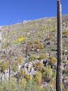
open so forward progress comes easily. Aptly-named Burnt Canyon farther east presents
a marked contrast to the luxuriance of South Diamond Creek, having burned over
within the last two decades along with upper South Diamond proper. Although navigation
here is no more challenging than elsewhere in the segment, and the trail in Burnt
Canyon has seen a work crew in recent years, nevertheless some timber continues
to drop across the corridor, and thorny New Mexico locust can make for unpleasant
going in a few spots (all very minor at last check). Rewards include wide-open
views and a chance to witness fire's restorative role in forest health (despite
the burn's severity, the forest is clearly on the rebound, ultimately the stronger
for it). Finally the trail leaves the burned terrain behind as it climbs in earnest
the final mile to the Continental Divide, with forested camping prospects available
along the way.
ROUTE
DETAILS Me
Own Trail 707 begins as several parallel tracks, proceeds east in pinyon-juniper.
(Cairned but unsigned jct at 1.7 potentially confusing for westbounders,
who should continue straight, avoiding left fork.) East of Me Own Hill, Tr
707 bends more northeast, but another trail - less obvious at first but possible
to take by mistake - goes to Me Own Tank (stock pond). If so, head north from
tank to rejoin Tr 707 above mesa drop. Reasonably well-graded descent via short
switchbacks reaches Tr 68 along south side of South Diamond
Creek at 3.9. (Westbounders, watch carefully for junction
with Tr 707, marked by a wooden signpost on left, and be sure to collect water
before starting ascent.) Straightforward
navigation east along Trail 68. Usually close to creek on one side or the other,
but occasionally climbs above briefly to shortcut bends or narrows in first half
of canyon walk. A few good established campsites en route, but possibilities are
many. Don't despair if drainage dry at a particular crossing; some further crossing
likely to be wet, or in Burnt Canyon. (Don't camp in Burnt Canyon due to potential
hazards from falling trees.) Entrance
to Burnt Canyon / Trail 69 at 8.6 (waypoint 23070) is obvious due to severe
burn terminating literally right at confluence with South Diamond Creek Canyon
& Tr 68. Trail sign, nailed to nearby tree, less obvious. In any case, head
up Burnt Canyon to find trail within a few hundred yards. Navigation again straightforward,
though canyon narrower, v-shaped, with some awkward crossings of small
creeklet (excellent water despite burn), and just very sporadic blowdowns
to negotiate at last check. (Continuation of Tr 68 toward Divide also encounters
burned terrain, as well as missing Diamond Creek and fine views in vicinity.) Burn
mostly ends where trail leaves Burnt Canyon drainage at 10.5 (waypoint
23080), begins easterly climb to Divide (last water before Diamond Peak Spring
in segment 24). Ascent is well graded through mixed conifer forest. Possible camp
on flat portion of ridge on eastbounder's right at waypoint 23085. Last 30 yards
to Divide and junction with CDT sometimes obscure, overgrown. (Westbounders,
immediately upon reaching low point / flat saddle south of Diamond Peak at waypoint
732, hopefully note trail sign/post on right. Turn right (west) to find good Trail
69 within 30 yards or so.) |