PHOTO
& VIDEO GALLERIES PHOTO
& VIDEO GALLERIES
An Illustration
of the G.E.T. from Phoenix to Albuquerque
| | |
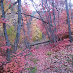
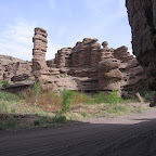
1.
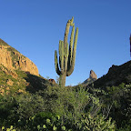
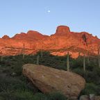
SUPERSTITION
MOUNTAINS
GET
west terminus to US 70 near Superior First
Water Trailhead, Dutchman Trail, Weaver's Needle, Upper La Barge Box, Rogers Canyon,
and other highlights of the GET in and around the Superstition Wilderness of the
Tonto National Forest.  Guidebook: Segment 1 |
2
Guidebook: Segment 1 |
2
|
| | | |
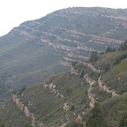
2.
WHITE CANYON
WILDERNESS & TORTILLA MOUNTAINS
US 70 near Superior
to AZ 77 near Mammoth Picketpost
Mountain, White Canyon Wilderness, and the Tortilla Mountains, south and east
to Putnam Wash and the San Pedro River near Mammoth.
Guidebook: Segment 3 | 4 | 5
|
| | | |
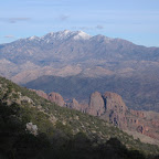
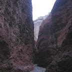
3. ARAVAIPA
CANYON & SANTA TERESA - PINALEÑO SKY ISLANDS
AZ
77 near Mammoth to US 70 at Safford Aravaipa
Canyon Wilderness, Santa Teresa Wilderness and Holdout Canyon, Mt Graham and the
Pinaleños, east to the Gila River Valley at Safford.
Guidebook:
Segment 6 | 7 | 8
| 9 | 10 | 11
|
| | | |
4. OLD
SAFFORD-MORENCI TRAIL, EAGLE CREEK & PAINTED BLUFFS
US
70 near Safford to US 191 above Morenci The
desert Gila Mountains of Arizona, Bonita Creek, canyon of Eagle Creek, easward
into the Apache National Forest, and along the Painted Bluffs to the Coronado
Trail north of the Morenci Mine and Clifton.
Guidebook: Segment 12 |
13 | 14
|
| | | |
5.
BLUE RANGE,
BLUE RIVER & MAPLE PEAK
US 191 above Morenci AZ
to US 180 at Alma NM The
Blue Range near Mitchell Peak, north to Pigeon Creek, east across the canyon of
the Blue River to Maple Peak, the AZ/NM state line, Sunflower Mesa, and the villages
of Alma and Glenwood New Mexico.
Guidebook: Segment 15 |
16 | 17
| 18
|
| | | |
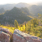
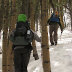
6.
MOGOLLON MOUNTAINS
& WEST FORK GILA RIVER
US 180 at Alma to NM 15 near
Gila Hot Springs Catwalk
National Recreation Trail, South Fork Whitewater Canyon, Mogollon Crest, West
Fork Gila River, east to Gila Cliff Dwellings National Monument near the community
of Gila Hot Springs.
Guidebook: Segment 19 |
20 | 21
|
| | | |
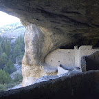
7. GILA
COUNTRY & THE CONTINENTAL DIVIDE
NM 15 near Gila
Hot Springs to Monticello Canyon Middle
& East Fork Gila River, Tom Moore Canyon, South Diamond Creek, east to the
Continental Divide on the Black Range Crest, then north to Wahoo Peak, and east
to Monticello Box and Alamosa Creek.
Guidebook: Segment 22 |
23 | 24
| 25 | 26 | 27 |
| | | |
8. SAN
MATEO & MAGDALENA MOUNTAINS
Monticello Canyon to
US 60 at Magdalena San
Mateo Mountains, Apache Kid Wilderness, Withington Wilderness, east to Milligan
Hills, and north along the crest of the Magdalena Mountains to the town of Magdalena.
Guidebook: Segment 28 | 29 | 30
| 31
|
| | | |
9. RIO
GRANDE VALLEY & CHIHUAHUAN DESERT
Magdalena NM to
US 60 west of Mountainair Towns
of Magdalena and Polvadera, San Lorenzo Canyon, the Rio Grande valley, and the
Chihuahuan Desert region south and east of Sevilleta National Wildlife Refuge.
Guidebook: Segment 32 | 33
|
| | | |
10. MANZANO
& MANZANITA MOUNTAINS
US 60 west of Mountainair
to Route 66 at Tijeras Manzano
Mountains, the Manzano Mountain Wilderness, Crest Trail, and across the Manzanita
Mountains & Cedro Canyon, north to Historic Route 66 at the village of Tijeras.
Guidebook:
Segment 34 | 35 | 36 | 37 |
| | | |
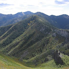
11. SANDIA
MOUNTAINS & SANDIA CREST
Route 66 at Tijeras to
GET east terminus at Albuquerque Sandia
Mountain Wilderness & Sandia Crest, La Luz Trail, and the Tramway Trail to
the GET eastern terminus at Albuquerque.
Guidebook: Segment 38 | 39 |
| | |
| 12.
G.E.T. COMMUNITY
GALLERY
An
ad hoc collection of images & video from the Grand Enchantment Trail, as documented
by the trail community. To have your GET photos added to the Community Gallery,
log into your Google account and then click the Add to Album icon on the Community
Gallery page. Please include your name if you would like credit for your work.
A caption or comment describing the location of your photo (where and when) is
also helpful. | |