G.E.T.
Guidebook
Segment 1: Superstition Wilderness 30.3
miles  Guidebook
Home Guidebook
Home
Open
this page for printing
Submit
feedback for this segment
|
Segment
Length |
Segment
Status | Season |
|
|
|
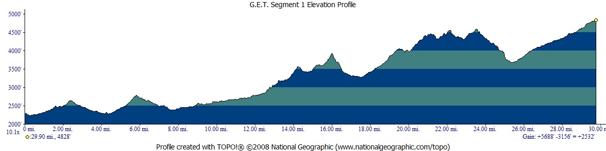
30.3
mi. | finalized
& accessible | fall,
winter, spring | | Resources |
| OVERVIEW
MAP | 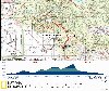 |
| ELEVATION
PROFILE | 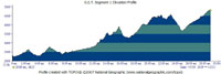 |
G.E.T. Topo Maps 1-4
Town Guide: Phoenix
Water Chart
Image Gallery: Album 1
| Additional
maps:
Tonto
National Forest (USFS)
Superstition Wilderness (USFS)
Land managing agency:
Tonto N.F. Mesa Ranger District |
| Beginning
access point | | Ending
access point | |
Forest Route 78 at Dutchman
Trail #104. First Water Trailhead is accessible by 2WD passenger vehicle.
See Town Guide for directions to here from downtown Phoenix and Apache Junction. | |
Trail #109 at Forest
Route 172A. Rogers Trough Trailhead is accessible by 2WD high-clearance vehicles
in dry weather, otherwise 4WD required. Two miles east of Florence Junction, turn
north off US 60 onto FR 357, to FR 172, then right on FR 172A. Bear left at jct
with FR 650 and continue short distance to trailhead, appx. 14 mi. from US 60. |
SEGMENT
OVERVIEW The
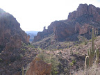
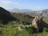
Superstition Wilderness of Arizona's Tonto National Forest encompasses a unique,
diverse, and dramatic landscape of canyons, mesas, and volcanic peaks, much of
it occurring in the lower and upper Sonoran desert life zones with their equally
unusual communities of plant and animal life. As such, this segment is truly a
feast for the senses, a fitting place to begin or end an extended journey on the
Grand Enchantment Trail. Our
route follows an extensive and meandering network of foot trails, varying in condition
from well-trod and easily followable, to vague and overgrown in places. In general,
the trail sections nearest the major trailheads (First Water, Peralta, and Rogers
Trough) receive the most use and are maintained accordingly (either officially
so or by virtue of all the foot and hoof traffic). Farther in the backcountry,
where comparitively few users go, trail conditions tend to be more rough, and
unavoidably overgrown with catclaw and other bushes, at least in corridors here
and there. Overall, the terrain in this segment is quite rocky and rough, with
a fair amount of climbing and descending as the trails negotiate passes between
the many steep-walled canyons for which the "Supes" are renowned. For long-distance
hikers just starting out, rest assured: While the way may seem difficult, and
indeed it is unavoidably so here, the rewards are yet evident all around, and
the route does become somewhat easier once it joins the Arizona Trail near the
eastern end of this segment and continuing into segment 2. With
the exception of two generally reliable water sources (Charlesbois Spring and
La Barge Spring), water can be rather scarce in dry times, so be sure to carry
enough of it despite the extra packweight. Impromptu campsites are encountered
with some frequency along the way, and the going at either end of this segment
can sometimes get a little crowded, but for the most part hikers can expect a
wilderness experience with plenty of solitude among these mystical and legendary
desert hills.
ROUTE
DETAILS First
Water Trailhead may be approached via dirt FR 78, or on foot via a spur trail
(signed Dutchman Trail) that parallels this road from First Water equestrian parking
less than half a mile to the west. A self-service pay station is here - required
only if parking a vehicle. (The Forest Service had waived the parking fee as of
spring 2007.) First Water Trailhead (no water available) also has restrooms, an
information board, and a trailhead register. The
Grand Enchantment Trail begins on Dutchman Trail #104, which heads east beyond
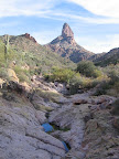
the register and immediately enters the Superstition Wilderness. Distant Weaver's
Needle is just visible above nearer peaks as the wide trail descends gently to
a junction with Second Water Trail #236 at 0.3 miles. Turn right here,
staying on Trail 104, soon reaching a side drainage, then crossing usually-dry
First Water Creek several times in the company of some intriguing cliffs of welded
volcanic ash (tuff). The trail climbs gradually, reaching a low pass and then
higher Parker Pass at 2.5, a scenic place for a rest break. Descending
east, the trail jogs briefly north at an old junction, then turns east again to
cross the wide wash of West Boulder Creek at 3.7. A campsite is located
on the right, just beyond the braided wash. Weaver's
Needle reappears to the south as Trail 104 reaches a junction with Black Mesa
Trail 241 at 4.3, then turns south toward junctions with Boulder Canyon
Tr 103 and Bull Pass Tr 129 in quick succession. Trail 104 now enters dramatic,
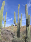
saguaro-studded East Boulder Canyon, often with pools of water available about
half-way up, the presence of which may be heralded in early spring by the staccato
call of canyon tree frogs. Pass Peralta Canyon Tr 102 on the right. Pay attention
at 5.4 (mapset waypoint 01070) - here our Trail 104 leaves the drainage
to the left at a vague, unsigned junction. (A de facto path continues straight,
soon emerging into an open area that has been overcamped in the past.) Our Trail
104 climbs the canyon's east side via a long switchback. The trail reaches Upper
Black Top Mesa Pass, then descends east to a signed junction with Terrapin Trail
#234 at 6.4. Continue straight, remaining on Dutchman Trail 104. Soon
pass a mediocre campsite on the right, then cross the drainage of Needle Canyon.
Trail 104 now turns north and briefly enters a "rock garden" with large,
overhanging boulders that provide welcome shade. The trail remains close to the
drainage on its east side, possibly with pools or flowing water available in wetter
times, then heads across an open flat to a signed junction with Bull Pass Trail
129 at 7.4. (Bull Pass Trail heads west, climbs and descends steeply over
its namesake pass, then returns to the Dutchman Trail near MP 4.6in this segment.)
Remain on Trail 104, now heading east. Look back for final views of Weaver's Needle
as the trail contours and descends toward La Barge Canyon, en route passing a
junction with Cavalry Trail 239. Trail
104 reaches the wide, sandy bottom of La Barge Canyon at 7.7 (waypoint
01100), and turns right, south. The trail keeps to the west side of the wash,
soon passing a good campsite on the left. After more than a mile, the trail crosses
the drainage, with good views north back toward the weathered volcanic cliffs
of Black Mountain, then reaches an unmarked junction at 9.0 (waypoint 01110).
Here our Trail 104 turns right, while a side trail continues straight (east) toward
Charlesbois Spring, where it ends. The spring
(in true Old West tongue-in-cheek style, pronounced "Charlie Boy") is
a surprisingly deep pool (sometimes a series of pools) located in the shady drainage,
often algae-covered but considered to be reliable even in dry times. Trail
104 proceeds south, climbing somewhat and passing a junction with Peters Trail
105 on the left. Our trail remains above the scenic, saguaro-flanked drainage
of La Barge Canyon initially, then dips to cross it a few times, along the way
entering a lush area of sycamores and sugar sumac with camping available. A final
wash crossing and brief climb lead to a signed junction with Red Tanks Trail 107
at 10.3 (waypoint 01140). Here, turn left onto Trail 107, leaving Dutchman
Trail 104. La
Barge Spring is located in a lush riparian area to the left a short
distance ahead, with a couple of potential campsite nearby. Look (and listen)
for the spring near the base of the steep embankment across the drainage. Climb
the bank to reach the spring trough, a convenient place to fill your bottles.
The spring must emerge from the cliff face not far above the trough. Occasional
cairns guide the way as Trail 107 - which sees less use than the Dutchman Trail
- meanders back and forth across the creekbed in Red Tanks Canyon, reaching a
junction with Whiskey Springs Trail #238 at 12.3. Turn left, remaining
on Trail 107 and soon entering narrow and dramatic Upper La Barge Box. The trail
crosses the rocky drainage to its right (south) side, sometimes with pools of
water nearby, then after an awkward little climb returns to cross the drainage
once more to its left side. At this second crossing, look carefully for cairns
leading the way ahead and do not continue up the drainage itself by mistake. The
trail climbs steeply away from the drainage on its north side, then contours eastbound
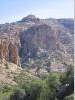
along the flank of the rugged canyon to its head. The Box, flanked by tall rust-colored
volcanic cliffs and densely vegetated with saguaro cactus, is especially impressive
when carpeted in wildflowers in the early spring of wet years. Beyond
the box, at 13.9, Trail 107 continues straight while our route now turns
left (north) onto Hoolie Bacon Trail #111. This trail climbs somewhat vaguely
among prickly pear then descends a bit into the shallow head of Trap Canyon, with
a few shady camping possibilities among the junipers. The catclaw in this area
can be rather bad in places, especially following a wet spring and summer. The
overgrowth, compounded by the presence of several beaten paths in this area, may
briefly confuse the way ahead. Be especially careful to avoid continuing straight
up the drainage at waypoint 01200 onto an abandoned trail. Our Trail 111 turns
right here, possibly as indicated by a small cairn, climbing away from the drainage,
as shown on the map. The long undulating climb, through Horse Camp Basin and beyond,
rewards with spectacular views at a pass along Horse Ridge at 16.3, (waypoint
01210) from which the prominent Four Peaks are visible to the north, at the southern
end of Arizona's Central Highlands region. The trail proceeds down the other side,
steeply and among loose rock at first. It passes near the dry cement tank of Nighthawk
Spring, then enters the canyon basin of Tortilla Creek. Just after crossing a
minor wash, the trail enters a little flat and briefly becomes vague. Here turn
left, possibly following cairns a short ways, and paralleling the wash you just
crossed. Our trail soon joins up with the main drainage of Tortilla Creek (which
sometimes has pools), heading northbound. Eventually the trail crosses to the
right side of the drainage, then leaves it. A brief ascent leads to a junction
with JF Trail #106 on a wide open flat (18.4, waypoint 01220).. The 4WD-accessible
Tortilla Well trailhead lies a mile or so north of here. From
the trail junction, turn right, south, onto Trail 106. Our route climbs gradually
along a wide ridge, now in the somewhat cooler, Upper Sonoran life zone. After
a mile or so it begins to contour, occasionally descending, and reaches a small
drainage containing Clover Spring at 20.5.
A small campsite is here, and in wetter times, a few pools in the potholed drainage
a short ways below the trail crossing. (More pools may be found about 0.1 mi.
farther down the drainage.) Beyond, Trail 106 resumes its meandering climb, becoming
increasingly hard to follow in places and requiring that one remain attentive
to small, impromptu cairns along the way (especially when heading the other way,
it seems, although individual routefinding challenges tend to be isolated and
short-lived). The trend toward gains in elevation ends abruptly at 22.7,
as Trail 106 now drops steeply to the east side of the ridge, passes through an
area rather overgrown with mountain mahogany, and levels out a bit near the head
of Tortilla Creek's drainage (waypoint 01250). Watch carefully for the vague trail
as it forks left, bending around to the east. (The right fork may lead west
into the upper drainage of Tortilla Creek, from which a side trail may then lead
south to Mullin Spring, as shown on the topo map, but this is unverified.)
Thicket-strewn Trail 106 then resumes climbing to top out at a ridgecrest trail
junction by an old corral at 23.7 (waypoint 01260). A good dry camp could
be made here. From
the corral and trail junction, the JF Trail 106 continues right, while our route
turns left, north, onto Rogers Canyon Trail #110. This trail is in better shape
here, and soon climbs to viewful Tortilla Pass (4600'), (a small campsite is just
off to the left [west], unseen from the trail) then contours downhill before a
final switchbacking descent into the prominent drainage north of the pass. Trail
110 - still with discernable tread - now follows the brushy, overgrown drainage
down to its mouth at 25.9. Welcome to Angel Basin, a beautiful (and much-enjoyed)
grassy meadow with shade trees, ample camping opportunities, and sometimes water
in Rogers Creek. Frog Tanks Trail #112 heads
left here, while we continue straight ahead on Rogers Canyon Trail 110, a boulder-strewn
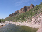
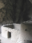
affair in this part of the canyon, hemmed in by sheer cliffs. Rogers
Canyon Cliff Dwelling is soon visible across the drainage on its south-facing
exposure. This small but remarkably well preserved site was home to a small Salado
Indian community 700 years ago, and is well worth the short scramble to see it
up close. (The more difficult to reach alcove at left contains an intact structure.)
Beyond, our trail parallels and occasionally follows the rockbound drainage of
Rogers Canyon, pleasant in its setting of shady live oaks. Trail 110 ascends gradually
south, crossing back and forth. It passes an obvious campsite on the right, (and
several that are less obvious, across the drainage on its east side) then finally
leaves the drainage on its left bank to end at a junction with Reavis Ranch Trail
#109. Here, at 28.7 (waypoint 01280), the Grand Enchantment Trail joins
the Arizona Trail southbound by turning right onto Trail 109. (Left, northbound
on the AZTrail/Tr109, leads in about a mile to the gravesite of Elisha Reavis,
the famed "Hermit of the Superstitions," which may require some effort
to locate.) Following
the Arizona Trail / Reavis Ranch Tr 109 south - well used and better maintained
- our route returns to the banks of Rogers Creek, occasionally crossing it, then
climbs to a more open area near 29.9, where the trail passes through a
wire gate. If the creek hasn't been flowing, you may at least find pools
of water in the drainage near here. West Pinto Trail #212 (signed)
heads sharply left near 30.1, (westbounders, turn left onto Tr 109) - not
our route, but worth following for a quarter mile or so if you need water, as
Rogers Spring (shown on maps, located near
trailside on the lower slopes of Iron Mountain) is reportedly more reliable than
the drainage of Rogers Creek. Meanwhile, our Trail 109 continues south, soon ending
at the large dirt parking area of Rogers Trough Trailhead at 30.3 (waypoint
02010), just outside the boundary of the Superstition Wilderness.
|