G.E.T.
Guidebook
Segment 22: Middle & East Fork Gila River 24.8
miles  Guidebook
Home Guidebook
Home
Open
this page for printing
Submit
feedback for this segment
|
Segment
Length | Segment
Status | Season |
|
|
|
24.8
mi. | finalized
& accessible | spring,
summer, fall | | Resources |
| OVERVIEW
MAP | 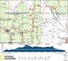 |
| ELEVATION
PROFILE | 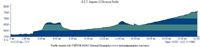 |
G.E.T. Topo Maps 60-62
Town Guide: Gila Hot Springs
Water Chart
Image Gallery: Album 7 |
Additional maps:
Gila National Forest
(USFS)
Gila Wilderness (USFS)
Land management agencies:
Gila
NF Wilderness Ranger District
|
| Beginning
access point | | Ending
access point | |
NM 15 at Gila Cliff Dwellings
contact station. From
Silver City NM, follow NM 15 north (narrow and winding, with some steep grades*)
43 miles to t-junction and turn left, remaining on NM 15. Parking is available
at TJ Corral trailhead on the right in 0.8 mi. (access to Seg 21 Highwater Bypass
trail network). Otherwise continue additional 0.8 mi to Gila Cliff Dwellings contact
station and parking for West Fork at start of Seg 22.
Alternate beginning
access point avoiding 2.1 mi paved roadwalk at start of Seg 22, instead
continue straight (north) at aforementioned t-junction, passing Gila Cliff Dwellings
Visitors Center (water/restroom) to small lot at trailhead for Middle Fork Trail
157.
*Those wishing
to avoid mountainous portions of NM 15 can instead use NM 35: turn north onto
Highway 152 from Highway 180 at Santa Clara, NM. Follow 152 to the junction with
35 and follow 35 to the junction w/15. | |
FR 150 at Trail 707 trailhead.
Join NM 35 north
per Beginning Access Point "asterisked" directions. Follow NM 35 past
community of Mimbres to Mimbres Ranger Station and continue ~5 miles to signed
turnoff for FR 150 (North Star Road) on right. Follow graded dirt FR 150 (can
be rough in places, with several long grades) approx. 24 miles to Alternate
ending access point at trailhead for Trail 708 by old corral on left
side of road, at MP 22.3 of this segment. Or continue on FR 150 1 mile farther
via continuation of GET route in this segment, and turn right on signed 2WD FR
61 to Me Own fire/helitack site. Follow road clockwise around admin. site building
and pass through gate by corral (toilet and water spigot nearby). Continue via
2-track 0.25 mi. to small turnout by Aldo Leopold Wilderness boundary at Trail
707. | PLEASE
NOTE: THIS CHAPTER REMAINS UNFINISHED. SEGMENT OVERVIEW AND ROUTE DETAILS INFO
BELOW ARE IN DRAFT FORM AND HIGHLIGHT ONLY THE ESSENTIALS NEEDED FOR NAVIGATING
THIS SEGMENT IN CONJUNCTION WITH THE TOPO MAP SET. SEGMENT
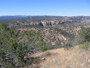
OVERVIEW Brief
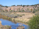
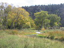
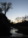
encounters with scenic canyons of Middle and East Fork Gila River early in segment.
Lightfeather Hot Spring en route. Six fords of Middle Fork, knee-thigh deep in
spring, gentler/lower by autumn; convenient, short bypass route available during
times of high water. Single ford of East Fork basically unavoidable - gentlest
of three Gila forks, generally quite shallow, rarely problematic. Canyon of Diamond
Creek beyond involves a few dozen fords of minor creek. Brief x-c to little-used
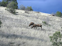
pack trails in juniper-ponderosa parks - prime elk habitat - culminate in extended
walk up mellow Tom Moore Canyon, often dry except for likely-perennial slot canyon
portion of drainage below route. FR 150 divides Gila Wilderness and Aldo Leopold
Wilderness - a quiet walk with no useful hitchhiking prospects except in an emergency
(to NM 35 - Lake Roberts or Mimbres, etc).
ROUTE
DETAILS Upper
& Lower Scorpion camp/picnic grounds along NM 15 within the first half mile
of this segment intended mainly for car campers. Lower Scorpion has short interpretive
trail leading to interesting pictographs, as well as a separate, small dwelling
or granary in a side canyon. Community
of Gila Hot Springs is 3 mile walk S via NM 15 from MP 1.6. Doc Campbell's
Post first business on left. Free camping available on FS land, S side of hwy
before reaching town, along Little Creek -
find use trail on E side of hwy bridge over creek. Gila
Cliff Dwellings NM visitor's center has developed water,
restrooms, pay phone, picnic table. Middle Fork Trail 157 trailhead at 2.1. Middle
Fork Highwater Bypass: If Middle Fork Trail 157 has problematic first ford,
backtrack to trailhead and turn left, continuing up road into vehicle-restricted
area. Unsigned trail begins at small horse corral on left - pass through corral.
Climbs ridge to mesa, then turns north. (Westbounders ignore left fork at
unsigned junction before descending off mesa.) Rejoin main route at trail
sign at 4.4 (continue straight). (Westbounders, watch for
signed junction, and turn right to remain on main route, or keep straight to follow
Highwater Bypass.)
Six
fords of Middle Fork Gila River on main route.
Trail 157 flood-damaged 2012 but our brief section remains relatively easy-going.
Way ahead is usually obvious / beaten down, and any flood debris easily circumvented.
Lightfeather Hot Spring located at trailside. Signed trail to North Mesa and White
Rocks at 3.5 (waypoint 22050). Initially steep, rough, then mellows on
bench. Left at junction at 4.4 (Highwater Bypass ends here northbound).
Rocky switchbacking ascent to North Mesa. Trail sign at 5.5;
bear right at fork here onto Trail 804 (don't continue to White Rocks).
North Tank is unreliable stock
pond skirted by trail. Steep, rocky descent off mesa on cairned trail; Adobe
Spring often dry where first encounter drainage, but pools sometimes
present lower down. Trail here to waypoint 22100 features tread maintenance (2013?)
and easily followable. Turn right (south) at junction (waypoint 22100) following
de facto trail along W side of East Fork Gila River (continuation of Tr 804, not
on route, unsigned, reaches cairn at Gila River, then vague). (Westbounders
turn left (west) up obvious drainage of Adobe Canyon at 8.8.) Single,
easy ford of East Fork Gila River. Nearby
cottonwoods, camping. Trail becomes vague but bears east through wire fence opening
in old corral (faint) near 9.2. Another trail may remain with
East Fork, but beaten path usu. continues east with drainage of Diamond
Creek. (Westbounders, don't continue with Diamond Creek all the
way to confluence; bear west across open meadow to pass through old wire fenceline/corral.)
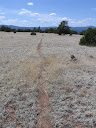
Social trail in Diamond Creek canyon, unnamed/unsigned but look for where any
recent pack animals have beaten down vegetation; sometimes overgrown with grasses
by autumn and basically cross-country, but navigation remains obvious. Diamond
Creek flow more reliable farther up drainage; travel easier; fords frequent but
shallow/gentle. Good camping prospects. After
temporarily exiting Gila Wilderness at 12.5 (waypoint 068) (old fence across
drainage now falling down; gate along N bank), watch for first flat-floored side
drainage on right and turn up it, x-c, with short easy pour-offs/steps. Eventually
becomes wide, sandy wash. At 14.1 or just before, note trail
on right (south) leading up side drainage - unsigned Trail 713. Keep straight
at next unmarked junction (waypoint 22155), ascending minor ridge. Bear right
at next junction on ridge (waypoint 22160) and DO NOT follow the more obvious
trail left (if you find yourself heading east at all, then you missed this junction
and are on the wrong trail). Trail 713 now descends a little to the head of unnamed
drainage, then turns left (southwest) down it at 15.3. Reaches confluence
of drainages at dry Long Canyon Tank at 16.2 (former stock impoundment).
Continuation of Tr 713 per base map data unfollowable. Instead, keep right (west)
of tank and follow down drainage with vague tread. Keep an eye out for trail that
bears sharp left, crossing drainage to south side (waypoint 22190) and DO NOT
continue straight toward another network of drainages. Our trail climbs southeast
over grassy bench to Tom Moore Canyon. If no water in drainage just below trail,
continue down it x-c somewhat roughly to start of slot portion within half mile
for likely pools. Slot is non-technical but
difficult farther down, esp. on return up canyon. (Westbounders, after passing
Middle Tom Moore Well/broken windmill, then old corral, look for vague trail,
cairned in 2010, slabbing west-northwest out of canyon among grasses and don't
continue on Trail 708 (you may note a 2010-installed signboard), nor in drainage
except in search of water.) Trail
708 in Tom Moore Canyon easy and straightforward, with camping, but dry except
for small seasonal impoundment (no cows) north
side of trail, west of 21.8. Exit Gila Wilderness for good at
22.4, which is second of three fencelines/gates between the impoundment
and trailhead. Trail becomes old 2-track approaching trailhead. FR 150 graded
2WD, but very light vehicle use. Turn right at road sign onto FR 61 to Me Own
fire/helitack site. Ignore sign for Trail 707 at cattle guard and continue on
road, clockwise around modular building / fire base (westbounders counter-clockwise).
Vault toilet here by corral with spigot. Pass
through gate and continue on 2-track road to Aldo Leopold Wilderness boundary
at trailhead turnout. |