Adventure
Awaits... Adventure
Awaits...
on the Grand Enchantment Trail
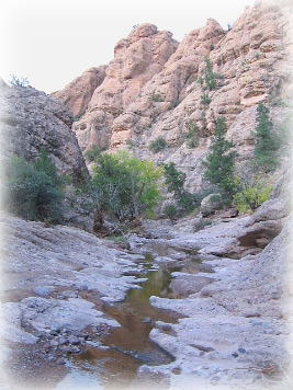 |
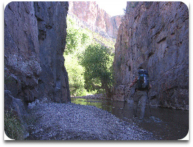
| Canyon
of Turkey Creek, Galiuro Mountains | The
G.E.T. offers a wild, scenic, diverse, yet also convenient way of discovering
some of the most fascinating and little-known corners of the American Southwest. First
conceived in 2003, the Grand Enchantment Trail (GET) is today a proven, navigable
route from end to end, over 770 miles in total across Arizona and New Mexico.
Primarily described by map and guidebook, the route links existing hiking trails,
dirt roads, drainage courses, and occasionally runs cross-country, providing an
adventurous, rewarding, and highly varied hiking (non-motorized travel) experience
that nonetheless feels natural and fluid like a more traditional long-distance
trail.
Access and Opportunity Many
aspects of the Grand Enchantment Trail are unique to distance hiking, but perhaps
none more than the locations of its termini. The GET begins and ends at the edge
of large urban areas - Phoenix in the west and Albuquerque in the east. This
allows unparalleled ease of access, yet without diminishing the wilderness experience
in any way. National Forests touch the boundaries of both cities, and hikers
find themselves out of civilization's grasp less than an hour from downtown.
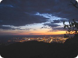 |
| Albuquerque
at dusk, from Sandia Crest | While
the vast majority of the GET explores remote wilderness areas, it also reaches
small towns along the way, where travelers may rest and provision themselves for
the journey's next leg. Groceries and restaurants offer much sought-after calories,
and post offices hold maildrops for hikers as on other long-distance trails. These
"trail towns" are located at convenient intervals along the route, allowing
hikers to carry less packweight and to focus on the wonders of the natural world.
(See Town Guide)
GET
 Number of on or near-route resupply points: 13
FACTS
Longest distance between resupply points: ~90 mi. |
Over 770 Enchanted Miles from End to End
The
airline distance between Phoenix and Albuquerque is only 300 miles. Clearly the
Grand Enchantment Trail does not make direct passage between its end points,
but instead follows a route designed around the journey. (See overview
map) What may be lost in sterile efficiency is more than recovered in enjoyment:
the trail passes through some of the most scenic, well-watered, and diverse environments
- ecologically, culturally and geographically - that exist in this region.
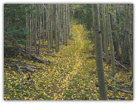 |
| Manzano
Crest Trail | The
Grand Enchantment Trail differs from most other long-distance trails in that it
does not at present use
a single mile of trailway built specifically for its purposes. Although increasingly
familiar to land management agencies, whose trail maintenance efforts portions
of the route will surely benefit from, nevertheless the GET does not possess any
official sanction. This, in fact, offers several distinct advantages. Because
the GET is a free route, distinguished by its impermanence on the land, it is
not so at the mercy of politics. Instead it is free to wander the backcountry,
to be adapted as circumstances or preferences allow, all the while making efficient
use of the existing trails, primitive tracks, and public lands that occur abundantly
throughout the states of Arizona and New Mexico. In fact, the Grand Enchantment
Trail already utilizes significantly more trail tread than
does the Continental Divide Trail in New Mexico, a route that has been in development
for many years. (View GET
Surface Types map)
| Mileage
by Surface Type | | Foot
Trail | 425 |
56% |
| 4WD
dirt | 145 |
20% |
| 2WD
dirt | 85 |
11% |
| X-country |
85 |
11% |
| Paved |
30 |
2% |
| Total
770 | How
much trail? A
bit over 400 miles of the GET is hiking trail at this time - nearly 60% of the
route. The majority of these miles are part of the US Forest Service's trail system,
and vary in condition from well-maintained and obvious to relict and vague. An
ongoing focus of the GET project is to push for rehabilitation of overgrown or
otherwise time-weary sections of trail in order to smooth travel along certain
portions of the route. Ruggedness and challenge are essential components of the
experience, however, and hikers should bring with them a familiarity with wilderness
travel, map and compass skills, as well as the use of GPS. As
for its other miles, many are routed along primitive 2-track roads which are often
closed or largely impassable to vehicle traffic, but remain ideally suited for
travel on foot. Hiking here is generally straightforward. Maintained Forest Service,
BLM, and county roads offer easier walking still, and some are graded for passenger
cars. Traffic, even along the very occasional paved road surface, tends to be
light throughout. Where
trails and roads do not offer an efficient link, the GET sometimes opts to travel
overland. Most such segments are short, direct, and obvious with due care. Box
canyons, many with flowing water, offer rugged yet straightforward passage, as
do the sandy bottoms of desert washes and arroyos. Dirt roads can be linked together
in open country by following a compass bearing or line of sight, traveling cross-country
among the greasewood or pinyon-juniper.
GET
Longest continuous
distance away from paved roads: 186 miles
FACTS
Route does
not join pavement from Gila Cliff Dwellings to the town of Magdalena
  A
Bridge Between Trails A
Bridge Between Trails
The
Grand Enchantment Trail also uses segments of the Arizona Trail (AZT) and
Continental Divide Trail (CDT) on its way from end to end. Approximately
70 miles of the GET coincides with the Arizona Trail across the Sonoran desert,
as well as 45 miles of the CDT in New Mexico's remote Black Range. Both the AZT
and CDT offer distinct experiences of their own, and the GET weaves a portion
of these into its own unique perspective.The Grand Enchantment forms a bridge
between long distance trails, even facilitating a great circuit hike of several
thousand miles throughout the American West (with the PCT and PNT, the "Great
Western Loop").
An Oasis in an Arid Land
The
Southwest is arid country, no question about it. Much of the region is desert,
and even the highest mountain summits receive less precipitation annually than
in other parts of the US. Despite this, the Grand Enchantment Trail encounters
water sources with surprising frequency over its full length. (See Water
Chart) Part of the criteria used in developing the route was to find a way
of minimizing the burden in water weight typical of arid-land hiking. Indeed,
spring season hikers can often expect to find multiple sources of drinking water
each day of the journey, and rarely if ever would carry more than a day's supply
at a time. Typical sources include mountain and canyon creeks, snowmelt, desert
springs, and piped groundwater such as windmills and stock troughs. Most water
is of fair to excellent quality.
 |
| Aravaipa
Canyon | Notable
among the route's watery reaches is its abundance of truly outstanding desert
and montane canyon environments. Aravaipa Canyon, a renowned riparian canyon
ecosystem, is located along the GET, as are the picturesque and sometimes dramatic
canyons of the Gila River, Blue River, San Pedro River, Eagle and Bonita creeks,
and Monticello Box. Not only do these perennially flowing watersheds provide an
oasis for hikers, they are also home to a rich diversity of plant and animal life.
Pools of water also appear in occasional slot canyons along the way. Non-technical
in nature, these narrow defiles are remarkable both for their rugged beauty as
for their near total obscurity in spite of the former.
GET
Number of potential
water sources along the route: 170+
FACTS
Total hiking
miles alongside creeks and rivers: 90
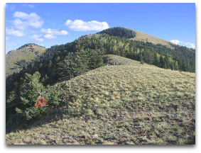
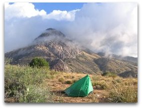
14 Mountain Ranges
The
GET traverses at least 14 distinct mountain ranges, and passes in the shadow of
many more solitary peaks and cliffs. (See elevation
profile) Some ranges are low and arid, but often with stark and dramatic relief,
while others rise much higher where they penetrate any storm clouds, providing
sufficient moisture for coniferous and aspen forests. Many of the mountain ranges
encountered show aspects of both desert and montane ecosystems. Among these are
the aptly-named "sky island ranges," such as the Pinalenos, whose
lofty crests rise like islands above a sea of desert. These ranges are exceedingly
diverse, both climatologically and biologically, and in some cases harbor virtually
every life zone - the equivalent of what one might see on a walk from Mexico to
Canada.
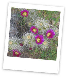 |
| Hedgehog
cactus bloom |
Uncommon Deserts By
way of its east-to-west orientation, the Grand Enchantment Trail explores both
the Sonoran and Chihuahuan deserts, as well as transitional environments
between and beyond the two. It is the only long-distance route in the US to
visit both of these "wet" deserts, which receive more rain annually
than any other desert in North America. Owing as well to its warmth, the Sonoran
desert is home to a fascinating and unusual assortment of life forms, including
the stately saguaro cactus, fishhook barrel, and bizarre whip-like ocotillo. The
Chihuahuan desert is higher and cooler. Here, agave and yucca grace the open plains
with their spikey clusters and waving stalks, while fragrant greasewood lend hillsides
a soft grey-green hue. Semi-arid grasslands and pygmy forests of pinyon and juniper
occur at elevations just above the desert, offering charms all their own.
GET
Miles of desert
or semi-arid hiking between termini: 495
FACTS
Miles of hiking
beneath forest cover: 275
12 Forever Wild Regions
The
Wilderness Act of 1964, implemented by US Congress, mandates the long-term protection
of undeveloped natural areas determined to possess greater value - biological,
scenic or recreational - in their own right than might be realized in some other
sense through their exploitation. These Wilderness Areas are the crown jewels
in America's public lands system, the few remaining places in our country where
"man himself is but a visitor, who does not remain." Here we may hike
and camp in relative isolation from the tiresome machinery of modern living, and
experience nature more on its own terms.
| WILDERNESS
AREAS (with managing agency) | | Arizona |
New
Mexico | | Superstition
(USFS) | Gila
(USFS) | | White
Canyon (BLM) | Aldo
Leopold (USFS) | | Aravaipa
Canyon (BLM) | Apache
Kid (USFS) | | Santa
Teresa (USFS) | Withington
(USFS) | | Gila
Box NCA (BLM) | Manzano
Mountain (USFS) | | Blue
Range P.A. (USFS) | Sandia
Mountain (USFS) | | Wilderness
is where the magic happens, and the Grand Enchantment Trail affords access to
wilderness in abundance. In fact, nearly 200 miles, or about 28% of the GET
lies within officially-designated Wilderness. (And a great deal more of the
route is wilderness by every outward appareance.) Many of these wilderness areas
are under the stewardship of the US Forest Service, and in no case is a permit
required to hike here. In several instances, the Bureau of Land Management oversees
federally-designated wilderness - often a rugged and picturesque canyon environment
- and in one such area (Aravaipa Canyon), visitors must obtain a recreation permit
in order to hike and camp - the only "red tape" to be found along the
entire trail.
National Monuments, Ancient Treasures
The
Southwest is archaeologically rich, with a staggering number of significant cultural
sites located throughout the region. Among the best preserved Native American
architecture to be found here is at the Gila Cliff Dwellings, in southwest
New Mexico, and Salinas Pueblo Missions east of the Rio Grande, both now
protected as National Monuments and located near the route of the Grand Enchantment
Trail.
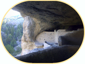 | |
Gila Cliff
Dwellings National Monument | Gila
Cliff Dwellings National Monument features a remarkably well preserved 13th century
Mogollon community built within large natural alcoves along a sheer rock face
- stunning both to behold and to explore up close. View examples of Pueblo and
Spanish architecture at the 16th century ruins of Salinas Pueblo Missions National
Monument. Located near the trail, the monument's Abo district features the tall
and impressive remains of a Pueblo community later influenced at the hands of
Spanish missionaries. Many
traces of indigenous cultures lie elsewhere along the Grand Enchantment Trail
as well. Seek, and you may find...
Ghost Towns and Boomtowns
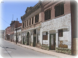 |
| Chase
Creek Street in Clifton | The
Old West is alive and well here too. Nineteenth and early 20th century mining
towns came and went. Some, like Kelly New Mexico, went bust for good, while
others proved too tough to die. Or too charming: the ghost town of Mogollon
sits high in a rugged, forested canyon near the route, its period homes, saloons,
and other architecture now attracting artists and curious travelers from around
the country. Mining
also lays claim to the New West, and continues to form the backbone of small town
economies. Just uphill of historic Clifton Arizona, the enormous open pit of Morenci
continues to yield more copper than any other mine in North America. The town
of Morenci, like the mine, is a world unto itself that few outsiders see, and
the GET offers the curious traveler a glimpse.
| Watchable
Wildlife | | >
rocky mtn. bighorn sheep |
| >
collared peccary |
| >
white-nosed coati |
| >
mexican gray wolf |
| >
great blue heron |
| >
blacktail rattler |
| >
rocky mountain elk |
| >
mt graham red squirrel |
| >
whooping crane |
| >
gila monster |
| >
elf owl | | >
coues whitetail deer |
| >
ringtail cat |
| >
desert tortoise |
| >
gila woodpecker |
| >
desert pronghorn | |
Unique
Wildlife Few
long distance trails offer as much diversity of wildlife as the Grand Enchantment
Trail - particularly of uncommon wildlife, from the curious to the breathtaking.
 |
| Gila
monster | In
the deserts and canyons of southeast Arizona, hikers are likely to encounter pig-like
javelina foraging on the pads of prickly pear, or spot a black and orange
lizard, the gila monster, crawling dinosaur-like along a sandy wash. Coatimundi
- looking like one part bear, one part raccoon - forage for manzanita berries
in forested canyons of the Sky Island ranges, while ringtail cats scurry among
desert boulders under cover of darkness. Majestic bighorn sheep mingle
among the high cliffs above Eagle Creek or stroll nonchalantly across traffic
in Morenci.
 |
| desert
tortoises | Farther
east, in the remote Gila country of New Mexico, the endangered
Mexican gray wolf roams free once more, hunting for rocky mountain elk,
mule deer and gray fox among the ponderosas and pinyon pines. Black
bear and cougar live here as well; campers
have an excellent chance of hearing the haunting cry of a mountain lion in the
night. Pronghorn antelope travel fleet-hooved in cautious herds across
the open plains, while along the Rio Grande flyway, the magnificent wingspan of
whooping cranes spreads out across the New Mexican sky once again.
Unlimited
Opportunities
 |
| Santa
Teresa Wilderness | The
Grand Enchantment Trail offers truly unlimited opportunities for exploration,
adventure, and solitude. For those who hear its call, this extraordinary route
will reveal a cross section of the American Southwest unlike any other, one of
stunning diversity in landscape, flora, fauna, and culture. Whether taking to
the trail for an afternoon, the week, or a two month thru-hike, you'll find the
GET has much to offer of a genuinely grand and enchanting place. Here, unknown
to many, lies a land still wild and worthy of preservation; come see this land,
to revel in it, and ultimately, to ensure that its beauty endures.
|