 Snow
Travel
Snow
Travel Spring
season hikers may occasionally encounter snowpack in forested terrain above 8000
feet in elevation. Although a potential concern over only a limited portion of
the full route, this residual winter snowpack can occasionally be deep and prevalent
enough to warrant careful consideration before attempting to negotiate it.
In
heavier snow years, the best strategy may be to delay the start of your thru-hike
in order to allow the snowpack more time to coalesce and melt, which will decrease
both its depth and area of coverage, making any snow travel less laborious and
time consuming. Consider starting eastbound from Phoenix in early April, and taking
a full 2 months to complete your trek. Don't begin too late, though, in order
to avoid prolonged stretches of hot, dry conditions in the low country.
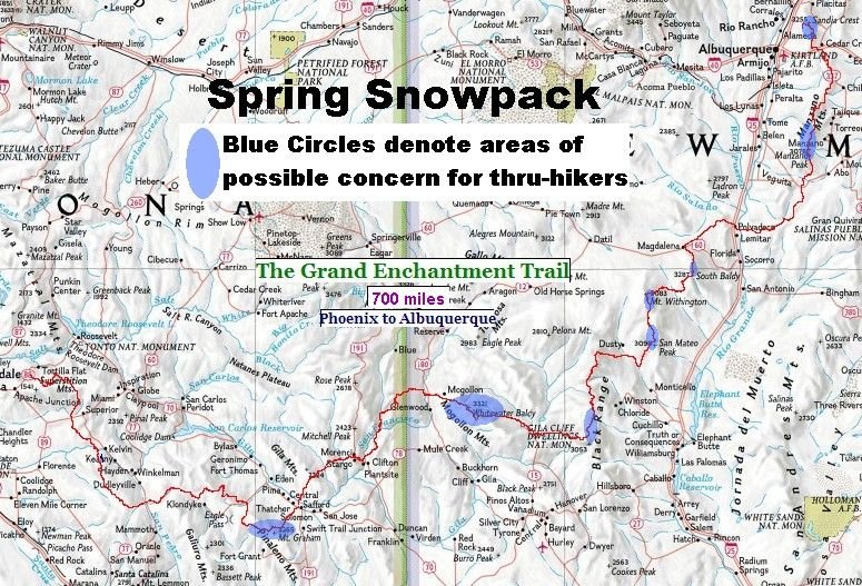
The
following table shows where along the route you may encounter snow when thru-hiking
eastbound during spring seasons of average to somewhat above average snowpack.
| Tr.
Segment | Range |
Area
of Potential Concern | Elevation
| Prevalence
of Snowpack | Bypass
/ Detour
Worthwhile? |
|
10 | Pinalenos |
10-12 mi
| to
10,100' | more
continuous | sometimes |
| 20 |
Mogollons |
10-15 mi
| to
10,770' | more
continuous | often |
| 23,
24 | Black
Range | 0-10
mi | to
9,800' | less
continuous | rarely |
| 28,
39 | San
Mateos | 0-13
mi | to
10,300' | less
continuous | rarely |
| 31
| Magdalenas |
0-5 mi
| to
10,400' | less
continuous | sometimes |
| 35 |
Manzanos |
0-12 mi
| to
10,100' | patches |
rarely |
| 38,
39 | Sandias |
0-7 mi
| to
10,650' | patches |
rarely |
 |
| Snowpack
coverage map - click to view |
With
the exception of the Pinaleno Range, note that the Arizona G.E.T. would be expected
free of snow concerns during a springtime, eastbound thru-hike. Only in the high
country of New Mexico could snow again become a factor, and then generally diminish
in concern as you proceed east and the snowpack continues to melt.
Detouring
to Avoid Spring Snowpack
When
considering whether to skip a snowy section of the route, keep in mind that all
snow isn't necessarily a problem. By its nature, melting spring snowpack is a
ready source of drinking water. It feeds creeks and springs on the mountain ranges,
and can itself be melted over a campfire or stove to provide drinking water. In
this respect, snow can be your ally in an otherwise arid land, in addition to
providing a wonderful contrast in scenery and experience.
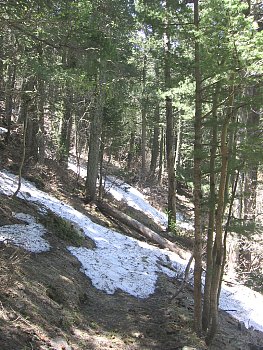
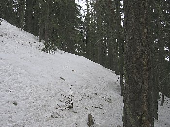 |
| Discernable
only as a corridor through the trees, trail at 9500' in the Mogollon Mtns lies
buried in 2.5 feet of hard, sloping snow, late April '05 |
Snow becomes an
issue wherever it is deep, steep, or prevalent over a large area. Spring snowpack
in the Southwest tends to be inconsistent in its ability to bear loads, and deep
snow can sometimes cause you to posthole laboriously. Where hardpacked or frozen
snow occurs in steeper terrain, exposure to sliding accidents may become a concern,
particularly in open forest environments (cirques and headwalls are not present
in this region, nor is avalanche danger in spring). In addition, most forest trails
that the G.E.T. uses are not marked for winter use, and you may have trouble following
them in untracked snow.
The
guidebook describes specific snowpack concerns and alternate routes to take in
each region. Suffice it to say here that you probably will only need to consider
detouring around portions of two ranges - the Pinalenos (Seg 10) and Mogollons
(Seg 20) - and a mile of trail on the north slope of South Baldy in the Magdalena
Mountains (Seg 31). All other regions you can ordinarily expect will be passable,
with only short snowbound sections or patches of snow that can be circumvented
if necessary.
Use
of Crampons and Ice Axe
Spring
thru-hikers should consider bringing lightweight instep crampons or "ice
walkers" when heading into snowbound segments of the route. These will improve
traction on steep, hard snow, and allow you to follow a trail's line as it switchbacks
or contours along steeper slopes. Unless snowpack is determined to be minimal,
carry crampons over the Pinalenos, Mogollons, and Black Range. Consider mailing
them home from Monticello, or at Magdalena if South Baldy may pose a concern.
An
ice axe would only be warranted if traversing the snowbound Mogollon Range (guidebook
segment 20), rather than detouring around it. Unless you have prior experience
with high altitude snow travel and routefinding, this is the one range to strongly
consider avoiding in a snowy spring. The Mogollons are tall, rugged, and remote,
and you will need to rely on map, compass, GPS, and guidebook to determine where
the snowbound trail in fact goes. Due to the steepness of mountain slopes, you
will face some moderate exposure and should be practiced in self-arrest techniques.
Mail an ice axe to Glenwood, and
carry it as far as Monticello,
for a total distance of about 150 miles. (Or divest yourself of it at Gila
Hot Springs if you can find someone willing to mail it for you.) Otherwise,
walk around the worst of the snowpack and come back to enjoy the Mogollons later
in the season.
Current
Snowpack Conditions
The
USDA National Resources Conservation Service maintains snowpack data for western
states including Arizona and New Mexico. "Snotel" sites monitor snowpack
conditions in real time, and this data is made available on the NRCS website,
offering a snapshot of regional conditions at given elevations. In particular,
Silver
Creek Divide snotel offers an idea of what to expect in New Mexico's Mogollon
Mountains, while McKnight
Cabin and Lookout
Mountain offer perspective on the Black Range. Use this information to get
a feel for the type of snow season (and in turn water season) that is unfolding
across the region.
 |
| Old snow patches
pose minimal concern at 10k on Manzano Peak, mid-May '05 |