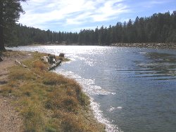
More
than most long distance routes, the Grand Enchantment Trail seeks out the company
of moving water, sometimes following the banks of rivers and creeks for several
miles at a time. All told, the route meanders in the frequent company of these
sources for more than 90 of its total miles. Mountain and canyon creeks are more
likely to be flowing in springtime or soon following rain, otherwise you may encounter
pools of surface water in times of diminishing runoff - especially in rockbound
or steep-walled portions of drainages. Some creeks and rivers along the route
are perennial or very likely to be flowing except in times of prolonged drought.
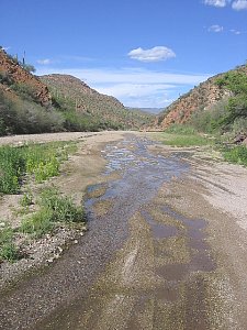
Aravaipa, Bonita, Eagle, and Alamosa creeks, and the San Pedro, San Francisco,
Blue, Gila, and Rio Grande rivers all slice through desert portions of the route,
bringing life-giving water to an otherwise arid region.
| |
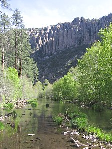
|
| W. Fork
Gila River's perennial flow | spring
snowpack runoff, Cibola NF |
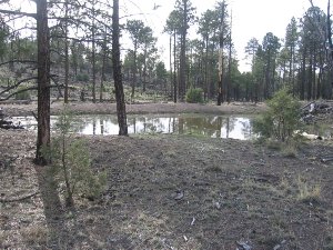
Springs
and Seeps
Our
route also passes a good number of springs along the way. These occur in desert,
canyon, and mountain environments, and vary from intermittently surfacing springs
(or artesian springs) in desert washes, to cliff seeps in steep-walled canyons,
to rivulets and spring pools on the forest floor. Due to the importance of water
in this region, and in order to accommodate stock animals, some springs are 'improved'
and feature piped troughs which act as reservoirs, holding a steady volume of
water and persisting longer in times of drought. Springs and seeps are dependent
on localized near-surface groundwater conditions, so will vary in their rate of
flow and reliability.
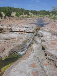
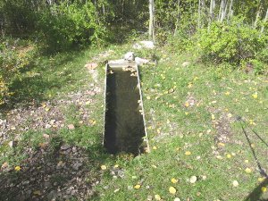 |
Above:
Cub Spring & trough, Apache Kid Wilderness
At right: Artesian spring flow
in Putnam Wash, Tortilla Mtns |
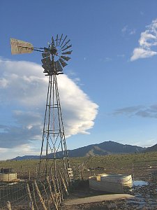
Tanks,
Troughs, and Windmills
Manmade
sources provide a vital addition to naturally occuring surface water along the
G.E.T. Ground or well water pumped to the surface for use by cattle also benefits
wildlife and (where legal to obtain such water, as on public lands where the sources
are not posted private property) hikers and backpackers. Many of these sources
are surprisingly fine-tasting, particularly when taken directly from outlet pipes.
Windmills are of course dependent upon the presence of wind (or sun, in the case
of solar arrays) and on their operating condition, but the tanks (large metal
holding containers) and troughs (lower and smaller, for stock use) that hold windmill
water may contain a supply either way. Other times these catchments are fed via
a float valve which replenishes the supply as it is drawn down by use and evaporation.
Earthen tanks - manmade depressions that hold rain and meltwater - offer yet another
option for hikers, although these sources are perhaps the least reliable and most
likely to be contaminated by cattle (or wildlife), who may wade directly into
these often silty "stock ponds."
 |
 |
At
left: windmill & stock trough, NM
Above: Dry Time Tank (former stock pond),
Black Range NM |
Reliability
of Water Sources on the G.E.T.
The
Grand Enchantment Trail guidebook offers specific information about the water
sources encountered along the way, including type, condition, and reliability.
In addition, the G.E.T. Water Chart - a table
listing water source data by milepoint along the route - provides an informative
summary that should be useful in planning a water carrying strategy. Taken together,
the guidebook and water chart should assist hikers in determining generally which
sources they are most able to count on, which ones might be flowing, and which
are likely to be dry in a given season.
Our
route passes many potential sources of water, many more than might be expected
in an arid region as this. In an average day of hiking, and in a season of average
moisture, you are likely to find multiple sources of potential drinking
water, either on or near route. This is not to suggest that you will often be
able to walk away from a source carrying little or no water in reserve, but that
the route is designed to offer as many options as possible in the event that a
particular source is dry.
 |
| Riggs
Flat Lake, Pinaleno Mtns |
In
a spring season of average precipitation, following an average winter of rainfall
and mountain snowpack, (and barring any significant effects of long-term regional
drought) thru-hikers can generally expect to find drinking water each day of the
journey, meaning that they would probably need to carry no more than a gallon
at a time. Seasons of above average rain and snow - or periods of recent heavy
rain or melt - can produce localized conditions in which water becomes exceptionally
abundant, sometimes flowing in many more places than those listed in the guide.
However, as Arizona and New Mexico continue to trend toward long-term drought,
the opposite extreme is becoming more common - winter and spring seasons of below
average rain and snow, and a resulting decrease in the reliability of water sources.
Thru-hiking in years of low precipitation becomes more challenging, and such hikers
would strongly benefit from prior experiences with desert travel and with lightweight
hiking strategies that facilitate the ability to carry more water. The same also
holds true for most fall thru-hikes of the route, since summer rains are less
reliable or beneficial than winter, and a lack of snowpack in autumn greatly reduces
mountain runoff.
Current
Water Conditions
The
best sources of current information on water conditions are those intrepid scouts
who have recently visited the area in question. Since many portions of the G.E.T.
are remote and seldom visited or reported on, hikers looking for specific information
may need to glean whatever they can from Forest Service and BLM offices. Even
though the representatives at these offices may lack first-hand knowledge of a
particular water source, they may still have a good sense of what to expect, and
can certainly tell you about recent weather and snowpack conditions. A list of
pertinent agencies can be found in the G.E.T. guidebook, and in the Town Guide.
Call or visit these offices to inquire about water as well as trail conditions.
Also
see the following links for recent precipitation data and analysis by state:
NRCS
Arizona precipitation reports
NRCS
New Mexico precipitation reports
Monthly
weather observations, including daily and monthly recorded precipitation totals
and monthly averages, are also available in an easy-to-read format at weather.com,
such as in this
example for Safford, Arizona.
Refer
as well to the Trek Planner section on Creek Fording
for a table with links to streamflow information for select water sources along
the way. Current conditions comparative to average for these creeks and rivers
may sometimes allow you to determine a trend - either toward or away from problematic
regional drought - before committing to an upcoming season of travel along the
route. And speaking of drought trends, the big picture view is available courtesy
of the U.S. Drought
Monitor website,
which provides weekly updates on current regional drought impacts; comparison
of the drought coverage and intensity maps from one week to the next offers a
good snapshot of how wet or dry a given region of the trail happens to be, and
of how the picture may be evolving in advance of your hike.
Water
Management Strategies
A
thorough discussion of water-related techniques for desert travel is beyond the
scope of this planner. Other websites and publications cover these topics in detail,
and of course there is no substitute for real-world experience, especially before
setting out on a long trek in arid country. That said, I'd like to share a brief
list of techniques that have worked well for me while hiking in desert regions
of the Southwest:
 |
| One
gallon of premium unleaded: sediment-rich stock pond water beats dehydration |
- Minimize base
packweight as much as possible, in order to more comfortably carry larger, heavier
loads of water when necessary.
- Never
reject the idea of carrying more water just because of its extra weight, and remember
that this weight will decrease steadily as you hike toward the next source. Plan
to carry what you need to be safe and happy farther down the trail.
- Thoroughly
re-hydrate at every water source before walking away from it. Drink much more
than you think you need. Consider lingering for a while so that you can hydrate
steadily over a period of time, which is more effective than quickly chugging
2 quarts and moving on.
- When
practical, try to cook and camp near water sources. This will reduce your use
of carried water as well as total time spent traveling between sources. Avoid
cooking or camping too close to fragile sources that wildlife and stock also depend
on.
- Unless you
are very confidant in the likelihood of your next potential water source, always
assume that it may not be flowing. How much water would you need to carry if hiking
on to the next probable source? Consider carrying this much water from the outset.
- Drink
regularly throughout the day, rather than rationing your water supply (except
in emergencies). Water can't do you any good if you don't consume it, and a pack
laden with unconsumed water will only increase your water needs through exertion.
Drink and walk. Walk and drink.
- Use
maps and field observations to determine where other water sources may exist that
are not directly along the route. The presence of cattle or fresh dung is a sure
sign of water, likely within a 1 mile radius of your location. In an emergency,
use a small monocular to scout for windmills, tanks, or areas of lush vegetation
on the horizon.
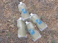
- Carry
several smaller water containers rather than one or two larger containers. Not
only will you lose less water if one container should fail, you'll also be able
to better distribute the load throughout your pack.
Potability
and Treatment of Water
Where
and how you treat your water is a matter of personal preference. A majority of
water sources on the G.E.T. are of good appearance, although it is never guaranteed
that appearances will correlate with actual water quality. Cattle grazing occurs
throughout the region, and outside of stock-excluded wilderness areas and in the
highest and/or remotest terrain, most creeks can be expected to feature some degree
of contamination from these animals. Stock troughs are also "working sources,"
but at least cattle are unable to stand and defecate directly in these sources
(usually), as they often do with stock ponds.
You
will probably want to carry some type of water treatment system on your hike.
Many types of water filters and chemical disinfectants are capable of reducing
pathogens to a level well tolerated by many hikers. Speaking to my own experiences
only, Aqua Mira (chlorine dioxide) has worked well on all of my Grand Enchantment
treks, in the sense that it is lightweight, fairly convenient, and my gastro-intestinal
health has remained good throughout.
Consider
pre-filtering your water whenever organic matter or sediment is present, which
will improve the appearance of the water and the effectiveness of treatment. If
using a chemical system, you can place contaminated water into a bladder or large
container dedicated to this use, then pour it over an open cookpot covered with
a bandana or tubular porous fabric. Empty the pre-filtered cookpot water into
bottles, then chemically treat.
 |
| Drink
Responsibly |