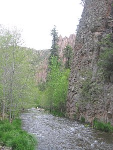
Creek
Fording
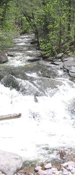 |
| Whitewater
Creek |
Whether
thru-hiking eastbound in spring or westbound in autumn, you will encounter creeks
and rivers that require fording. Most creeks are shallow enough that you can slosh
confidently across as dictated by the trail or terrain, with wet feet and perhaps
slippery rocks your only concern. Other creeks and rivers may be running high
enough that you'll need to wade, or fast enough to warrant your full attention
and a good fording technique. In spring seasons of average to high runoff, or
following recent heavy monsoon-type rain such as in late summer or early autumn,
a few drainages may prove unmanageable, necessitating a detour.
Predicting
generally which creeks and rivers may be more or less challenging is easier than
trying to determine in advance which ones will or won't actually be fordable.
Drainage flow can vary considerably from day to day, and even between night and
day due to variances in snowpack melt rates. And a creek that might pose less
trouble for an experienced forder with long legs could prove unfordable for someone
else. For these reasons, only a firsthand scouting of a drainage will reveal its
true nature. Don't adjust your itinerary solely on preconceptions about this or
that creek; rather, wait until you get there before deciding whether you can safely
cross it or should find another way.
The
following chart indicates which of the creeks and rivers confronted by the main
route of the G.E.T. may occasionally be running high and/or fast enough to warrant
consideration. The bypass options presented correspond with "alternate route"
descriptions in the online guidebook for each segment.
| Segment |
Drainage |
Seasonal
Concerns | #
Fords | Bypass
/ Detour
Necessary? |
|
14 |
| spring/poss.fall:
current, depth, # fords
bypass: detour on dirt & paved rds. avoids
all but 1 ford | 50+ |
sometimes |
| 16 |
| spring:
current
bypass: none convenient | 1 |
rarely |
| 18 |
| spring:
current, depth
bypass: bridged crossing 1 mile away by road |
1 |
rarely |
| 21 |
W. Fork
Gila R. | spring:
current, # fords ; fall: # fords
bypass: nearby trails avoid
most fords | 60 |
sometimes |
| 22 |
Middle
Fork Gila R. | spring:
current
bypass: nearby trails avoid all fords |
6 |
rarely |
| 33 |
| spring/fall:
current, depth, width
bypass: bridged crossing 6 mi away by road |
1 |
often in
spring |
See
the related G.E.T. guidebook segments for a discussion of specific fording scenarios,
and when and how to avoid them. But please note here that the number of fords
dictated by a particular drainage is secondary in concern to the condition of
the creek or river itself. The multiple fords of Eagle Creek and the Gila's West
and Middle forks are a part of the rugged trail experience in these scenic canyons,
where steep cliffs force the trail back and forth across the drainage at bends.
Aravaipa Canyon is similar in design, as is the normally gentle Alamosa Creek
near Monticello, New Mexico. When conditions are safe, these remote and watery
canyon experiences can be a memorable highlight of the G.E.T. - challenging, in
some cases, but also wild and rewarding.
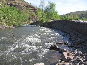 | 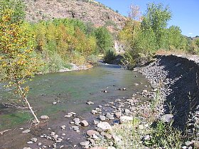 |
| A
River Changed: (at left) San Francisco River runs waist-deep and quick, spring
'05, posing a much greater challenge than in fall of the same year (at right).
(Note: Due to flooding concerns, the GET no longer follows the San Francisco River
Gorge in AZ.) |
Fording
the Rio Grande
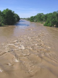 |
| Rio
Grande in flood, early May '05 (photo taken from bridge along detour) |
One river along
our route presents more of an obstacle to travel than a right of way. The Rio
Grande, which the G.E.T. reaches near the village of Polvadera NM, is typically
20 or 30 yards wide, and in many spring seasons when thru-hikers normally arrive
is high and quick enough to categorically rule out fording. Instead, eastbound
hikers would detour to a bridged crossing, adding several miles to the route in
the name of safety. Westbound hikers in autumn are more likely to find a still-wide
but relatively calm and shallow Rio Grande, and may prefer the adventure and time
savings of fording this ribbon of life in the desert.
A
lightweight packraft or extra-thick air mattress might present the option to float
across the Rio Grande, and may be worth considering for those who enjoy such adventurous
modes of problem solving more than following detours. In fact one springtime thru-hiker,
Li Brannfors, did precisely this, having purchased a "car camping" style
air mat at the hardware store in Magdalena, then carrying it in place of his regular
pad for the remainder of his trip, floating the Rio with the aid of a piece of
found styrofoam as a "paddle." [ photo
of Li floating the Rio ]
Obviously
a packraft in particular would receive minimal use for the time spent carrying
it, but under the right circumstances these lightweight inflatables might nevertheless
come in handy. In fact a number of creeks and rivers along the route would lend
themselves to extended
packraft touring when running near flood stage, but then that's another sport
for another guidebook!
Current
Streamflow Conditions
The
above table also features links to USGS current streamflow data for several of
the more prominent creeks and rivers along the G.E.T. in Arizona
and New Mexico.
In each of these
cases, the measuring gauges are located nearby the route, so data is "representative"
of field conditions as if you were confronting these bodies of water in real time.
However, in my experience the "gage heights" shown on these graphs greatly
overestimate the actual depth of water that a forder would confront - perhaps
by 200% or more. As well, it is impossible to compare the current of one creek
against another using these graphs, since streamflow measurements (in cubic feet
per second) alone say nothing about the creek's width or variance of depth between
banks. More useful is to compare the current flow (discharge) and gage height
of each creek to average (aka mean) conditions for a given date; at springtime
averages, most of these waters would likely be fordable when arriving on a thru-hiker
schedule, with the notable frequent exception of the Rio Grande. But whatever
the case, wait until you actually see the river before deciding what to do. (Please
note that the triangle symbols on the USGS stream discharge graph indicate median
flow for a given date, rather than mean (average), which is listed in the accompanying
table.)
Beyond
the larger creeks and rivers, the USGS site lists additional streamflow data pertinent
to G.E.T. hikers, none of it related to fording concerns along the route, but
useful nonetheless in taking a rough sample of water source conditions along or
near the route. (None of this data should be used to predict the current status
of G.E.T. sources not listed on the USGS site, nor those encountered a significant
distance upstream or downstream from the measured location.) These sources include
the following, listed from west to east:
Queen
Creek below Whitlow Dam (well downstream of GET crossing W of Superior, Queen
Creek is usu. dry at the GET)
Aravaipa Creek near Mammoth AZ (downstream of Aravaipa Canyon, where flow
is typically diminished)
Frye
Creek near Thatcher AZ (drains from Mt Graham in the Pinalenos)
Gila
River at head of Safford Valley (route crosses the Gila near here on road
bridge)
Bonita
Creek near Morenci (likely measured downstream of GET crossing)
Mogollon
Creek near Cliff NM (not near the GET, but possibly indicative of Whitewater
Creek & Mogollon Mtn drainages)
Gila
River near Gila NM (not near the GET, but closest measurement to source waters
in the Gila Wilderness)
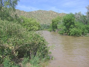 |
| Gila
River in springtime: near Kelvin AZ (above)
in the Sonoran desert; West Fork,
(at right) 300 trail
miles to the east in the Gila Wilderness |


