Simblissity
home >
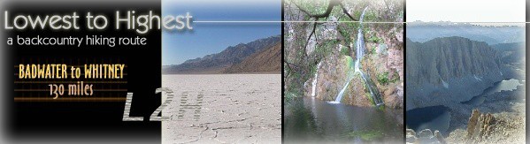
L2H
The
challenge is classic. The starting point and finish are pure and uncontrived.
And accomplishment is a high on par with the alpine crags around you, soaring
over a furnace desert beyond.
For
several decades adventurous souls have sought the challenge of traveling on foot
from the lowest point in the Western Hemisphere to the highest place in the contiguous
United States. Starting at Badwater in Death Valley, California, at an elevation
of 279 feet below sea level, they test their mettle on a scorching ribbon of asphalt
highway, over mountain passes and across sere basins, and on into the shadow of
Mount Whitney, 14,505-foot king of the mighty Sierra Nevada range.
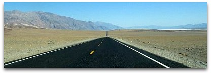 |
| Badwater
Road, near the start of the paved race route | Many
come in summer, when valley air temperatures can exceed 125 degrees Fahrenheit
(52 C), and attempt to run the 130+ mile distance, either competitively - with
outside support - or self-contained, challenging only themselves. The approach
differs with the individual, but the route is almost always the same. Over the
years, only a handful have left the highway to travel their own way "from
the Lowest to the Highest..." Introducing
the Lowest-to-Highest Route
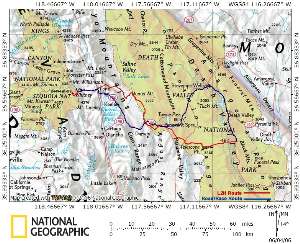 |
| Overview
Map - click to view full size | The
Lowest-to-Highest (L2H) is a backcountry hiking route between
Badwater and Mt. Whitney. Unlike
the traditional "race route," the L2H avoids pavement and vehicle traffic
whenever possible, in favor of a scenic, silent journey across the wilderness,
as it seeks the soul of a rugged, harsh, and ultimately beautiful land. If the
traditional approach is to complete an extreme journey on foot, then the L2H is
about living completely in a land of extremes. Indeed, this off-highway journey
encompasses even greater extremes of geography, ecology and climate, and is intended
to immerse the traveler far more deeply within the environment. In
terms of the route's layout, the Lowest-to-Highest Route represents the first
genuinely "backpacker-oriented" way to get from Badwater to Mt. Whitney.
The L2H was designed to meet the expectations of seasoned walkers looking for
a challenging one or two week trip through desert, mountain, and alpine terrain.
To this end, the route offers a number of advantages: - Provides
a sense of solitude and an opportunity for contemplation of nature away from major
roads, traffic, and other manmade intrusions.
- Travels
across scenic, interesting and varied terrain, and over a wide range of elevation
and climate.
- Follows
an efficient line of travel between its end points in order to minimize distances
between water and resupply.
- Affords
direct access to natural and developed water sources, as well as cache locations,
so as to reduce the sense of dependency or discontinuity during the actual journey.
- Returns
to civilization occasionally to facilitate resupply of food and provisions, as
well as for rest and recovery.
- Connects
to the southern terminus of the John Muir Trail and nearby PCT, offering options
for extended travel into the High Sierra backcountry and beyond.
[ top of
page ] Character
of the Route
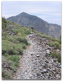 |
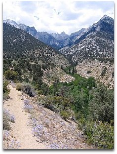
|
Telescope Peak Trail | The
Lowest-to-Highest is in fact a route - an informal, unsigned linkage of existing
trails, roads, and cross-country travel. Few established trails exist in Death
Valley National Park or elsewhere in the areas immediately east of the High Sierras
and Mt. Whitney. However, the area is threaded by numerous old roads, many of
them former miners' routes, little more than rockbound tracks in some cases. Cross-country
travel is often facilitated by the expansive desert landscapes here, which include
everything from flat, featureless salt playas, to the lightly-vegetated slopes
of arid mountain ranges, to vast alluvial fans at the mouths of canyons. And
yes, several foot trails are found here as well - some of them well-traveled and
in excellent condition, in other cases just a rough path with occasional rock
cairns to guide the way. Each of these surfaces and modes of travel come together
to make the L2H the diverse, challenging and rewarding experience it is. Distance,
Elevation & Terrain Total
mileage from Badwater to Mt. Whitney is surprisingly similar between the highway
race route and L2H route. The L2H travels a distance of about 130 miles from end
to end, compared to the race route's 135 miles. In fact the race route ends at
Whitney Portal, 8 miles and several thousand feet below Mt. Whitney's summit,
so the "peakbagging" L2H - which goes straight to the top - is comparatively
more efficient overall, at least by the mileage figures. But the more distinguishing
difference between the two routes is elevational: By seeking out an adventurous
line of travel away from major roads the L2H features a total elevation gain more
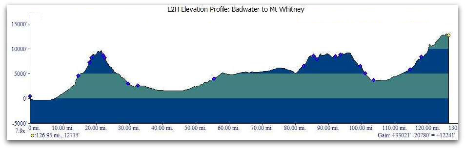
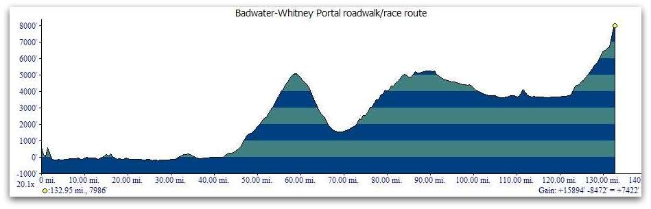
than double that of the highway route. The following elevation profiles offer
a visual comparison of the two routes. (Please note the difference in vertical
exaggeration between the two profiles.)
| |
|
| Comparison
of Elevation and Length: L2H (at left) & Race Route (vertical exaggeration
differs) |
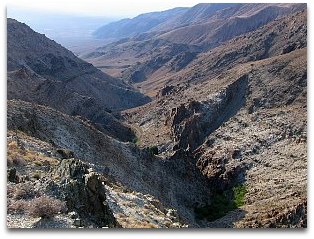 |
Long
John Canyon, Inyo Mountains
| The
difference in total elevation gain between the routes is the result of topography
and the way each route confronts it. Much of this land is at the western edge
of the vast Basin and Range province, with fault-block mountain ranges rising
sharply out of deep, wide valleys. By adhering to paved 2-lane highways that follow
the path of least resistance, the "race route" does not climb as high
nor as often as the L2H, which approaches the ranges directly, via more primitive
and steeply graded surfaces. The
L2H confronts three major ranges - the Panamints, Inyo Mountains, and the eastern
edge of the Sierra Nevada massif at Mt. Whitney - and along the way crosses Death
Valley, Panamint Valley, and the valley of the Owens River. Elevations on the
crests range from 9000 feet above sea level to over 14,500' at Mt. Whitney. Valley
elevations are much lower - so much lower in the case of Death Valley that the
climb into the Panamint Range (to Telescope Peak) represents the fourth greatest
valley-to-summit elevation gain in the United States, just behind Washington's
Mt. Rainier. In addition, east of the Inyo Mountains the L2H follows the rolling
5000' Darwin Plateau for a number of miles, with easier hiking and more moderate
temperatures. [
top of page ] Highlights
of the Adventure 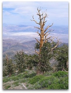 Change
is seemingly the only constant on the Lowest-to-Highest. Perhaps nowhere else
on earth can a person so quickly travel on foot between markedly contrasting environments,
between worlds so far apart in character that it is hard to reconcile their physical
proximity. Change
is seemingly the only constant on the Lowest-to-Highest. Perhaps nowhere else
on earth can a person so quickly travel on foot between markedly contrasting environments,
between worlds so far apart in character that it is hard to reconcile their physical
proximity.
Such
is certainly the case in the journey's early miles. The route leaves Badwater
- an undrinkable saline pool - crosses the harsh, flat, and often torrid salt
playa of Badwater Basin - at 282 feet below seal level the lowest point in the
Western Hemisphere - then ascends over 10,000 vertical feet to the crest of the
Panamints near Telescope Peak, where thousand-year-old bristlecone pines thrive
in the short growing season between long, cold winters. 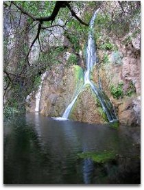 Or
imagine walking among desert canyons of bone-dry greasewood and endless rock,
only to turn a corner and discover the miracle of Darwin Falls. Here, a series
of perennial cascades dash among shade trees and lush undergrowth. Bird song fills
the air, punctuated incongruously with the "hee-haw" of a feral burro
hidden somewhere up-canyon, living testament to a bygone era when miners and mule
teams did heavy work here. Or
imagine walking among desert canyons of bone-dry greasewood and endless rock,
only to turn a corner and discover the miracle of Darwin Falls. Here, a series
of perennial cascades dash among shade trees and lush undergrowth. Bird song fills
the air, punctuated incongruously with the "hee-haw" of a feral burro
hidden somewhere up-canyon, living testament to a bygone era when miners and mule
teams did heavy work here.
 Strange
spikey forms dot the distant horizon ahead, looming taller as the route approaches
its first stand of joshua trees, great sentinels of the Mojave desert. Their multi-armed
masses form a veritable army of green and gray across the expanse of Lee Flat,
yet make no sound to stir the utter silence of the land. Strange
spikey forms dot the distant horizon ahead, looming taller as the route approaches
its first stand of joshua trees, great sentinels of the Mojave desert. Their multi-armed
masses form a veritable army of green and gray across the expanse of Lee Flat,
yet make no sound to stir the utter silence of the land.
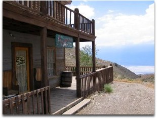
Colorful
mine tailings and even a wooden ore tramway reveal the human history of the rugged
Inyo Mountains, where the past comes alive at the ghost town of Cerro Gordo. The
American Hotel is located here, a real Old West saloon and guest house occasionally
still serving travelers today, "especially those romantics born a century
too late," says the proprietor and sole resident here at 8000 feet.
 |
| photo
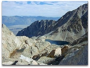
courtesy David Hough | Reaching
Trail Crest and the eastern divide of the mighty Sierra Nevada, you turn north
to join the John Muir Trail and walk a narrow ridge far above treeline. The sky,
reflected flawlessly in alpine lakes below, is blue and confident but the air
is thin, forcing you slowly, euphorically ahead. Ever higher you climb, past sun-cupped
snowfields, among pinnacles, to the very top of the world it seems. The summit
of Mount Whitney commands a view of peaks more numerous than all the sands in
the desert, you think to yourself. And there, below and to the east, the route
you've journeyed for more than a week slips away toward the distant horizon, back
to the sand, salt and heat of Badwater in a universe all its own. [
top of page ] Strategies
for Success Hiking
the Lowest-to-Highest Route safely and successfully requires a familiarity with
both desert and alpine environments, their particular challenges and demands,
and the equipment and techniques for dealing with them. By its very nature, the
route is neither easy nor without risk; indeed, this is a land of potential danger
beyond the norm. Furnace-dry heat, strong sun, an infrequency of natural water
sources, and rugged, steep, remote terrain are standard fare when traveling in
this harshest of desert lands, while snowpack,
cold and/or changeable weather, afternoon thunderstorms, and altitude sickness
can become concerns at higher elevations along the route. The information presented
here assumes an ability to accept and respond to such potential hazards along
the way, as well as a proficiency with the particular requirements of long-distance
hiking that involves resupply and/or backcountry caching. Do not approach the
route unprepared. Season
of Travel
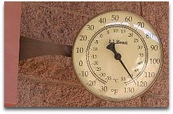 |
| Death
Valley digits: "a little warm" for late June |
The Badwater to
Whitney foot race occurs each year in July, typically the hottest month in Death
Valley, where the all-time high temperature record stands at an otherwordly 134
degrees Fahrenheit (56.7 C). Meanwhile, snow can fall in the high country beginning
in mid-autumn, with remnant snowpack sometimes blocking trails on Telescope Peak
into the following June, and on Whitney into July. The
upshot of these limiting factors is a narrow seasonal window in which to travel
the Lowest-to-Highest without undue hardship. In essence, the L2H is open to traditional
thru-hiking (which is to say, minus a mountaineering component) only during the
months of September and October, after the desert heat lessens and before the
early snows arrive. In most years, a start date at Badwater during the first week
of October should allow enough time to reach Mt. Whitney before ice or snow make
conditions hazardous there. Make no mistake though - the lowest terrain of the
route may still be quite warm to downright scorching, even well into October.
Other times, the weather can be chilly and inclement, including at the bottom
of Death Valley. Navigation:
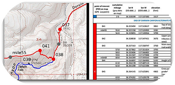
Maps and Databook Because
the L2H is an unmarked, unsigned route, detailed topographic maps are absolutely
essential for navigation as well as for an understanding of the terrain through
which the route travels. To this end, we now offer a complete "navigation
bundle" for prospective hikers which includes high-resolution, annotated
topo maps, elevation profiles, and a companion databook, as well as GPS tracks
and waypoints. The maps and databook are presented in easy-to-use PDF file format,
and they can be printed either at home or using a professional document printing
service like FedEx Office. The GPS data is formatted for compatibility with most
current GPS units. Click on the following link to view and download the navigation
bundle. This
resource has been some time in the making, and we hope it simplifies the planning
process for prospective hikers. We've opted to make it available to try for free.
If you find it useful and would like to support our efforts to keep this resource
up-to-date, then please consider purchasing the navigation bundle above. The
maps, databook, and GPS info detail the main route of the L2H as well as a number
of "alternate routes" that hikers may opt to use along the way. The
alternates are typically a few miles longer or shorter than the portion of the
main route they replace; some of them may prove easier in some way, either in
terms of the terrain or logistics, while others may be more scenic or adventurous.
Refer to the maps and databook for more info. Along
with the maps contained in the navigation bundle, additional large-area overview
maps can also prove helpful in finding your way. The DeLorme California Atlas
& Gazetteer offers a broad perspective of the terrain, including roads leading
away from the route toward developed areas where assistance would be available
if needed. Trails Illustrated produces a folded, waterproof map of Death Valley
National Park, with numerous secondary and primitive roads and even some trails
and x-c routes depicted. Additionally, the entire L2H route is covered (without
actual route depiction) in 1:100,000 scale detail on four maps produced by the
BLM. Visit the Public
Lands Interpretive Association website to order the BLM's Death Valley Junction,
Darwin Hills, Saline Valley, and Mount Whitney surface management maps.
Locating
Water With
an average annual rainfall of less than 2 inches, coupled with high temperatures
and low dew points, Death Valley defines aridity in sharper terms than almost
anyplace on earth. Yet the ranges that rise so prominently above Death Valley
and surrounding basins do capture precious moisture from occasional weather systems,
draining it into the basins to evaporate in salt pans or well up in unusual, unpotable
ways as at Badwater. These ranges also retain some of their moisture, as evidenced
by their more abundant flora and fauna. And in a few places this vital water runs
at the surface, clear and drinkable. A
lack of abundant natural water sources is a fact of life on the Lowest-to-Highest
Route, at least before reaching the Owens Valley at the edge of the well-watered
Sierra Nevada. In its desert reaches, hikers will at times need to carry a considerable
amount of the wet stuff - perhaps several gallons - and walk with a purpose from
one known source to the next.
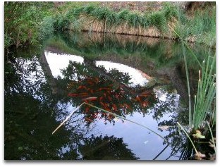 |
| High
desert surprise: goldfish in China Garden Spring | The
L2H route has been carefully laid out to make the water situation as manageable
as possible for experienced desert travelers. Several natural sources are encountered
along the way, of which a few are fairly dependable. Developed water is also reached
at intervals throughout the route, and can generally be counted on during the
normal hiking season. The L2H Navigation Bundle includes a water summary which
is periodically updated based on reports from hikers along the route. It also
lists potential on-route cache locations, where one could leave a supply of water
beforehand to be picked up during the hike. (See the following discussion.) | | VIEW
AND PRINT THE WATER SUMMARY HERE |
Water Caching At
first glance, the above water chart may seem to indicate that water caching is
unnecessary on a thru-hike of the L2H. And for experienced desert hikers willing
to pack heavy water loads, it may not be necessary. But for safety's sake more
than mere convenience, all hikers, regardless of ability or inclination, should
at least consider caching some water along the route.
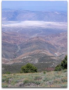 |
10k vertical feet cross-country elevation gain | Three
areas of the route in particular suggest the benefit of water caching: the western
and eastern base of Telescope Peak, and the long stretch without surface water
west of China Garden Spring. The climb of Telescope Peak's ridge is steep, extremely
long (10,000+ feet of elevation gain), remote, and mostly cross-country. Although
Hanaupah Spring to the east is considered reliable, what happens if your arrival
is delayed by the unexpected? Or what if the springs in Tuber Canyon happen to
be dry when you're absolutely counting on them? To be caught on either side of
the mountain with empty water bottles could very easily prove disastrous. Water
caches left at nearby road crossings would provide a margin of safety, and make
this challenging ascent and descent much more manageable, especially as the caches
would permit a more deliberate pace in difficult terrain. Water left near the
entrance to Hanaupah Canyon at the western edge of Badwater Basin would also help
to ensure a safer and more enjoyable crossing of this lowest, hottest, driest
region at the very start of the route. Setting
up a last minute water cache on the route about 7 miles west of China Garden Spring
would be fairly straightforward. Upon reaching the store at Panamint Springs,
one could purchase water in plastic jugs and then hitchhike 12 miles west along
the highway to its next intersection with the L2H route. There, the hiker could
hide the water nearby in desert brush, then hitch back to Panamint Springs and
continue along the route, retrieving the cache on foot in a day or so. (And being
sure to pack out all supplies from the cache!) Additional
water caches would require more targeted vehicle assistance. For those with no
outside support, one tested solution would be to rent a car in the town of Pahrump,
Nevada, 1.5 hours east of Death Valley National Park. This would be done prior
to arrival at Death Valley, for example if flying into Las Vegas beforehand. After
placing the water caches, one could either return to Pahrump and then hitch back
to the Death Valley area, or potentially arrange to have the vehicle picked up
by the rental company for an extra charge. In this last scenario hikers could
arrive at Badwater under their own power and start the hike on a schedule of their
choosing. Resupplying
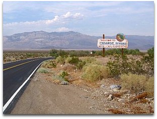 | |
Welcome
to Panamint Springs Resort (just around the bend) | The
Lowest-to-Highest Route offers two potential opportunities for resupply along
the way. Packages of food and supplies can be shipped to Panamint Springs Resort
(with prior permission) and the town of Lone Pine prior to the hike, then picked
up along the way. The route heads directly through both localities. Although
the Panamint Springs resupply may not be truly necessary on a hike of this length,
it can still be helpful in terms of reducing overall packweight; by minimizing
the weight of food supplies, it becomes easier to carry the heavy loads of water
which are sometimes unavoidably necessary. Panamint
Springs Resort has a campground, motel, restaurant, and small store with mostly
snack items. Maildrops may be held at the discretion of the proprietor, and must
be shipped via UPS only. Call to confirm details: (775) 482-7680. Be sure to mention
that you'll be hiking through Death Valley and give an approximate date of arrival.
For best odds when calling, you might also plan to reserve a motel room for when
you'll be passing through. Lone
Pine is a small, tourist-oriented town with most services available, including
a medium-sized grocery store. Sending a maildrop would probably be unnecessary
if heading west toward nearby Mt Whitney, but might be helpful if intending to
continue on the JMT beyond Whitney or if hiking eastbound on the L2H toward Badwater.
The Lone Pine post office (zip code 93545) accepts packages addressed for general
delivery. A small
store is also located at Whitney Portal at the base of the Mt Whitney Trail. The
store sells snack items and has a grill with limited menu options.
Permits
 |
Whitney
Portal National Recreation Trail,
en route to Permit Country |
In its final 8 miles
the L2H ascends Mount Whitney via the main Mt. Whitney Trail and John Muir Trail.
Due to the extreme popularity of hiking Mt Whitney, access to the summit and summiting
trails is available by permit only. A lottery is held each spring for reservations
to hike Mt Whitney in the current season. Lottery winners (typical odds of success
are only 25-30%) then pay for a specific entry date (their preferred date, else
an alternate). Any dates that remain after the lottery are then made available
to the general public on a first come, first served basis. In the past, the possibility
existed to obtain a "walk up" permit at the Inyo National Forest office
in Lone Pine. This option is no longer available, and all permits must now be
obtained online via the Recreation.gov
portal. During
the peak hiking season in July and August permits to enter the Mt. Whitney Zone
from Whitney Portal are generally all reserved well in advance, and permit openings
due to cancellations - although possible - are less likely at this time. September
and October can pose less of a concern, although L2H hikers will still benefit
from being as proactive as possible in searching for any available permit date
and then timing the journey around that date, within reason. "Non-quota season"
extends from early November to late April each year, meaning no limits are placed
upon entry during this time, with the earlier portion of this season increasingly
in play due to climate change, albeit one should always be prepared for winter
conditions near the summit at this time of year. [
top of page ] The
Route In Abstract From
Badwater (279 ft below sea level), the L2H heads west across Badwater Basin to
Hanaupah Canyon, where it follows 4WD road to Hanaupah
Springs. [e.g., 1st camp] It then proceeds cross-country to
Telescope Peak's ridge (10,000 ft), northbound via the Telescope Peak Trail, then
west x-c into Tuber Canyon. An old track in Tuber Canyon passes a few potential
springs, [2nd camp] and continues downhill
to Wildrose Road (2500 ft), where the L2H joins faint dirt tracks northwest to
sere Panamint Valley and the village of Panamint Springs,
with food and water available (el. 2000'). [3rd camp: motel or campground]
Scenic, perrenial Darwin Falls and China
Garden Spring lie southwest of Panamint Springs, which the L2H
approaches before proceeding cross-country on rocky, volcanic slopes through the
untracked Darwin Falls Wilderness [4th camp] to a junction with the Highway
190 "race route" (4800'), then north via Saline Valley Rd toward Lee
Flat joshua tree forest (5500'). From a road junction along the historic White
Mountain Talc Rd (4900') [5th camp], the L2H climbs westward to the living
ghost town of Cerro Gordo along the rugged Inyo Mountain crest, then turns north
on 4WD to Mexican Spring (9200') and the
ruins of the Saline Valley salt tram. A vague, cairned trail heads west downhill
in Long John Canyon, past a possible spring
(5800') [6th camp], and into the Owens Valley via Lone Pine Narrow Gauge
Rd to US 395 and the town of Lone Pine. (3700')
[7th camp: motel] Here the L2H joins the Badwater-Whitney Portal roadwalk
route for part of the way up Whitney Portal Rd, but leaves it for good at Lone
Pine Campground (5900') to follow the Whitney Portal National Recreation
Trail. The route is concurrent with the Mt Whitney Trail from Whitney
Portal (8300') [8th camp: Whitney Portal Campground walk-in backpacker
campsites, reservations required]
to Trail Crest, then follows the John Muir Trail to its terminus at Mt Whitney's
summit.  Death
Valley Weather Forecast Death
Valley Weather Forecast
Current
snowpack at 11,400' near Mt Whitney
[
top of page ] L2H
Interactive Map Take
a virtual tour of the Lowest to Highest Route with Google Maps. The following
interactive map illustrates the route of the L2H (in red) as well as various alternate
route options (blue). Toggle betwen a traditional map view and satellite imagery
for an informative look at the varied landscapes through which the route passes.
L2H
on Instagram 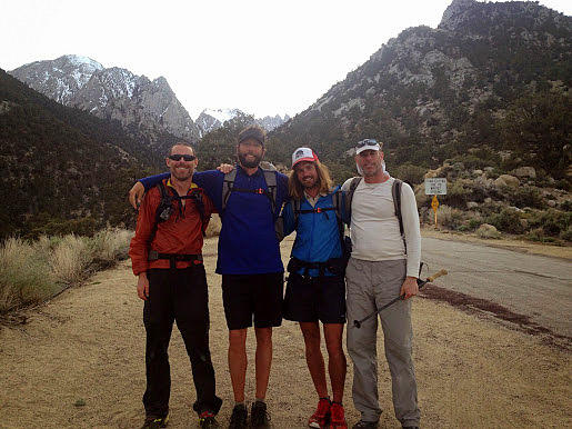 | Cam
"Swami" Honan, Ryan "Dirtmonger" Sylva, Joshua "Bobcat"
Stacy, and Greg "Malto" Gressel
after finishing their L2H thru-hike.
(Photo by Cam Honan) |
#LowestToHighestRoute
| #LowestToHighest
| #L2HRoute
|
#LeaveNoTrace
| #PackItInPackItOut
Please
do your part and do not leave anything behind after your hike, including
all water / supply caches. These will otherwise become litter. We,
as well as DVNP, the BLM, and Inyo NF, appreciate your help. Click
here for more info.
[
top of page ]
Copyright
© 2025 simBLISSity Ultralight Designs  |
|