Grand Enchantment Trail    PDF mapset + GPS data (v3.4)


The official source for topo maps & GPS data
for the 770 mile Grand Enchantment Trail


G.E.T. Topo Map Set v3.4 - click / tap to view a full-size sample map from the series


NEWLY UPDATED FOR THE 2024 HIKING SEASON

PDF MAPSET + RESOURCE BUNDLE
Easy app-enabled printing & viewing of maps. + Navigation ready: maps also load in the free Avenza GPS app. + Includes tracks & waypoints for GaiaGPS & other popular navigation apps & GPS devices. + 190-page PDF Data-Guide and more.


PRINT MAPS OR USE PHONE APP (OR BOTH!) - YOUR CHOICE WITH THE NEW AVENZA-READY MAPSET


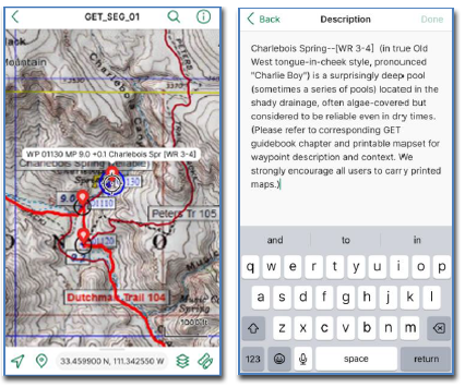
Richly illustrated by GET founder and long-distance hiker Brett Tucker, this digital mapset contains all of the detailed topographic maps you'll need to navigate the Grand Enchantment Trail. Here you'll find over 100 high-resolution, print-ready maps showing the entire GET route and its terrain, along with mileages, navigational notes, waypoints and much more, all viewable and printable from a computer, tablet or smartphone. This mapset also contains a set of custom overview maps with elevation profiles, highlighting the route's location, length, and terrain between each of its resupply points. Detailed GPS tracks and waypoints for the entire route are included in multiple formats for easy transfer to popular hiking apps such as GaiaGPS or a standalone GPS device.

All maps are PDF files formatted for 8.5" x 11" home printing as well as easy uploading to document printing websites such as FedEx Office.

All new version 3.4 now offers a no-print option as well, with the ability to load the detailed topo maps into the free Avenza Maps GPS app. Get all the benefits of carrying the illustrated maps along with the navigational certainty of a "you are here" icon showing your location right on the map, right on your phone screen!

Contents and features:

  • 121 full-color topographic maps in PDF file format, USGS 7.5' quad detail with tons of GET-specific information added. Includes coordinate grids, scale bar, color-coded route details, mileages, numbered waypoint references, water sources and camping locations, and helpful notes on navigation and conditions.
  • 11 USGS 1:500,000 series customized overview maps of the route, with elevation profiles, showing location, terrain, and distances between resupply points.
  • Additional high-resolution area maps, an interpretive full-route elevation profile, 3D-shaded relief map, and surface features map reveal the entire route at a glance.
  • Brand new Avenza Maps GPS app-compatible version of the above topo maps, offering all the same detail and benefits but on a phone screen, along with your location displayed on the maps as you hike.
  • Nearly 1300 detailed waypoints, keyed to the map data and available in GPX, KML, and JSON formats for uploading to a wide variety of GPS devices, smartphone apps, and mapping software.
  • 190-page PDF "Data-Guide" waypoint list, showing each of the mapset waypoints by name and description. This is a 100,000 word document highlighting the tremendous amount of navigational detail now provided in the waypoint data.
  • Detailed GPS tracks of the entire route, organized by trail segment and including alternate routes. All track files are available in both GPX and KML formats for strong compatibility with GPS units, smartphone apps, and mapping software.
  • User Guide file provides complete instructions for use

System requirements: Saving the mapset download to a PC or Mac occupies ~900 MB of internal storage space (alternatively, Download version can be accessed in the Cloud via PC, Mac, Android or iOS). Color InkJet or LaserJet printer if printing at home. Adobe Acrobat Reader recommended for viewing and home printing of PDF maps and other PDF documents.


sample topo map
click thumbnail for full-size image


BUY THIS ITEM

Shop all items


Disclaimer: While it is our hope and endeavor that the G.E.T.. digital mapset will allow experienced users to avoid most navigational problems and will contribute to a rewarding adventure along the route, we do not guarantee the 100% accuracy of these maps and GPS data and other information provided, and assume no responsibility for their use or misuse. Hiking and backpacking are inherently risky activities, so be sure to use these maps as part of an overall approach to maintaining safety in the backcountry, and do not assume their endorsement of a particular road, trail, or creek crossing, etc. Conditions in the field can change, sometimes quickly, and property boundaries can be redrawn to exclude public access. In short, use the maps and benefit from them, but use your skills and your awareness too. And always keep your options open when determining the safest and most practical direction of travel.


Copyright © 2024 Simblissity Ultralight Designs

PURCHASE THIS
ITEM BELOW


Grand Enchantment Trail
PDF mapset + GPS data


Digital Mapset with printable
& smartphone-ready maps, plus tracks & waypoints


(EXISTING MAPSET OWNERS, WHENEVER A NEW VERSION IS RELEASED, YOUR FILES WILL AUTOMATICALLY UPDATE AT THE EXISTING URL / EMAIL LINK.)


$40

DOES NOT INCLUDE PHYSICAL DELIVERY OF PAPER MAPS. MAPSET DELIVERS DIGITALLY VIA EMAIL LINK, USU. WITHIN 24 HRS.

Receive online (cloud) access with full download capability, via Google Drive. Includes access to future updates. Mapset does not include physical delivery of paper maps and this option is unfortunately no longer available.


Ordering Info